
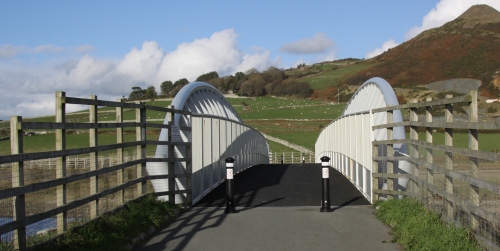
 It was such a lovely day again that I decided to walk the short stretch along the road that runs along the side of the railway from Tywyn to the new Tonfanau Bridge over the river Dysynni. It forms part of the Welsh Coast Path, which follows long sections of the 882 mile Welsh coastline, with some unavoidable detours inland. Until recently one of these detours was where the Welsh Coastal Path met the river Dysynni at the point at which it opens into the sea. Here it was necessary to divert inland along the Dysynni as far as Bryncrug, returning on the other side of the river to rejoin the coast, an admittedly very attractive detour of some eight miles. In January 2013 this all changed when a new 50m bridge was installed to link the two parts of the Coast Path.
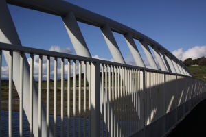 The bridge is of an unusual design, formed of twin crescent-shaped sides of white tubular steel. It is a type known as a Vierendeel bridge, named for its inventor, the Belgian civil engineer Arthur Vierendeel (1852-1940), defined by vertical trusses, rather than the usual diagonal ones. This creates rectangular rather than triangular spaces between the trusses. Most Vierendeel bridges are in Belgium. The bridge cost £850,000 and was funded by the Welsh European Funding Office, Traac, the Countryside Council for Wales and Gwynedd Council. It was installed on the 16th January 2013 by Jones Brothers of Ruthin. It is the largest span for a Vierendeel truss footbridge in the UK. It takes pedestrians, cyclists and horse riders. The Tonfanau Bridge takes its name from the nearby village of Tonfanau, which has an interesting history in its own right and will be discussed at a later date.

Section of the Ordnance Survey Explorer Map (OL23 Cadair Idris and Llyn Tegid) showing the Wales Coast Path, and the start and end point for the short walk between Tywyn and the Tonfanau footbridge over the Dynsynni. Click to enlarge.
The Wales Coast Path (Llwybr Arfordir Cymru – www.walescoastpath.gov.uk) opened in May 2012 and extends between Chester in the north to Chepstow in the south, following the line of the coast wherever possible. The route between Aberdovey and Tywyn goes along beach for four miles, but becomes more complicated when it reaches Tywyn. The map to the left shows the Welsh Coast Path as a line of green dotted diamond shapes. For those who want to walk this short section, I have marked my starting point in the car park on the sea front in Tywyn and the location of the bridge itself.
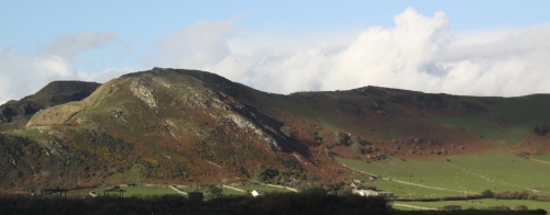
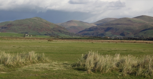
 In Tywyn you can either walk along the sea front on the promenade or on the walkway that runs the length of the promenade at beach level. The path then goes on to the extended promenade lying between residential housing and the sea. This gives you excellent views of the sea, but blocks views of the hills. Part way along is a turn off between the last of the houses and a mobile-home park. This is a small lane that crosses the railway. From there you either walk along the small road that leads to the footbridge or through the fields. Here, there’s nothing but the raised track of the railway to be seen to the west, although the sea can be clearly heard, but the views to the east are absolutely terrific.
We have been incredibly lucky with the weather recently. It has generally been cold, and there have been frosts in the village, but the sunshine so late in the year has been a splendid treat. There were lots of dog walkers out today, everyone making the most of the weather whilst it lasts.


Reblogged this on The Bridgehunter's Chronicles.
LikeLike
Strange how things which you know very well become transformed when photographed in such beautiful light. WGB.
LikeLike
Bridge installed by Jones Brothers not James Brothers
LikeLike
Hi Dai. No idea how that typo slipped through! My thanks for pointing it out. Best, Andie.
LikeLike