Afon Leri from the Panorama Walk behind Aberdovey, showing the railway bridge and the boatyard. The road bridge is between the two, but difficult to see in this photograph.
I have been fascinated by Afon Leri ever since I first visited Aberdovey some twenty years ago. From my living room window it is an unwavering slender scar on the flat landscape to the east of Ynyslas. From up on the hill its opening is clearly perpendicular to the banks of the Dyfi estuary, and one can see the bridges that carry the road and railway over the river towards Ynyslas, next to a small boatyard. The river’s course across this topmost corner of Ceredigion is obviously canalized, an engineered artifice, but why? What was its purpose?

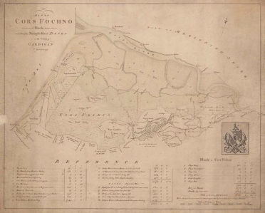
Cors Fochno c.1790, before the route of the Afon Leri was changed. Source: National Library of Wales (where there is a zoomable version of this image)
The Leri rises at Llyn Craig-y-Pistyll below Pumlimon and passes through Talybont, (on the main road between Machynlleth and Aberystwyth) where it meets the Afon Ceulan before flowing behind Borth. The canalized section is 3.35km long and c.35m wide and runs from Ynysfergi in the south to Pont Leri in the north, crossing the low-lying Cors Fochno. Cors Fochno is a Special Area of Conservation and one of the largest remaining examples of a raised peat bog in Britain, which started to form from c.5500BC. Afon Leri now opens out into the Dyfi estuary at Pont Dyfi in Ynyslas. Work on the canalized section had begun by 1790 when the above map was created by T. Lewis, marked as the Pil Newydd.

Excerpt from the above map of Cors Fochno showing the former course of the Afon Leri at far left. The Leri begins at Borth and meanders along the coastline to the west of Cors Fochno up to the point where it emerges into Cardigan Bay at Aberlery (which means the mouth of the Lery). Source: The National Library of Wales (where a zoomable version can be found)
In the early 19th Century local landowners and neighbours Pryse Pryse of Gogerddan and Mathew Davies of Cwmcynfelin were incentivized by the General Enclosure Act of 1801 to reclaim land from the bog in order to develop it for pastoral agrarian use. Land reclamation would require the waterlogged land to be drained. There was little recorded opposition from parishioners, and royal assent was granted on June 22nd 1813. The land surveyor Charles Hassall saw the advantages of enclosing the 5106 acres but warned the landowners against contractors who were either duplicitous or ignorant of the task ahead. His words were almost premonitionary as successive problems plagued the project. Disagreements between land owners, contractors and commissioners, together with serious and ongoing financial problems, caused major delays.
Charles Hassall’s plan was to divert a number of streams that entered the bog to drain away spring floodwaters and build embankments along the Dyfi estuary to prevent salt-water transgressions. He recommended an experienced contractor called Anthony Bower, who was employed in 1815. Bower suggested that using the river Leri to drain water from the land was the most viable solution, but there were problems. The course of the Leri ran along the far western edge of Cors Fochno and emptied a little further up the coast at Aberlery into Cardigan Bay. It was insufficiently deep and fast-moving to serve as a drain for the bog, so Bower suggested that the best solution was to deepen, widen and straighten the river. As Professor Moore-Colyer describes it: “A sluice was to be constructed at the river mouth from which a main drain would run through the centre of the bog. This would be accompanied by a catchwater drain which would follow the course of the Lerry to the foot of the hills and then along the south-eastern boundary of the bog to join the River Cletwr. By this means, Bower believed, water from the hills would be prevented from entering the bog while an embankment on the southern side of the Dyfi would preclude the entry of salt-water.” Sluices and catchwater drains would be employed to control water levels.

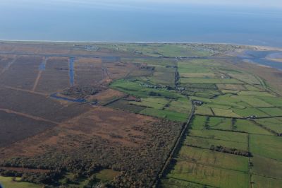
Cors Fochno. Source: Coflein RCAHMW colour oblique photograph of Cors Fochno, Borth Bog, landscape view from east near Ty-hwnt. Taken by Toby Driver on 05/11/2012; Reference AP_2012_4205
In 1815, an alternative proposal was put forward by Griffith Parry of Penmorfa, and which carried an estimated cost of £10,000. Griffith Parry had trained under the great engineer Andrew Rennie on the construction of the London Docks. He also favoured diverting the Leri, but from the west end of Ynys Fergi in a straight line to Pont Afon Leri, and he too believed that deepening, widening and straightening the river was the solution, which he thought should be embanked with clay. In addition, he suggested deepening, widening and embanking surrounding ditches and streams to improve the drainage potential offered by canalizing the Leri.

Gogerddan estate, the seat of Sir Pryse Pryse. Source: Parks&Gardens
Hassall died in 1816 and was replaced by co-commissioners Robert Williams of Bangor and David Joel Jenkins of Lampeter. Williams was staggered by the estimated total cost of £30,000 proposed by Bowers which, with the widening and deepening of other existing drains, would absorb over 1000 acres, and would create a total landmass with a value of only £20,000. Bower and Williams fell out over both this and more personal reasons. For the next two years the parties vied for position, with Jenkins supporting Bower and Williams supporting Parry. Parry’s plan eventually won out. Contractors, to be paid £2500.00 in instalments, were appointed. A final payment of £250.00 was to be withheld until two years after the project was completed, to provide insurance against post-completion problems. Additional costs, including raw materials, were provided by the Aberystwyth Bank after Pryse Pryse of Gogerddan provided security of £6000.00 for the loan, the balance of the cash was raised by selling land on the peripheries of the marsh for over £2340.00 initially. However, financial problems and disputes plagued the drainage scheme, particularly in respect of the contractors not building various elements to specification. Williams resigned and in 1822 Richard Griffiths of Bishop’s Castle, with three successful enclosures under his belt, was appointed in his stead. After the change in commissioner, the appointment of the surveyor Charles Mickleburgh of Montgomery, a new Act of Parliament in 1824, the chaos of further financial difficulties, escalating debts and a court case, the project was eventually completed by 1847, and a small harbour was provided for the local shipbuilding industry. It is difficult to see how the project could ever have seen a return on its investment.
The above map from the 1790s, the Google map to the left and the Ordnance Survey map below show the former and present courses of the river.
A road bridge, Pont Afon Leri, carries the B4353 over the river at Ynys Tachwedd, connecting Ynyslas with the A487. A small boatyard is located on the western side of the road bridge. The Cambrian Coast Line crosses just to its south on a 7-pier railway bridge that was built in 1863. The river is tidal along the length of the cut, and a footbridge over the Leri where the river meets the Wales Coast Path marks the boundary between the tidal cut and the non-tidal river.
The West Wharf boatyard at Pont Afon Leri has a history dating back to the 19th Century. Here’s the description from the Coflein website:
Remains of timber-fronted quay on the west side of the entrance of the river Leri constructed by the railway company. The northern end of the quay frontage is degraded and the quay material has been washed out from behind the piling. The section in front of the boatyard has been repaired and remodelled to accommodate a modern boat lift. Sales particulars dating to 1862 reveal that short section of wharf already existed close the road before the coming of the Welsh Coast Railway. The wharf was part of the land holdings belonging to Issac Ll. Williams Esq under the Geneur’rglyn Inclosure Act. The railway company subsequently undertook the development of the wharf to act as a landing point for a new steamer working the Aberdovey ferry. The paddle steamer ELIZABETH started service on 24 October 1863, the day that the railway line between Aberdovey and Llanwyngwril opened on the northern side of the opened. The vessel was to operate every hour and to charge 6d per head for the crossing. Maintaining the service was extremely difficult as the ELIZABTH was frequently stuck fast on the Dyfi sandbanks. On 5 July 1867, George Owen, the Cambrian railway engineer reported that if the railway line to the north side of the Dyfi could not be fully opened soon, then the wharf would need to be piled. The line subsequently opened in August 1867. The ferry’s use of the West Wharf might have ended then, but the railway inspectors required more work to be undertaken on the tunnels. Whilst passengers were taken round by road, goods continued to be shipped across the Dyfi by the tug JAMES CONLEY. The use of the ELIZABETH on the route was abandoned and the vessel sold in 1869. In 1893, it was proposed that that the barges transhipping slate from the Plynlimon and Hafan Tramway would be charged for using the railway company’s West Wharf. Two years later, in May 1895, Mr I Hughes Jones, owner of the East Wharf sawmill proposed the transfer of the business to the other side of the Leri. This was accomplished soon after April 1896 when a new railway siding was opened to service the transferred sawmill. Also in 1896, is appears that the Hafan Sett Quarry (Plynlimon and Hafan Tramway) were still proposing to use the wharf, as they contacted the railway company with regard to installing a level crossing for the tramway. It is likely that the piling for the wharf was extended around this time to facilitate these new developments. The saw mill continued to occupy the wharfside through to the First World War.
Today the boatyard is still a functioning business, offering boat storage, slipway launching and repairs and has a 16-ton slipway hoist.
 The Ceredigion Coast Path follows part of the course of the canalized section of the river, and intersects with the Wales Coast Path just east of Borth where the canalized stretch of the river begins, as shown on the above map. The Ceredigion Coast Path website has more details, and for those wanting to walk the Leri, there’s a good outline of how it can be approached by Ben Fothergill on the UKRGB website. An official walk across Cors Fochno can be found on the Natural Resources Wales website.

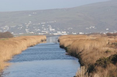
View of the Afon Leri as it approaches the Dyfi estuary. Photograph by Chris Denny (under Creative Commons licence).

Afon Leri from the footbridge where the tidal section of Afon Leri meets the non-tidal section. Photograph by Nigel Brown, used under Creative Commons licence.
Main source for this post and a lot more information, particularly about the financial problems, land sold for financing the drainage, and allotments of land to the poor, with my thanks:
- Plwyf Llangynfelyn, THE ENCLOSURE AND DRAINAGE OF CORS FOCHNO (BORTH BOG), 1813-47 by Professor Moore-Colyer: http://www.llangynfelyn.org/dogfennau/cors_fochno_enclosure.html


Thanks. A great piece and well written.
LikeLike
Very pleased that you liked it.
LikeLike
J.M.Keynes said that if, people knew the real problems that were going to beset investments while bringing them into operation, when they set out, very few investments would ever be undertaken.WGB.
LikeLike
I concluded a long time ago that no-one in the 19th Century would have engaged in half the exciting new ventures into which they sunk their cash if they had had any idea of the apparently infinite number of variables that could sabotage them.
LikeLike