Monthly Archives: October 2018

Castell-y-Bere (1221-1295) in the Dysynni Valley

Ordnance Survey map showing Abergynolwyn, shaded red at bottom right and Castell y Bere in the red square (OS Explorer OL23 Cadair Idris and Llyn Tegid)

Castell-y-Bere is at Grid Reference SH6676908547, overlooking the Dysynni valley near the village of Llanfihangel-y-Pennant.  It is maintained by Cadw (Cadw number ME023 ).  It is a splendid place to visit.  Its remains are substantial, accessed via a short and easy walk, offering spectacularly scenic views over the Dysynni valley that it protected, and is far enough off the beaten track to be wonderfully peaceful.  There are various routes to Castell-y-Bere, but if you are not fond of single track roads, the easiest, and almost certainly the quickest, is to go along the B4405 from Bryncrug to Abergynolwyn, turn left in the middle of the village and follow the brown signs to Castell-y-Bere for about 15 minutes.  For those that don’t know the roads, they are very good quality with plenty of passing places, and the hedges are kept cut right back, but you do have to resign yourself to the fact that you are almost certainly have to do some backing to passing places before you get to your destination, particularly during the summer when the castle has a lot of visitors.  It is very well worth it, however. 

There’s a parking area, and an information sign before you pass through a kissing gate and head along the path.   The walk takes you through trees.  The stone-cut path is well defined but quite uneven.  Although it qualifies as an easy walk and there are no particularly steep bits, there are some fairly sharp drops to the side of the path, so you do have to be sure of your footing. This is even more the case with the castle itself.  There are a number of flights of stairs within the castle, some of which terminate at the edge of a steep drop with no barriers.  If you walk around using a bit of common sense (particularly if you have children in tow) it is perfect, and so much better than the usual ugly tubular metal barriers that disfigure most heritage sites today. 

Castell y Bere aerial photograph with my annotations showing key components of the castle (Source of photograph: Coflein website)

Approaching its original entrance, the castle offers a gloomy and imposing welcome to the building that requires a climb up wooden steps, emulating the original sense of entering into an intimidating stony eyrie,dominated by walls and gate towers, with pits beneath the wooden drawbridges so that when the two drawbridges were raised and each portcullis was dropped there were formidable barriers to entry.  The castle itself provides uninterrupted views over the entire landscape surrounding it, which was strategically invaluable in the 13th century when it was built.  I was expecting a far more dilapidated structure, but what survives is sufficient to make the reconstruction shown on one of the signs traceable on the ground with very little effort, although it helps to have the aerial photograph to refer to.  I have added labels to my photograph of the reconstruction and the Coflein aerial photograph of the castle as it is today, so that my photographs can be related to the original layout of the castle. 

The castle was built in 1221 by Llywelyn ab Iorwerth (also known as Llywelyn Fawr, or the Great, c.1173-1240). Llywelyn, prince of Gwynedd, was a remarkable character, a landmark personality in Welsh history whose reign is characterized by military action to extend his power and attempts at diplomacy to retain it.  It was one of several that he built, including the important castles at Dolwyddelan in southwest Conwy and Dolbadarn at the foot of Snowdon’s Llanberis Pass.

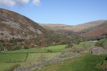
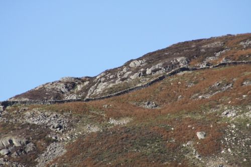
Cattle grazing at the foot of Castell-y-Bere in the Dysynni valley.

The land that Llywelyn chose for his castle was owned by Llywelyn’s illegitimate eldest son Gruffud ab Llywelyn and was taken from him by Llywelyn for the construction of the castle.  The glacial Dysynni valley is wide and flat-based, providing unusually wide tracts of fertile pasture.  Cattle was one of the principal sources of wealth for the Welsh princes in Gwynedd in the 13th Century, and by controlling the pastures surrounding Castell-y-Bere, Llywelyn was able to protect his herds and provide year-round pasture.  Cattle are still herded in the valley, and there were plenty of Welsh black cattle in the fields below the castle when I visited. 

The river Dysynni at the foot of Castell-y-Bere

The castle had political as well as economic value.  From Llywelyn’s point of view, establishing a realm over the entire area of Merionnydd was part of a much more ambitious plan to extend his control over substantial of Wales that were not yet dominated by invaders from England.  Castle building was a relatively new tradition for the Welsh who established undefended courts called llysoedd, which would not have stood up to much in the way of determined attack.  At Dolwyddelan Castle, for example, the remains of the earlier llys survive.  The Norman advances into Wales from the 11th Century put a different complexion on Welsh strategic thinking.  The Norman lords who established their territory in the southeast of Wales, along what is now known as the Welsh Marches, demonstrated how vulnerable the Welsh were to potential hostilities from the east. Timber and earthwork motte and bailey castles were the first defensive structures, but stone castles soon followed.

A photograph of the Cadw sign showing a reconstruction of Castell-y-Bere by Chris Smith. I have added annotations to identify key features of the castle.

View from the middle tower towards the north tower

Llywelyn’s castle was built on a rock outcrop and incorporates much of the bedrock into its construction.  As clearly shown in the aerial photograph from the Coflein website above, it was a contour fort, following the line of the rock.  The castle’s current substantial form reflects various additions to Llywelyn’s original structure.  Its original walls were not as substantial as Edward I’s later additions, and the surviving walls of the original structure demonstrate that this was a much less durable structure than those built by the English.  English castles consisted mainly of straight walls connected by either square or round towers.  In Wales contour forts were common, and apisidal D-shaped towers were characteristic.  Castell-y-Bere has two D-shaped towers, one at each end of the castle, together with a round tower the middle rectangular tower.  K. Steele of the RCAHMW describes how the southernmost of these D-shaped towers differs from typical design “being isolated from the main castle structure, overlooked by the rectangular keep, and accessible from the ground floor, thus rendering it defensively weak.”  The castle was constructed of the ubiquitous local stone.   When the castle was excavated in 1851 some high quality carved stonework was discovered, suggesting that Castell-y-Bere was one of the elaborately decorated of Llywelyn ab Iowerth’s castles. 

The following section looks at the history of Gwynedd up until Castell-y-Bere was abandoned in 1295, for which the following family tree might be of assistance:

Llywelyn ab Iowerth family tree for the period during which Castell-y-Bere was occupied


Llywelyn the Great on his deathbed, with his sons Gruffydd and Dafydd in attendance. By Matthew Paris, in or before 1259.  Source: Wikipedia

Castell-y-Bere remained in Llywelyn’s possession during his lifetime.  Between 1218 and 1240, when Llywelyn ab Iowerth died, peaceful relations were maintained between Llywelyn and Henry III, but the situation deteriorated after his death.  Llywelyn ab Iowerth died in April 1240 of natural causes, leaving two sons, his illegitimate eldest son Gruffud and his legitimate younger son Dafydd by his wife Joan.  Llywelyn had disinherited Gruffud in 1220 to ensure that Dafydd ab Llywelyn would succeed him, an arrangement that was rubber-stamped by the Pope, thanks to the intercedence of Henry III.  When Dafydd ab Llywelyn inherited his father’s seat, Henry re-organized.  Dafydd’s disinherited half brother Gruffud was handed over to Henry for imprisonment in the Tower of London to prevent any attempt to oust Dafydd and destabilize Gwynedd, and Dafydd’s own rights were undermined. Gruffud died at the Tower in an escape attempt in 1244.  Dafydd died of natural causes without an heir in 1246.

Stairs leading up to the rectangular middle tower

The power vacuum allowed Henry III to enter Gwynedd and establish Crown control over the most powerful of the strongholds in Wales, now under the leadership of Owain and Llywelyn ab Gruffudd, two of Gruffud’s sons.  A third brother, Dafydd, was also a beneficiary.  They inherited a Gwynedd under siege, and peace was purchased with the provision of knights and foot soldiers.  Wales remained subjugated until the three brothers came into conflict with each other, Llywelyn ab Gruffudd emerging triumphant and proceeding to take over large tracts of Wales.  From 1258 until 1262, whilst Henry was busy with a rebellion of the barons under Simon de Montfort, he consolidated his new territory, securing its borders.   However, in 1262 he was on the march again, claiming new territories in the far south.  He formed an allegiance with Simon de Montfort in 1265, formalized in the Treaty of Pipton, and although Simon de Montfort was defeated and killed in battle only weeks later, Henry III chose to honour the Pipton agreement in the Treaty of Montgomeryshire in 1267.  The principality of Wales was formed, with Llywelyn ab Gruffudd officially recognized as Prince of Wales, with the right to homage of all the Welsh lords, for which privilege he paid 25,000 marks and became a vasal of the king.

Entrance into the building providing access to the north tower.

Llywelyn ab Gruffudd had made a lot of enemies, particularly in the Marches.  In 1271 he attacked Caerphilly castle and extended his realm even further.  Davies says that his authority “extended from Anglesey to Machen, from the outskirts of Chester to the outskirts of Kidwelly.  He was lord of about three quarters of the surface area of Wales and of as somewhat lower proportion of its inhabitants.  He had perhaps two hundred thousand subjects.” However, the powerful Marcher houses of Clare, Bohun and Mortimer came into direct conflict with Llywelyn, and in 1274 both his brother Dafydd and his chief vassal abandoned him, going to England.  Henry III had died in 1272, but his heir Edward I was away on the Crusade and did not return to claim the crown until August 1274.

One of the rectangular structures in the courtyard

The relationship between Llywelyn and Edward I was strained from the very beginning, caused partly by Llywelyn’s marriage to Elinor, the daughter of Simon de Montfort and by Llywelyn’s refusal to travel to the English court to pay homage to the king.   Edward retaliated by abducting Elinor and in 1276 Llywelyn was labelled a rebel.  Permission was given to the Marcher Lords to reclaim territories that they had lost and the king himself prepared for war against the prince and took an army of 800 knights and 15,000 foot soldiers into Gwynedd.  Llywelyn, cut off from food supplies in Anglesey, submitted in  November 1277.  The Treaty of Aberconwy in 1277 swept away Llywelyn principality in all but name.  Much of eastern Wales was lost to Norman control and castles were established to maintain control in key areas of  Gwynedd, giving Edward nearly complete control by 1280.

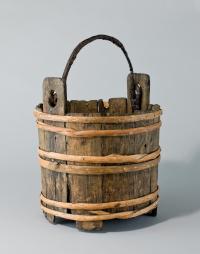
Oak bucket bound with hazel, with hazel pegs, found in the well. Source: National Museum of Wales. 53.123/4.

More uprisings followed, in particular the war of 1282-3 that spread after an attack by Llywelyn’s brother Dafydd ab Gruffudd on Hawarden and Rhuddlan Castles.  Llywelyn ab Gruffud had little choice but to participate but all these attempts were ultimately futile.  Llywelyn ab Gruffud was killed in battle on 11th December in 1282 and Dafydd assumed the title Prince of Wales but by early 1283, Edward I’s vast English army had the Welsh heartland hemmed in.  Dafydd based himself at Dolwyddelan Castle in southwest Conwy whilst the English took Bangor, Caer-yn-Arfon and Harlech, building vast castles as they went.  Castell-y-Bere was the last of the Welsh strongholds to withstand Edward’s armies, falling in April 1283.  Dafydd was captured in June 1283.  He was tortured and put to a grizzly death in Shrewsbury in October 1283, whilst Edward’s programme of castle building continued uninterrupted.

The rubble interior of the walls, in a section probably reinforced by Edward I.

Castell y Bere survived the 1283 battle and under Edward I a number of improvements were made.  It received additional fortifications, in particular thick walls linking the south and middle towers.  The large rectangular keep overlies a rock-cut ditch suggesting that it had the adjoining D-shaped tower are additions to the original castle may be from this time.  Edward wanted to establish an English borough and a charter was granted, extending from Abermaw to the Dyfi, but the site never prospered.  In 1284 the Statute of Wales, or the Statute of Rhuddlan, was initiated.  The three counties of Anglesey, Caernarfon and Merioneth were created and placed under the management of English sheriffs, effectively splitting Gwynedd into manageable administrative chunks and ending the dreams of Llywelyn ab Iorwerth.  A last ditch Welsh uprising during 1294-5 ended Castell-y-Bere.  Madog ab Llywelyn attempted to take the castle from the English.  He failed, but the castle was very badly damaged in the process and was abandoned.  The 1850 excavations found extensive charcoal, suggesting that it may have been burned.

View along the castle towards the pastures in the Dysynni valley

The 1850 clearance of the site produced some other interesting discoveries.  One of the excavators W.W.E Wynne describes opening the excavations in an article in Archaeologia Cambrensis “in the year 1850, we commenced our excavations, not with the expectation of discovering any object of superior interest, but for the purpose of tracing as accurately as possible the circuit of the walls and making a plan of the building.”  It was during these excavations that the ornamental stonework and other masonry fragments were found. Other items discovered were pieces of chain-mail, corroded arrowheads, part of a crossbow, several knives, one retaining a wooden handle, part of a bone comb and large amounts of pottery, mainly glazed in green or olive.  Animal bones bearing signs of butchery included roe deer and boar. 

Plate from Wynne’s 1861 report of the 1850 excavations.

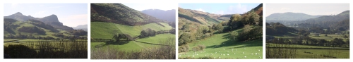
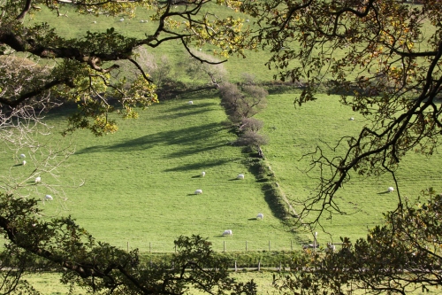
Views from Castell-y-Bere over the pastures that are used today for grazing cattle and sheep


References:

Stonework from Castell-y-Bere, held at Criccieth Castle Museum. Source: Hchc2009 under CC-BY-SA-3.0 licence

Avent, R. 2010. Dolwyddelan Castle, Dolbadarn Castle, Castell y Bere. Cadw

Davies, J. 2007.  A History of Wales. Penguin

Glamorgan-Gwent Archaeological Trust http://www.gatehouse-gazetteer.info/Welshsites/510.html

Jenkins, G.H. 2007. A Concise History of Wales. Cambridge University Press

Steele, K. 2008.  Castell-y-Bere. RCAHMW, 4 November 2008 http://www.coflein.gov.uk/en/site/93719/details/castell-y-bere.

Wynne, W.W.E., 1861. Castell y Bere, Merionethshire.  Archaeologia Cambrensis Vol. 16 p. 105-10 https://archive.org/stream/archaeologiacam07moorgoog#page/n121/mode/1up


Walk: Autumn scenery around Tal y LLyn and Castell-y-Bere on a perfect sunny day

My visit to Castell-y-Bere on Monday, via a very short detour to Tal-y-Llyn, was a perfect cocktail of lovely sun-kissed scenery, well maintained heritage and a clump of fascinating education all in one visit.  What’s not to love?  If you wake up to a glorious autumnal day like this one, why not consider sorting out all your bits and pieces in the morning and then hop into the car and go to Castell-y-Bere for an hour or two.  It’s the perfect excuse for a tiny holiday-like experience.

I have written up the castle itself and its history on another post, here, but here are some photographs of the surrounding scenery. With the sun reflecting off fast-moving streams, filtering through the reds, oranges and yellows of autumn leaves and lighting up the stunningly bright greens of the grass, and the rust-coloured foliage on the hillsides it was just about the most idyllic day I have had at Aberdovey so far.  I spent most of last week in London.  It was super to visit my former home, but the contrast was unbelievable.  The feeling today of being let loose on life was exceptional.

Desert boots turn out to be surprisingly well suited to Welsh footpaths. My other hiking boots have not yet emerged from the packing boxes, but these did fine.


A brief history of 1-3 Penhelig Lodge Cottages, Penhelig

One of the oldest 19th Century buildings remaining in Aberdovey, resembling earlier 18th Century vernacular architecture, is the lovely little row of homes now known as Penhelig Lodge, on the left after you pass the Penhelig Arms public house and walk under the railway bridge on the way out of Aberdovey towards Machynlleth (grid reference SN6211696171).  It all looks to be in excellent condition, much-loved, and has been grade 2 listed since 1994 (Cadw 14963).

Penhelig Lodge, both around 1837. Source: Hugh M. Lewis M.B.E. Aberdyfi. A Glimpse of the Past.

Engravings of Penhelig Lodge survive dating to around 1837, some twenty five years years before the coming of the railway, which transformed both the appearance and the economy of Aberdovey and Penhelig.  Hugh M. Lewis says that it was originally fisherman’s cottages.  When it was built it comprised three terraced houses.  The engravings show a low, long two storey building with four chimneys, the lower storey protruding out onto the very edge of the road itself.  Made of local stone with a slate roof, It is thought that the three small windows retained in the central terrace  were the original design, the middle one set immediately over the front door, whereas the more obviously Georgian taller sash windows in the flanking homes that reach into the eaves were later 19th Century replacements.   There appear to have been three of these taller windows on the left hand building (no.1), but the central one was bricked up at some time in the past, perhaps to avoid the 1696-1851 window tax.  No.3, at the right end only ever seems to have had two.  Looking at the 1837 engraving, there is a clear delineation between no.2 and no.3, perhaps suggesting that no.3 was in fact a later addition and that the original building only consisted of the two homes. This needs checking against other engravings of this part of Penhelig, if there area any.  At this time Aberdovey and Penhelig were closely related but still maintained their own identities.  The three terraced houses overlooked a sloping beach that became a shipyard.  The beach came right up to the road, which was only changed when work on the railway began in the early 1860s.

In 1844 the leader of the local branch of Plymouth Brethren, Dr John Pughe (Ioan ap Hu Feddyg), came to stay in the terrace, convenient for assembling in their chapel on the beach, the former bath house, which in turn became the Aberdyfi Literary Institute in 1882.  I’ll add more about Dr John Pughe when I have found out more about him.

Penhelig Lodge is to the left of the railway track, in about 1865, now separated from the sea by the railway and the newly built Penhelig Terrace, which is end on in this photograph.  Source:  Hugh M. Lewis, Pages of Time.

The arrival of the railway in the late 1850s and early 1860s, eventually opening fully in 1867, cut Penhelig Lodge off from the beach and the shipyard that operated there, inserting a raised railway embankment between the road and the beach.  On the other side of the railway a new set of houses began to be built in 1860 on part of the shipyard and using quarrying refuse from the tunnelling for the railway as a base.  This new row of houses is now known as Penhelig Terrace and the shipbuilding yard became a ship repair yard instead, a common fate for shipbuilding premises from the early 1850s onwards, as steam took over from sail and rail took over from shipping.  If you click on the photograph and look at Penhelig Lodge, you can see that the upper storey of Penhelig Lodge has had half-timbering applied to the outside walls, giving it a mock Tudor appearance, presumably to make it look older than it actually is.  If you look at the railway tracks, you will not that there is no station here at this stage.  Penhelig station was only added in 1933.

In 1882 the terrace became an exclusive boarding school for young ladies, set up and run by Mrs Sarah Scott.  In his booklet Pages of Time Hugh M. Lewis quotes its mission statement, which says that its aim was to “impart sufficient culture, etiquette and deportment to the public to enable them to assume their proper places in society.”  Presumably in such a remote area its emphasis there was little opportunity to but these skills into practice locally.  The school apparently endured for two decades and there is a memorial to Mrs Scott in St Peter’s Church.   I will add a photograph of this when I have had chance to visit the church.

Penhelig Lodge in the early 20th Century. Source: Coflein. “Digitised postcard image of 1, 2 and 3 Penhelig Lodge, Aberdovey, G. Williams, London House, Aberdovey. Produced by Parks and Gardens Data Services, from an original item in the Peter Davis Collection at Parks and Gardens UK. We hold only web-resolution images of this collection, suitable for viewing on screen and for research purposes only.”

In the early 20th Century it became the lodge for Plas Penhelyg (Penhelig House), built in 1903-6, and was occupied by the head coachman and head gardner.   Thanks to Dai and Helen Williams for telling me that Plas Penhelyg used to be a hotel but is now in private ownership.  This photograph shows it in the early 20th Century with the half-timbering still in place.  The extension to no.1 was already added in the above 1837 engraving, but appears to have had a prominent bay window added, which survives today.

Today 1, 2 and 3 Penhelig Lodge has been restored to three terraced houses.  It is lucky to have maintained much of its original appearance, although as discussed above the windows have clearly been altered over the years.  In at least one of the houses, no.3 Penhelig Lodge, the room used today as a kitchen has natural bedrock exposed as part of the rear wall of the building.

The Coflein website describes its current appearance as follows:

The terrace is two storeys, with a band course between floors and a slate roof with 4 small rendered chimneys. The left house has two windows with small-pane sashes set at the eaves. The central house has, on the first floor, three 9-pane hornless sash windows; and a central doorway flanked by small-pane sash windows. The right house has two windows with first floor small-pane sashes set at eaves; the ground floor has 2 tripartite casement windows to the front. To rear of the left house, there is an extension with a gabled half-timbered oriel window.

Horns, if you are unfamiliar with the term, are the bits of wood that extend down from the top piece of many two-part Georgian sash windows.

It bears a remarkable resemblance to Yr Ysgwrn, farmhouse and home to Welsh poet Hedd Wyn (the bardic name of Ellis Humphrey), a mile to the east of Trawsfynydd.  It is now owned by the Snowdonia National Park and preserves the interior as a museum.  You can see a photograph here.

An advert for the sale of 3 Penhelig Lodge on 15th November 2018 shows a view of the house and the interior with the exposed bedrock in the kitchen, which is absolutely superb.

Estate Agent Advert for 3 Penhelig Lodge in Cambrian News 15/11/2018

If you know more about this building, wish to make corrections, or have photographs that you would not mind sharing, I would love to hear from you.

References:

Aberdyfi Chamber of Trade 2018.  Aberdyfi Aberdovey Walks.
British Listed Buildings website
Coflein (National Monuments Record of Wales) website
Gwynedd Archaeological Trust 2007.  Ports and Harbours of Gwynedd: Aberdyfi. A Threat Related Assessment.  GAT Project  No.1824, Report No.671.1, April 2007
Gwynedd Archaeological Trust 2011.  Conservation Area Appraisal: Aberdyfi, Gwynedd. GAT Project  No.2155, Report No.956, June 2007
Lewis, H.M. 1989.  Pages of Time.
Lewis, H.M. Aberdyfi. n.d. A Glimpse of the Past.

A three day fish-fest thanks to Dai’s Shed and my freezer

On Wednesday I floured and pan-fried a terrific chunk of Dai’s seabass that I had in the freezer from a couple of weeks ago. Seabass freezes beautifully for short periods and this was a gorgeous piece of fish, in terms of both texture and flavour.  I served it very simply with a sauce made of capers, diced tomato, finely diced banana shallot and finely chopped herbs (Thai basil, thyme, ordinary basil, parsley, oregano, lovage and just a little mint) in virgin olive oil and lemon juice, served with griddled courgette discs, sautéed potatoes and accompanied by lemon slices. It is super to be able to use herbs from the garden whilst they last, and the Thai basil, a new addition to my outdoor herb collection, came over particularly well.  It is amazing how long the herbs are lasting – I was expecting most of them to be well on their way out by now.  I will particularly miss the lovage, which I use in huge quantities in salad and fish sauces, as it is simply unavailable even in big supermarkets.

Yesterday the flavours in my fish tagine were a bit more complicated but it was also a doddle to prepare.  Again from the freezer, I had a piece of huss that I cut into chunks, that I marinated in a mix of fresh coriander from my garden, paprika, cumin, cayenne, lemon and olive oil.  This was then cooked, complete with the marinade, in puréed fresh tomato, cumin, garlic, onion, with fresh chillis and parsley (both from my garden), grated carrot, preserved lemons and okra, with a little home made fish stock.  I sprinkled mint over the top and served it with lime and coriander cous cous.  The latter was a cheat – a pack from Ainsley Harriott, but it is so good that I never feel guilty about not making it myself.  Huss is brilliant for this type of cooking because it retains its shape, and has enough flavour of its own to stand up to all the herbs and spices.  Like the seabass, it is a good choice for the freezer, and it is blissfully easy to fillet.  I make the tomato, onion and garlic base in huge batches for the freezer, partly for convenience but mainly because I absolutely detest peeling tomatoes and prefer to confine the suffering to single large sessions.  As I really don’t like the harsh sweetness of tinned toms (I’m a bit of a fussy eater) it is seriously worth the effort.

Today I was at the excellent community lunch, about which more on a future post, so there was no need for an evening meal, but I used some fish stock that I made yesterday from a freezer bag of fish bits (heads, tails, bones etc) left over from preparing and filleting fish to make myself a fish soup.  To give it a bit of body and flavour I recruited some onions, some fennel that needed using up, garlic cloves, chilli from the garden and skinned fresh toms, all whizzed up in the blender.  In a somewhat extravagant mood I lobbed in rather a lot of saffron for that extra bit of Mediterranean luxury, seasoned it with sea salt and pepper and sprinkled over a bit of coarsely chopped parsley.  It was supposed to be basil but I wasn’t about to go outside to pick some in pouring rain and a gale (thanks Storm Callum) when I had some parsley in the fridge!  Grabbed a spoon and bowl and it was Job done. There was loads left over for the freezer, a blessed fall-back for when I don’t feel like cooking.

A proper seaside walk – the beach, the sea, the waves, sun and even a sandcastle

Sunshine, sand, sea and almost no-one on the beach but me.  Idyllic.  When I woke up this morning it was cold and grey, but by noon the day had clearly decided to fall in line with the weather forecast and blossomed into a glorious autumn afternoon.  I had stuff I needed to do but I was done by 2pm and drove to the lay-by on the road to Tywyn, opposite the line of houses on the other side of the Trefeddian Hotel.   A path crosses the golf course, wends its way through the dunes and drops you by the Second World War pillbox.  From there Tywyn is clearly visible in the distance.  The tide was out, just on the turn, so it took a couple of minutes to reach the water’s edge, although the roar from the waves had been clearly audible from the road.

The beach was spectacular, the damp sand reflecting blue sky and white clouds, with deep dips holding pools of water like liquid silver and white-topped blue waves thundering as crests broke, chaotic shapes forming and reforming.   The main strandline was up by the dunes, clumps of dark weed, but there were long strands of weed shimmering in the sunshine, some floating in pools some strewn along the sand.  I took a few photos and a couple of videos as I walked towards Tywyn, got wet feet, and generally had a great time.  It really was a spectacular afternoon.  A lady on the checkout at the Co-op in Tywyn, who also moved here from London, told me that the novelty lasted six months with her, but I really don’t see it ever wearing off for me.  Mind, I haven’t survived an Aberdovey winter yet.

Crossing the sand dunes.  Close to the beach they are stablized by marram grass.

The first and last photos are burnet roses, small and delicate, that are usually found in sand dunes. The pink petals belong to a blackberry bramble and the blue berries are blackthorn, also common in sand dunes.

Lovely shapes and light on the wet sand

Ecofacts. The shells are a limpit with a beautiful yellow shell, an elegant variegated scallop, a saddle oyster and a purple-black common muscle. An articulated crab claw has become detached from its owner. This was the first cuttlefish bone that I have found on the Aberdovey beach, beautifully laminated. Within the calcium-rich shell there are chambers that that fill with gas or water allowing the cuttlefish to rise or sink.

Here are two of the videos.  I am still trying to get the hang of this whole video thing.  The autofocus on the little camera that I use for video was having trouble today, unsurprisingly, and it was having trouble with the shifting light too.  And of course, it was absolutely not all the camera’s fault that these are anything but perfect.  This was my first time trying to video the sea, and the learning curve shows rather acutely!  Huge fun though, and I’ll get there eventually.

The lay-by to park for this stroll on the beach is at The Crossing, just where the A493 goes around a slow but definitive bend. It is opposite a very fine terrace of tall houses. The footpath is a track on the left of the lay-by and takes you over two stiles across the railway. You then cross the golf course to walk along the path through the dunes and down on to the beach by the Second World War pillbox, marked on the above map with a red rectangle.


Speed-eating: close-up of a blue tit feeding

The robin and the sparrows are quite happy to feed close to the house, but the coal tits, great tits and blue tits are much more cautious, except for one individual which has decided that the fat balls are worth the risk.   In this short video, only a few feet from the camera, you can clearly see the blue tit digging into the fat balls through the holes in the feeder.  I have never seen food go down so quickly – amazed that he/she didn’t get hiccoughs!  The avian equivalent of fast food.  Don’t be put off by the fuzzy preview on the image below – it’s all super-sharp.


Low Tide at 1356 on Saturday 6th October 2018

Low tide yesterday was at 1344 and this shows it just a few minutes afterwards at 1356.  At that time it was only at 1.55m above chart datum (data from tidetables.org.uk) and was one of the lowest tides that I have noticed since I arrived.  The kayaks really put it into perspective, showing how narrow the channel had become.


For comparison, the following high tide was at 1902, at 4.60m.  It was getting dark by 1902 so this photo was taken at 1711, as the tide was coming in, at c.3.80m.