Category Archives: River Dyfi

New book: Richard Mayou, “The Dyfi Estuary – An Illustrated History”

I am very excited to have taken receipt today of Richard Mayou’s new book “The Dyfi Estuary – An Illustrated History”, just published by The Machynlleth Tabernacle Trust.  I will report more when I have done more than devour the feast of lovely photographs, but for anyone wanting to secure a copy, it is available from the Machynlleth MOMA (Museum of Modern Art) at https://moma.cymru/en/product-category/books/.  There are two versions of the same book, one in English and one in Welsh.  Here’s the preview from the back cover:

The Dyfi estuary looks peaceful and unchanging, but the book tells
a different and dramatic story.  There have been armies, great estates, a centre
of seaborne trade, a great woollen industry, cattle droving and fishing of
salmon and herring and internationally renowned mines and quarries.
Now its post-industrial landscape is a place of
sheep-farming, conservation and tourism.

I’m chuffed to bits that this blog is listed in the further reading section.


A first-time walk from Happy Valley towards the Dysynni

I hadn’t seen my friend Caroline for ages, so it was great to do one of our social distancing walks, and one that was new to me, taking in a tiny prehistoric stone circle.  The track is marked on the OS map as a “byway open to all traffic” and follows the line of the Nany Braich-y-rhiw stream, at a higher level.  The views were as spectacular as they always are when you get on to the higher ground in these parts, into the Dyfi valley at the start of the walk, into Happy Valley, and eventually, ahead into the Dysynni valley.  The track is very deep and carved out of the bedrock in places, just like the Aberdovey estuary’s “Roman Road,” which is actually thought to date to the 1820s.  We drove to the point of departure in separate cars, parking on verges, as it is a long hike to reach the start from Aberdovey, and then a long hike in its own right.  On this occasion it was a there-and-back walk rather than a circular one, but just as good because the views are different in each direction.  It was 19th September and the weather was in our favour.

On the map below I’ve marked the starting point in red, and have put blue dot where another path descends into the valley, more or less opposite the Bearded Lake.  Although we carried on along the main track, you can make a lengthy circular walk if you take the path into Happy Valley, and it would probably be easiest to park in the official Happy Valley car park if you are going to do that (which also serves as the car park for those wanting to walk up to the Bearded Lake).

It’s an easy walk if you have good footwear, with a good track and no very steep gradients.  It should also be avoided in wet weather, or at least go in heavy duty footwear.  It had been very dry for the previous week, but we still ended up having to walk off the path in certain places as it was swamped with mud, and was often marshy either side of the path.  There were several points at which we had to ford fairly wide streams, two of which are marked on the map as fords. It was very windy even on a sunny day, so head gear would be a sensible precaution.  The only cloud on the horizon was that at weekends it is used by trial bikers, travelling at speed, with precious little care for any walkers who might be round the next corner.  Thanks to the noisy engines, you can hear them coming and get out of the way, but I recommend that you avoid walking there at weekends.

The stone circle is a little way along the path, up to the right, just a few seconds to reach it from the footpath.


The walk offers beautiful views over Happy Valley and the hills beyond.

Watch out for the Bearded Lake on the other side of the valley to the left, on this occasion glistening in the sun like a silver mirror.  I’ve written about the legends associated with the lake on an earlier post.

We walked past the footpath down into Happy Valley, which would have formed a circular walk, and headed instead for the views ahead, which offer an unexpected sight of the Dysynni valley.

As it descends towards the Dysynni, the track meets the stream, Nant Braich-y-rhiw.

At this point, descending towards the Dysynni valley, we turned back towards the cars, but if you carry on you reach a single-track B-road that crosses the Talyllyn railway at Rhyd-yr-onen and finishes in Bryncrug.  It was an equally beautiful walk on the return leg.  I suppose it was about an hour and half in each direction, pausing to enjoy the views with a picnic.


A favourite walk to the Bearded Lake (Llyn Barfog) above the Dyfi estuary

It was supposed to be a hillfort visit, but I was fed up of driving to where I wanted to walk, so two weeks ago I did a route that I could do by leaving the house on foot, taking the Panorama walk to the lake and back again, which takes a route across the ridge.  I had planned to take the longer route via Happy Valley, but was tired after an iffy night, so took the shorter route, which also allowed me to get a look at the rear end of Foel Caethle, a hillfort the lies between Tywyn and Aberdovey, from a slightly higher viewpoint than the peak of Caethle itself.

If you haven’t done it before, it’s super-easy to follow the Panorama on the Ordnance Survey map.  You pass through a number of gates (five in total, I think, but more if you choose not to balance your way across cattle grids) so you will need to take hand gel and/or gloves.  Just walk up Copper Hill Street from Chapel Square, and after about five minutes take the right turn into Mynydd Isaf, which is a development of 1960s bungalows.  Follow this all the way to the top and at the crossroads go left.  Keep an eye out in the verges too, for wild flowers and small butterflies.  The harebells are particularly worth seeing – more prolific in August but with many still left in September.  The tormentil is prolific at this time of year, and the last of the little cornflower-blue Sheep’s-bit are still around.  There were lots of red admiral butterflies around, although none of them were obliging enough to settle to have their portraits taken.

This takes you uphill, and you are instantly in the countryside, passing a farm on your right, with views over Aberdovey to your left.  Just keep walking, not forgetting to turn round and see the gorgeous views over the estuary as you go higher, until you reach a right turn, with the chalet park ahead of you.  It’s about an hour and 15 minutes from here to the fork for Llyn Barfog (and the same on the return leg), with gorgeous views over Happy Valley and the hills to the left, and some views over the glistening estuary to the right, which looks completely different depending on whether the tide is in or out.

The tarmac eventually runs out at the farm, at which point you pass through two gates and onto a deeply incised farm track with a drystone wall on your right and views now mainly over the estuary, with a slope of gorse and heather rising to your left.

You may want to pause and puzzle over Arthur’s Stone, marked with a dignified slate rectangle, a bit like a headstone, inscribed with the words Carn March Arthur (the stone of Arthur’s horse, which in some legends is called Llamrai).  It has a role in the slaying of the story of the monster, called the afanc, that lived in the lake, which I’ve summarized below, and what you’re looking for is the hoof imprint of the horse of King Arthur.  Good luck with that.

Carrying on a short way downhill, with views over the hills ahead, an array of colours as they fade into the distance, you go through an open gate (shown right) and the footpath for Llyn Barfog is just on the left.  It is easily missed – there is a wooden stake marking it (shown immediately below), but no signpost.  It is, however, quite well worn so if you keep an eye open you should be okay.  This takes you round the foot of a small hill rise and leads you directly to the lake, about a 10 minute walk.  I sometimes follow the sheep tracks to the top of the rise instead and then make my own way down, because the view down onto the lake is great, but the going isn’t easy – the sheep tracks are very narrow and the surface all around consists of big, dense clumps of heather that are not easy to walk between.

However you arrive at it, the lake always manages to be a bit of a surprise, so high up and so intensely blue.  Each time I visit, I half expect it to have vanished.  I’ve sadly never managed to catch it when the water lilies and other water flowers are in bloom, but today the lily pads were deeply green against the blue water and gave it a rather exotic feel, and the water glowed and sparkled in the sunlight.  I sat on a handy outcrop of quartzite for a while to enjoy the views and the silence.

The name “bearded” is thought to relate to the vegetation around its edges.  Unlike Arthur’s horse’s stone, one really could imagine this being a source of myth and legend, and indeed, there are at least two.  One concerns the water monster known as the afanc, which is associated with other lakes too, a legend that eventually had an Arthurian spin on it.  Here’s the main thrust of it.  The afanc was the cause of flooding and other damage to good land.  In some versions he lives in a cave and slays three princes a day who come to kill him, but they are resurrected, and the cycle repeats.  In the case of Llyn Barfog, the afanc must be lured from the water by a heroic figure who will finish him off, and this hero eventually becomes Arthur.  Arthur and his horse pull the monster from the lake, finishing it off, and one of the horse’s hooves leaves its imprint in the Carn March Arthur.  See more on the Coflein website, where you can read a Llyn Barfog legend of green-clad fairies, two cows in love and a greedy farmer.

The return trip is just as good.  The wind had got up a bit, so it was nowhere near as hot.  On the entire walk I saw only six people, three separate couples.   That surprised me,because at this time of year it is usually quite popular with walkers.


Lovely cloud formation low over the Dyfi estuary

Last Thursday we were treated to a remarkable sight over the Dyfi estuary – a bank of pure white cloud that sat over Ynyslas and moved forward towards the water, eventually dispersing into wispy strands before clearing completely.

Dyfi National Nature Reserve booklet

Whilst sorting out some stuff on one of my bookcases I found a bilingual leaflet/booklet produced by Natural Resources Wales giving details of the Dyfi National Nature Reserve, including walks and seasonal highlights.  It was free of charge, and I think I picked it up at the Ynyslas Visitor Centre.  The Dyfi National Nature Reserve includes the Ynyslas sand dunes, the saltmarsh, Cors Fochno, the 5000 year old peat bog and a wide range of wildlife.  It’s an excellent little publication, which I have scanned so that you can download it here.  The following shows the front and back cover, and the fold-out map.

The map shows the village of Furnace on the A487, which has the excellent and well explained remains of the Dyfi royal silver mint and charcoal blast furnace.  I’ve posted about it on the blog here, if you are interested in combining a visit to it with a Dyfi National Nature Reserve walk.

Dai’s Shed – Open and selling seafood on the Aberdovey wharf!

Dai’s shed is open on the wharf, selling freshly caught seafood on Thursdays, Fridays and Saturdays from 11am – 2pm.  So miffed that I didn’t know, because they have had flounder in, and had just sold out when I turned up!  But I came away with a frozen dressed crab, so it was still a splendid result.   Fresh live lobster, and fresh dressed lobster are also available.  Lockdown just got a lot fishier.

This card from “Dai’s Shed,” selling superb locally caught seafood from Easter until Autumn, shows Dai’s fishing boat at low tide against a backdrop of the hills over the estuary.


The Loss of the 1857 Aberdovey Schooner Frances Poole


There are a lot of newspaper reports about groundings, collisions and total losses in 19th Century newspapers centred on north and mid Wales.  I stumbled across this story about the loss of the Aberdovey-built schooner Frances Poole whilst looking for something else, and it was less the loss of the ship and crew that startled me than the remarkable brevity of the report.  The story was published in the 27th March 1869 edition of the Cambrian News.  It is a nod at a total loss, and in its very brevity is a comment on how regularly coastal ships foundered with partial or total fatalities.  Ship accidents and tragedies were a dreadfully common occurrence.

I went back through various sources to find out more about the ship, her background and her crew.  The Frances Poole was built in Aberdovey and her senior officers lived in Aberdovey.  There is nothing that particularly stands out about the ship.  She was an average cargo carrying ship going about here daily tasks when she fell foul of a gale on the Cornish coastline when she was just 12 years old.  A reliable ship that made several voyages to eastern Spain, she was well-built, admired for her speed and generally well thought of.

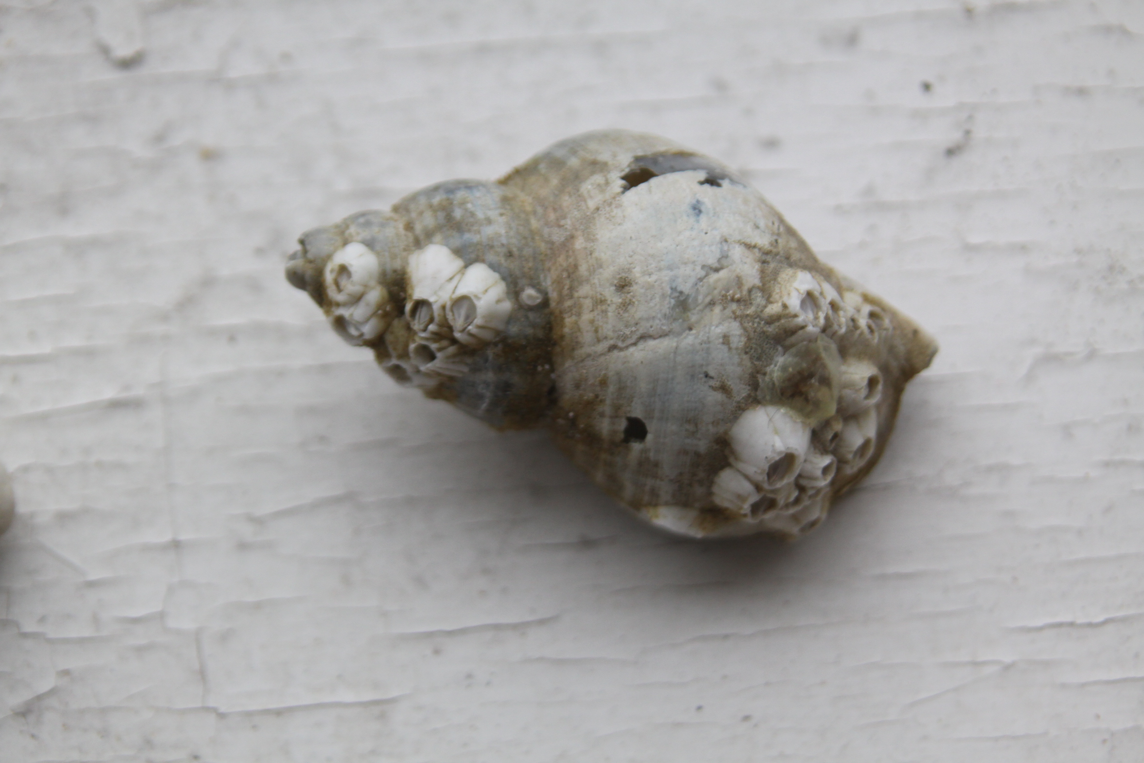
The John Jones schooner Catherine. Source: Lloyd 1996, volume II

Frances Poole was a, 84-ton schooner built in Aberdovey in 1857 by John Jones.  She was 75ft long with a 20ft beam, fitted with the figurehead of a woman.  Sadly there is no known picture of her, or of her builder John Jones.  The photograph to the left is another John Jones schooner, the Catherine Jones, 76 tons (8 tons lighter than Frances Poole and built 12 years later), but gives an idea of the type of schooners that John Jones built.

John Jones, “Jac y Taeth” was the most prolific of the Aberdovey shipbuilders.  He probably settled in Aberdovey in the 1840s, having been born in Llanfihangel-y-Traethau in around 1816, and was accompanied by his wife Catherine with whom he had seven children.  Lewis Lloyd  suggests that John Jones had probably served an apprenticeship in Porthmadog as a ship carpenter.  All his ships were built on the river Dyfi, most at Aberdovey and some at Llyn Bwtri near Pennal and at Derwenlas.  He often had more than one vessel on the go at once, and Lloyd says that he laid 16 keels between 1857 and 1864, and some 29 throughout his shipbuilding career, specializing in schooners.  Of these the smallest of his schooners was c.45 tons and the largest were Sarah 106 tons and Eliza Jane, 131 tons, which seems to have been converted into a schooner.  He also built a small smack, Morben 28 tons, a 209 ton brigantine Rebecca, and the 258 barque Mary Evans, amongst others.  He was clearly a man who could put his skills to whatever type of sailing ship was needed, small or large.  Two of his sons, Robert and Evan, also entered the business.  As shipbuilding declined he seems to have shifted from building ships to repairing them instead, a common solution for former shipbuilders faced with the difficulties of the shipbuilding industry towards the end of the 19th Century.

Frances Poole was registered in Aberystwyth, no.17350.  Her managing owner, the agent for the shareholders and responsible for overseeing it as a business venture, was David Jones, resident in Machynlleth. The first shareholders for the ship (listed in Lloyd 1996, p.143) are as follows:

  • 16 shares – Griffith Jones, Farmer, County of Merioneth
  • 8 shares – Master William Lewis, Master Mariner (no certificate), Aberdovey
  • 8 shares – John Lewis, Master Mariner, Aberdovey
  • 6 shares – Mary Brees, spinster and shopkeeper (owned shares in a number of ships), Machynlleth
  • 4 shares – David Jones, clerk and managing owner of the Frances Poole, Machynlleth
  • 4 shares – Edward Morgans, farmer, County Merioneth
  • 4 shares – William Jones, coal merchant, Machynlleth
  • 4 shares – Robert Williams, grocer, Aberdovey
  • 4 shares – John Jones, flour dealer, Machynlleth
  • 4 shares – Thomas Edwards, farmer, Cardigan
  • 2 shares – Thomas Llywelyn, clerk, Machynlleth

As Lloyd points out, the large number of shareholders from Machynlleth is an indication of how important the commercial ties between Machynlleth and Aberdovey were.  It is notable that John Jones, the builder, is not amongst the shareholders.  Unlike many shipbuilders, he never owned shares in the ships that he built.

The Frances Poole‘s master since the date of her launch was one of her owners, Captain William Lewis (1827-1863), who was born in Borth in 1827 but had moved to Aberdovey.  She was built partly to meet the needs of the slate trade.  Slate was an important material in rapidly expanding industrial areas, and neighbouring Tywyn and, further afield, Corris, had an excellent supply.  The slate was transported to Aberdovey’s wharf, and was loaded onto small coastal ships, offloaded at suitable ports for carriage inland.  Having dropped off her slate, often in London, Frances Poole then loaded cargoes at those ports for other destinations before returning to Aberdovey.  When she was unable to source an ongoing cargo, she headed to the next port that offered the best potential for a return cargo, known as being “in ballast.”  Although she was initially destined for coast-hugging work, after a decade of coastal work, she began to engage in the Spanish and French trades, suggesting that she was a very robust vessel.

Crew records sourced by Alan Jones (2010, p.52-68) for the year 24th July 1861-17th July 1862 provide a useful insight into the sort of distances that the Frances Poole covered:

The destinations of the Frances Poole in 1861-1862. Source: My Welsh Ancestry, John Jenkins.

  • July 1861, Aberdovey to London with slate
  • London to St Valery at the mouth of the river Somme, unknown cargo
  • In ballast (meaning no cargo loaded) back to Newport
  • Newport to Aberdovey, probably with coal
  • Aberdovey to London with slate
  • London to Penzance, unknown cargo
  • Penzance to Newport, in ballast
  • Newport to Aberdovey, arriving December 1861
  • 11 February 1862, Aberdovey to Bangor
  • Bangor to London
  • London to Whitehaven
  • Whitehaven to Newport by 29th April 1862
  • 2nd May 1862, Newport to Aberdovey
  • Aberdovey to London
  • London to Whitehaven
  • Whitehaven to London by 17th July 1862

The crew for these voyages consisted of:

  • The Master (no certificate), Captain William Lewis of Borth, resident in Aberdovey
  • The Mate, Thomas Jones, age 29, of Borth
  • AB (able-bodied) seaman John Davies, age 20, of Aberdovey
  • OS (ordinary seaman) John Jenkins, age 21, of Borth
  • Ship’s boy Thomas Edwards of Borth, age 16, on his first voyage

The seaside town of Borth was not a trading port in its own right, although it had a long fishing tradition, but it supplied a lot of the Aberdovey trading coasters with crew, and several of the Aberdovey-based Masters came from Borth, much like Captain Williams. Captain Williams sailed with the ship until his death on board at Newport in October 1863 from “a rupture of a blood vessel” at the age of 36.

Captain Williams was replaced the next day by Captain John Evans, aged 43, who held a Certificate of Service (no. C.S. 701507), a native of Bangor but resident in Aberdovey, and the Master of Jane Gwynne (also built by John Jones, and of a similar size).  Under Captain Evans, the ship engaged in the Spanish trades, calling at Valencia, Lloret de Mar, Malaga, Tarragona and other ports, sailing mainly from Newcastle.  She also visited French ports, including Boulogne, Dunkirk, Dieppe, Quimper and St Valery.

Captain Evans was succeeded by John Williams (no certificate) from Aberdovey, by 1867.  From then on here trips were mainly along the British coastline, again, but included at least one visit to St Valery.

Captain John Williams was in turn succeeded as Master by John Morris, aged 35, of Aberdovey in 1868 (no certificate), the same year in which he became managing owner for the Frances Poole.  He had formerly sailed on Mountain Maid, and took on William Morris, aged 33, as Mate, also formerly on Mountain Maid.  By 1869 he had been replaced by Hugh Pugh of Aberdovey, having previously served on the Mary Jane. A common port of call was Runcorn.

The Frances Poole was still sailing and trading until March 1869.  The Cambrian News and Merionethshire Standard reported on the loss on 27th March 1869 (the short report is shown on the left).  Frances Poole had set out from Cork, heading from Liverpool, then Runcorn before heading down to Faversham with a mixed cargo.  She was wrecked during a gale against the rocks of “Godvery” (probably Godfrevy) Head near St Ives in Cornwall, with the total loss of the ship, the Master and other unnamed crew members.   The captain, John Morris, and crew member Hugh Pugh both came from Aberdovey.  The Mate, William Morris, may have been the elder brother of John Morris.  The captain’s widow was pregnant with three children.  Pugh had worked on the paddle steamer Elizabeth, which provided a ferry service between Aberdovey and Ynyslas when the final leg of the Cambrian Railway was being built to connect Aberdovey, Machynlleth and Aberystwyth.  He left a wife and child. Frances Poole was not the only ship wrecked in the area that night, but the other ship’s crew were fortunate enough to survive.

As I said in my introduction, it is the brevity of this report that is so startling, not just because all lives were lost, but because it is clear that this was not an unusual event.  Ships and crew were lost on a distressingly regular basis, and rarely merited an in-depth analysis in newspaper reports.


References:

The National Library of Wales
https://papuraunewydd.llyfrgell.cymru/view/3305862/3305866

Jones, A. 2010.  John Jenkins of Borth – A Welsh Master Mariner’s Story.  Maritime Wales/Cymry A’r Mor 31, p.52-68.  Available online at: http://www.mywelshancestry.co.uk/John%20Jenkins/John%20Jenkins%20Story.html

Lloyd, L. 1996.  A Real Little Seaport.  The Port of Aberdyfi and its People 1565-1920. Volume 1. ISBN-10 1874786488

Lloyd, L. 1996.  A Real Little Seaport.  The Port of Aberdyfi and its People 1565-1920. Volume 2. ISBN-10 1874786496

The Panorama Walk on the August Bank Holiday 2019

I have just realized that this post from August 2019, last year, was still in Draft status, so I’ve hit the Publish button.  A lovely day, a superb walk, part of the Wales Coast Path and it seemed a shame to waste it.  Also, given that it’s early March right now, it’s a really rather nice reminder that the summer will eventually return :-).

To enjoy the Panorama Walk using Aberdovey as a starting point, turn into Chapel Square, go straight up Copper Hill Street, take the second turn on the right, which takes you into Mynydd Isaf. At the top of the road turn left and follow the road to a junction, and turn right, following the Wales Coast Path signs. From there follow the single track lane all the way. You can walk or drive. The path is clearly marked. You will cross several cattle grids, and if you are driving you will need to stop to open a gate at one point.  If you are driving you will need to keep an eye open for passing places and when you reach the end of the metalled road you can either park and do the walk to Bearded Lake, or turn around and go back. You can also start from a Snowdonia National Park car park in Happy Valley, but it’s a steeper climb.  Look out for wild flowers and insects in the hedges and verges.


Video:  the solitary harebell at the end is amazing.  It is unimaginable how anything so delicate on such a fragile stem can stand up to the wind buffeting it around like that.  The camcorder work on the rest of it is a bit wobbly.  It was a very breezy day in exposed parts of the walk, and I haven’t got the hang of taking a tripod around with me.  Holding the camcorder level in a strong breeze, particularly when panning, is something of a challenge, but the video combines quite a nice contrast to the still shots above.


Day trip: Ynyslas and Borth in February

On a lovely day, quite unprecedented for February, I decided to go a bit further afield than my usual strolls on Aberdovey beach and go to Ynyslas.  I had been meaning to go for a long time.

Ynyslas carries with it the novelty of parking on the beach.  There is a nominal fee when the visitor centre is open (from Easter to the end of September), but it is free in the winter months when the visitor centre is closed.   The drive to Ynyslas from Aberdovey takes about 40 minutes via Machynlleth, and of course you are driving in a loop around the Dyfi estuary because Ynyslas is immediately opposite Aberdovey.  There used to be a passenger ferry between the two, which had been operated for centuries, but eventually became redundant when the railway was built and the roads improved to handle the growing number of cars.

Visitor Centre, Ynyslas

Ynyslas is a nature reserve, properly entitled the Dyfi National Nature Reserve and Visitor Centre and as well as the sand dunes and the beach,  includes the Cors Fochno raised peat bog, which is of international importance.  I have only been to Ynyslas once before, and then only very briefly when it was an exploratory mission tacked on to a visit to the terrific mill at Furnace (covered on a previous post).  The visitor centre was open then, and had stacks of books on tables for visitors to consult, information boards, and a good collection of relevant books, greetings cards and small toys to buy, as well as a coffee and tea machine.  Considerate to out of season visitors there is a big board outside, by the entrance, showing the layout of the nature reserve, with the paths clearly marked.

Out of season Ynyslas is virtually empty of bodies, just a few dog walkers in the dunes and rather more on the beach.  I decided to do the circular walk that leads through the dunes, out on to a stretch of beach, and then back along the mouth of the estuary to the car. The dunes are of particular interest because they demonstrate all the stages of dune formation and growth, and there are multiple types including both fixed and mobile dunes. There was not a lot to see other than marran grass at this time of year, but come the spring there will be all sorts of flowering plants and insects to see including wild orchids, mosses, liverworts, fungi, insects and spiders.


Fringe of pebbles between the dunes and the beach at Ynyslas

Where the path tips you out on the beach there is a big ribbon of huge rounded grey pebbles that lies between you and the vast, eternal vistas of sand.  You need to be a bit careful as they shift constantly underfoot.  Once safely installed on the beach there is tons to see, and it is quite different from the stretch between Tywyn and Aberdovey.  For one thing, there is a sense that you can see forever down the beach along Cardigan Bay.  It is a very wide, open stretch of beach, with the waves chasing each other up the sand in long white-topped lines for as far as the eye can see.

Ynyslas beach (click to enlarge)

Before the beach reaches the estuary, the sand is largely uninterrupted by the mass of small cockle, razor clam and tellin shells that scrunch underfoot on the stretches on the north side of the estuary.  Instead, there are occasional shells of a completely different character, and even the usual species like cockles are generally much larger.  Gigantic Icelandic cyprine and common otter shells are dotted around, big common whelks are a frequent sight and the pod razor clams reach their maximum lengths along this section of beach.  Of the smaller species the limpets were a pleasant surprise, as were needle whelks and acorn barnacles.  Some of the shells contained keelworm tubes (spirobranchus).  In the sand itself there were dozen upon dozen of sandhopper burrows.  I was surprised at how many articulated bivalves I found, both halves still connected, including well preserved cockles

The Icelandic cyprine (Artica islandica, also known as the ocean quahog) is particularly fascinating.  It has a dark brown periostratacum (outer skin of a shell) and lives so long that it is amongst the longest living of any animal – up to 500 years.  Amazing to think that an Icelandic cyprine shell could have contained a creature that was alive when Shakespeare was writing.  The oldest known, its age determined by counting growth rings, was 507, and was nicknamed Hafrún (c. 1499–2006) .  This example is 10cm (4 inches) from top to bottom.

Dog whelks (Nucella lapillus), which are lovely to look at and beautifully constructed along a spiral axis, are actually somewhat stomach-churning in their feeding habits.  Like all gastropods, whelks have a toothed tongue called a radula.  They use it to drill through the shells of other gastropod, and produce a chemical to help with the process.  Once the shell has been pierced, they inject other chemicals into the shell cavity to paralyze and liquefy their prey before extracting it through the hold in the shell.  You can spot the holes in shells on the strandline.

One of the whelks had keelworm (Spirobranchus) tubes.  These calcareous tubes are made by the keel worm with an open and closed end.  The open end allows it to put out tentacles with which it feeds on organic detritus, whilst safely armoured in its shell.  Like keelworm tubes, barnacle shells are also found on shells of other organisms.  There were several examples of acorn barnacles at Ynyslas, like the dog whelk in the above photograph, all in clusters because barnacles form colonies.

Sandhopper burrows (click to enlarge)

Sandhoppers (Talitrus salafor) are interesting too.  At around 20mm in length, they look rather like fleas, with their backs arched.  They live in burrows at depths up to 30cm and emerge at night to feed on the strandlines.  Although they live on the strandline they are terrestrial and cannot survive in the water so when the tide comes in they dive into their burrows, backfilling with sand to plug the passage and protect themselves.  They are targeted by some species of wading birds.

I found two nursehound eggcases, which I dutifully reported to the Shark Trust.  One of them was partially covered with what look like tiny shells, as well as some keelworm tubes.  I thought at first that the shells might the blue-rayed limpet (Patella pellucidum) but quite apart from the fact that they are the wrong shape, I cannot see any of the radiating blue lines that ought to be present if this identification were correct.  Perhaps they are very early on in the growth cycle.

The limpets are common in some areas, but I have never seen one at Aberdovey.  There were plenty on the beach at Ynyslas.  Like dog whelks they have a toothed radula, but they infinitely more friendly to other species.  They feed on algal spores left behind when the tide recedes, and in clearing patches of seaweed they create opportunities for other species to colonize rocks, increasing biodiversity along the seashore.


Ducks

As I returned towards the car I thought I could hear oyster catchers, but all I could see were ducks.  If you are a refugee from an urban environment, like me, you might associate ducks with the coarse quacking of mallards, but these sounded more like oyster catchers, with a a high-pitched peeping noise as you can hear in the video.  They were feeding in the marsh grasses in the muddy zone at the edge of the estuary waters.

The views from Ynyslas towards Aberdovey, as you round the corner from the open sea into the estuary, are breathtaking, particularly on a gloriously sunny day.  Beyond the town you can see down the Dyfi, a long peaceful arc of water flanked by low hills.

Aberdovey from Ynyslas

The BBC website has a good suggested walk beginning at Ynyslas, which goes further than I did and can take up to three hours.  The Natural Resources Wales website gives more information about what to see at Ynyslas, and it offers a number of suggested walks of different durations.  I plan to return to do the Cors Fochno walk, and to do another dune walk when there will be plants in flower.

I drove past the golf course into Borth for a quick stroll along the seafront, overlooking the pebble beach and rolling waves.  Now a seaside town, it used to be the main source of sailors for the local shipping trade in the 19th Century.

Borth


Video: The Dyfi Estuary at Aberdovey

This was a very windy late afternoon in mid December 2019, and I have been messing around in my software to figure out how to eliminate the intense sound distortion that ruins the sound tracks of many of my videos.  It is clear that I need a dead cat mic (charming name!) but it is impressive how well the software can compensate once the damage is done, leaving the gentle sounds of water on the seashore and the bright birdsong in tact.