Amongst all the recent postcards, this is one of my favourites, mainly because it is so relentlessly prosaic. Straying out of Aberdovey, but not too far, it’s a peaceful view of cattle in the Dysynni valley with Bird Rock unmistakeable in the background, seen from the west near the coast. Numbered 36502, and dating to 1895 (courtesy of the Francis Frith Collection website for the date) it is characteristic of Francis Frith photographs, offering a slightly unusual take on the usual subject matter. Unlike other contemporary views of scenery which focus on the romantic this shot is particularly evocotive of the the landscape as I have seen it so often, with Bird Rock looking rather intimidating, and the lugubrious cattle waiting patiently for whatever weather is about to emerge from the clouds. Cattle stand in water to cool themselves down on hot days (in some states in America where summer temperatures are usually high, cooling ponds are often provided) so although the sky looks rather overcast, it was probably a hot, sunny day. There is a real sense of timelessness about this photograph.
In a part of the Dysynni valley to further to the east (with Bird Rock this time to the west) and below Castell-y-Bere are fields along the river Dysynni that are still used for pasturing cattle, as well as sheep. There are some lovely walks along the Dysynni valley, which is well worth exploring.
The card was completely unused. I like the “Post Card” font, which has panache. I instantly liked the little saying at the top of the reverse side, below, “T.N.T. – Today, Not Tomorrow!” At first it amused me because it could have been written for me, as procrastionation is probably my worst sin, and I could often do with a bit of explosive to move me in the right direction :-). But when I looked into it, it turns out to be a wartime slogan introduced by British Minister of Production, Captain Oliver Lyttleton, during September 1942, the thrust of which was that there was a new urgency to the production of war supplies. It gives one pause for thought. What is interesting here is that, as above, the photograph is listed in the Francis Frith archive as dating to 1895, but it is clear that the early photograph was re-used later for post-1902 postcard production (see below) and in at least one of its more modern iterations carried a 1942 slogan.
Francis Frith is probably the best name, amongst non-specialists of early postcard production. There is a lot about Frith and his photography business on the Francis Frith Collection website, which is a going concern and preserves an archive of his work. It is a really fascinating story. Frith was born into a Quaker family in 1822 in Derbyshire. He built up a thriving grocery business in Liverpool, which he sold in the 1850s, making him financially independent, in today’s terms a multi-millionaire. A founder member of the Liverpool Photographic Society, only 14 years after the invention of photography, be began to pursue his hobby on a full-time basis, travelling to the Middle East for fourteen years between 1856 and 1860. I was very familiar with his Egyptian photographs, having a particular interest in this field, but the Francis Frith Collection website gives a real insight into the scope of Frith’s intersets and abilities. Marketed by Negretti and Zambra of London, he became rich on the sale of his images as prints and steroscopic views. After he married and settled down in England, he opened his company F. Frith and Co to “create accurate and unromantic photographs of as many cities, towns and villages of the British Isles as possible and sell copies of the photographs to the public, who were travelling in ever greater numbers and looking for souvenirs of their travels.” He eventually retired and left the company to his sons, dying in 1898. His sons built on their father’s legacy, and when in 1902 the Post Office agreed the design for the postcard, with a picture on one side and a divided plain side on the other for message and addresss, the Frith brothers jumped on the bandwagon and became one of the market leaders in postcard production and distribution in the first half of the 20th Century, using the extensive archive of existing photographs.
Afon Leri from the Panorama Walk behind Aberdovey, showing the railway bridge and the boatyard. The road bridge is between the two, but difficult to see in this photograph.
I have been fascinated by Afon Leri ever since I first visited Aberdovey some twenty years ago. From my living room window it is an unwavering slender scar on the flat landscape to the east of Ynyslas. From up on the hill its opening is clearly perpendicular to the banks of the Dyfi estuary, and one can see the bridges that carry the road and railway over the river towards Ynyslas, next to a small boatyard. The river’s course across this topmost corner of Ceredigion is obviously canalized, an engineered artifice, but why? What was its purpose?
Cors Fochno c.1790, before the route of the Afon Leri was changed. Source: National Library of Wales (where there is a zoomable version of this image)
The Leri rises at Llyn Craig-y-Pistyll below Pumlimon and passes through Talybont, (on the main road between Machynlleth and Aberystwyth) where it meets the Afon Ceulan before flowing behind Borth. The canalized section is 3.35km long and c.35m wide and runs from Ynysfergi in the south to Pont Leri in the north, crossing the low-lying Cors Fochno. Cors Fochno is a Special Area of Conservation and one of the largest remaining examples of a raised peat bog in Britain, which started to form from c.5500BC. Afon Leri now opens out into the Dyfi estuary at Pont Dyfi in Ynyslas. Work on the canalized section had begun by 1790 when the above map was created by T. Lewis, marked as the Pil Newydd.
Excerpt from the above map of Cors Fochno showing the former course of the Afon Leri at far left. The Leri begins at Borth and meanders along the coastline to the west of Cors Fochno up to the point where it emerges into Cardigan Bay at Aberlery (which means the mouth of the Lery). Source: The National Library of Wales (where a zoomable version can be found)
In the early 19th Century local landowners and neighbours Pryse Pryse of Gogerddan and Mathew Davies of Cwmcynfelin were incentivized by the General Enclosure Act of 1801 to reclaim land from the bog in order to develop it for pastoral agrarian use. Land reclamation would require the waterlogged land to be drained. There was little recorded opposition from parishioners, and royal assent was granted on June 22nd 1813. The land surveyor Charles Hassall saw the advantages of enclosing the 5106 acres but warned the landowners against contractors who were either duplicitous or ignorant of the task ahead. His words were almost premonitionary as successive problems plagued the project. Disagreements between land owners, contractors and commissioners, together with serious and ongoing financial problems, caused major delays.
Charles Hassall’s plan was to divert a number of streams that entered the bog to drain away spring floodwaters and build embankments along the Dyfi estuary to prevent salt-water transgressions. He recommended an experienced contractor called Anthony Bower, who was employed in 1815. Bower suggested that using the river Leri to drain water from the land was the most viable solution, but there were problems. The course of the Leri ran along the far western edge of Cors Fochno and emptied a little further up the coast at Aberlery into Cardigan Bay. It was insufficiently deep and fast-moving to serve as a drain for the bog, so Bower suggested that the best solution was to deepen, widen and straighten the river. As Professor Moore-Colyer describes it: “A sluice was to be constructed at the river mouth from which a main drain would run through the centre of the bog. This would be accompanied by a catchwater drain which would follow the course of the Lerry to the foot of the hills and then along the south-eastern boundary of the bog to join the River Cletwr. By this means, Bower believed, water from the hills would be prevented from entering the bog while an embankment on the southern side of the Dyfi would preclude the entry of salt-water.” Sluices and catchwater drains would be employed to control water levels.
In 1815, an alternative proposal was put forward by Griffith Parry of Penmorfa, and which carried an estimated cost of £10,000. Griffith Parry had trained under the great engineer Andrew Rennie on the construction of the London Docks. He also favoured diverting the Leri, but from the west end of Ynys Fergi in a straight line to Pont Afon Leri, and he too believed that deepening, widening and straightening the river was the solution, which he thought should be embanked with clay. In addition, he suggested deepening, widening and embanking surrounding ditches and streams to improve the drainage potential offered by canalizing the Leri.
Gogerddan estate, the seat of Sir Pryse Pryse. Source: Parks&Gardens
Hassall died in 1816 and was replaced by co-commissioners Robert Williams of Bangor and David Joel Jenkins of Lampeter. Williams was staggered by the estimated total cost of £30,000 proposed by Bowers which, with the widening and deepening of other existing drains, would absorb over 1000 acres, and would create a total landmass with a value of only £20,000. Bower and Williams fell out over both this and more personal reasons. For the next two years the parties vied for position, with Jenkins supporting Bower and Williams supporting Parry. Parry’s plan eventually won out. Contractors, to be paid £2500.00 in instalments, were appointed. A final payment of £250.00 was to be withheld until two years after the project was completed, to provide insurance against post-completion problems. Additional costs, including raw materials, were provided by the Aberystwyth Bank after Pryse Pryse of Gogerddan provided security of £6000.00 for the loan, the balance of the cash was raised by selling land on the peripheries of the marsh for over £2340.00 initially. However, financial problems and disputes plagued the drainage scheme, particularly in respect of the contractors not building various elements to specification. Williams resigned and in 1822 Richard Griffiths of Bishop’s Castle, with three successful enclosures under his belt, was appointed in his stead. After the change in commissioner, the appointment of the surveyor Charles Mickleburgh of Montgomery, a new Act of Parliament in 1824, the chaos of further financial difficulties, escalating debts and a court case, the project was eventually completed by 1847, and a small harbour was provided for the local shipbuilding industry. It is difficult to see how the project could ever have seen a return on its investment.
Google map of Afon Leri
The above map from the 1790s, the Google map to the left and the Ordnance Survey map below show the former and present courses of the river.
A road bridge, Pont Afon Leri, carries the B4353 over the river at Ynys Tachwedd, connecting Ynyslas with the A487. A small boatyard is located on the western side of the road bridge. The Cambrian Coast Line crosses just to its south on a 7-pier railway bridge that was built in 1863. The river is tidal along the length of the cut, and a footbridge over the Leri where the river meets the Wales Coast Path marks the boundary between the tidal cut and the non-tidal river.
Afon Leri from the hill behind Aberdovey, showing the boatyard by the Pont Afon Leri road bridge
Remains of timber-fronted quay on the west side of the entrance of the river Leri constructed by the railway company. The northern end of the quay frontage is degraded and the quay material has been washed out from behind the piling. The section in front of the boatyard has been repaired and remodelled to accommodate a modern boat lift. Sales particulars dating to 1862 reveal that short section of wharf already existed close the road before the coming of the Welsh Coast Railway. The wharf was part of the land holdings belonging to Issac Ll. Williams Esq under the Geneur’rglyn Inclosure Act. The railway company subsequently undertook the development of the wharf to act as a landing point for a new steamer working the Aberdovey ferry. The paddle steamer ELIZABETH started service on 24 October 1863, the day that the railway line between Aberdovey and Llanwyngwril opened on the northern side of the opened. The vessel was to operate every hour and to charge 6d per head for the crossing. Maintaining the service was extremely difficult as the ELIZABTH was frequently stuck fast on the Dyfi sandbanks. On 5 July 1867, George Owen, the Cambrian railway engineer reported that if the railway line to the north side of the Dyfi could not be fully opened soon, then the wharf would need to be piled. The line subsequently opened in August 1867. The ferry’s use of the West Wharf might have ended then, but the railway inspectors required more work to be undertaken on the tunnels. Whilst passengers were taken round by road, goods continued to be shipped across the Dyfi by the tug JAMES CONLEY. The use of the ELIZABETH on the route was abandoned and the vessel sold in 1869. In 1893, it was proposed that that the barges transhipping slate from the Plynlimon and Hafan Tramway would be charged for using the railway company’s West Wharf. Two years later, in May 1895, Mr I Hughes Jones, owner of the East Wharf sawmill proposed the transfer of the business to the other side of the Leri. This was accomplished soon after April 1896 when a new railway siding was opened to service the transferred sawmill. Also in 1896, is appears that the Hafan Sett Quarry (Plynlimon and Hafan Tramway) were still proposing to use the wharf, as they contacted the railway company with regard to installing a level crossing for the tramway. It is likely that the piling for the wharf was extended around this time to facilitate these new developments. The saw mill continued to occupy the wharfside through to the First World War.
Today the boatyard is still a functioning business, offering boat storage, slipway launching and repairs and has a 16-ton slipway hoist.
The Ceredigion Coast Path follows part of the course of the canalized section of the river, and intersects with the Wales Coast Path just east of Borth where the canalized stretch of the river begins, as shown on the above map. The Ceredigion Coast Path website has more details, and for those wanting to walk the Leri, there’s a good outline of how it can be approached by Ben Fothergill on the UKRGB website. An official walk across Cors Fochno can be found on the Natural Resources Wales website.
View of the Afon Leri as it approaches the Dyfi estuary. Photograph by Chris Denny (under Creative Commons licence).
Afon Leri from the footbridge where the tidal section of Afon Leri meets the non-tidal section. Photograph by Nigel Brown, used under Creative Commons licence.
Afon Leri in the mist, seen from Aberdovey
Main source for this post and a lot more information, particularly about the financial problems, land sold for financing the drainage, and allotments of land to the poor, with my thanks:
I love this postcard. It shows Terrace Road in Aberdovey by moonlight, with a slightly overcast sky, the silver sheen reflecting off slate roofs and casting a bright glow over the estuary. The most prominent building in the picture is the little structure on the beach, a purpose-built lifeboat house to provide a home for the village’s first lifeboat, Victoria, in 1837 and now called Traeth Dyfi (Dovey Beach), it had an entrance for the lifeboat under the west gable and a pedestrian entrance opening out on to the road. Victoria was replaced with two newer and bigger vessels in 1856 and 1865, each kept in the same building, but it went out of use as a lifeboat house when a bigger lifeboat was needed in 1886. A slipway, which does not appear in the above postcard, was added on this side of the old lifeboat house in 1903 and can still be seen today, although the lifeboat now has its own dedicated building that it shares with the yacht club near the jetty. After the lifeboat moved, Traeth Dfyi became a cake shop and tea room and in the 1960s was converted for residential use. It is currently available as a holiday let, with pictures on the website of the modern interior, and a history of the building (from which most of the above details are taken) for those interested in more information. The building seen as a silhouette in side view in the postcard and, in the photograph, as a white-painted building beyond the old lifeboat house is the three-storey Georgian house Plas Dyfi, which is currently for sale.
The above photograph shows the view as it is today, taken on 17th November 2019. It attempts to reproduce the viewpoint but I couldn’t get the elevation. The picture was clearly taken from the hillside. The yellow building on the beach is the old lifeboat house, and the four-bay white house to the right is Cliffside.
The Dovey Belle topsail schooner. Source: Lewis Lloyd 1996, A Real Little Seaport, volume 2 (plate between pages 120 and 121)
Cliffside is also at the far right of the postcard, a terrace of four very fine four-storey houses. Before the construction of Cliffside, in the mid 1880s, the site was the site of a lime kiln, employed to turn imported limestone into powder for spreading on lime-starved land. In 1901 no.2 Cliffside was home to Master Mariner Captain John Williams (1865-1937). Captain Williams was born in Aberdovey and had served on his father’s ship, eventually becoming Master of the Aberdovey-built Dovey Belle. He had lived at No.35 Copper Hill Street in 1900 when he was aged 35, but in c.1901 seems to have moved to Cliffside. He became Master of the schooner 1867 Aberdovey-built topsail schooner Dovey Belle, built by Thomas Richards at Aberdovey registered No. 9 in 1867 at Aberystwyth. According to the well-researched Williams Family Tree website “she became the last locally built sailing vessel to ply to and from Aberdovey on a regular basis.” No.4 Cliffside was the home of Hugh M. Lewis M.B.E., who lived his entire life in Aberdovey, wrote several memoirs of the village and was awarded an M.B.E in 1993 for his service to the community.
There’s no stamp or postage mark, even though there is a message and a Birmingham address, apparently ready for posting. It was sent in lieu of a birthday card, and I hope it brought a lot of pleasure to the recipient, Miss Eliza Hodgkins, if she ever received it. Out of curiosity I looked up the postal address but although St Martin’s Road still exist, half the road is a building site and the other half is dominated by a huge multi-screen cinema and other modern block-like structures.
I can’t read the print under the handwriting. There is a code on the front of the card, (46845 J.V.), which could indicate that this was manufactured by James Valentine. If so, the Valentine postcard dating page on the Historic Coventry website puts that code at 1905. In the picture masted ships are shown just round the corner, there is gas lighting (installed in 1868; electricity was not installed until 1945) and a horse pulls a small cart. These are all consistent with 1905 being a plausible date but the design and colour printing on the back seem more modern. It is possible that a newer printing run used an older image. It would be good to get an idea of a possible date range from other postmark or from other cards, so I’ll keep an eye open.
The Roman Road as it is today from a similar viewpoint to the first postcard, with Trefri in the background
The Roman Road is a nice local myth. It forms part of a popular low-tide walk along the estuary to Picnic Island (which I have written about here) and is a truly remarkable sight, cut out of the black Aberystwyth series shales, which in places are so smooth that the rock looks polished and glistens in the sun.
Although there is a Roman fortlet at Pennal 11km away, there are very few indications that the Romans did anything more than pass through Aberdovey, if they even did that. Trying to find out what it was built for I first looked to Hugh M. Lewis, who wrote several histories of the village, but he was unable to shed any light on the subject. My original guess was that it was built in the 1860s, part of the works for the building of the railway, but that failed to address the question of the purpose of such a track. In his description of a 6-mile walk that incorporates the road, the author David Roberts, an Aberdovey resident, states that the track was built in 1808 for horse and carriage, but he doesn’t expand on this observation. I then found a publication by the Gwynedd Archaeological Trust (GAT Ports and Harbours of Gwynedd, 2007) that contains the following statement, and which appears to confrim what David Roberts says and provides sources for identifying this as a road designed to connect to a stretch of road that already linked Pennal to Machynlleth:
Fenton remarks in 1808 that a new road was under construction from Aberdyfi to Machynlleth but implies that the section from Pennal to Machynlleth was already in being, that an extension west and north to Tywyn ‘by way of the sands’ was contemplated if not actually under construction. This road, known as ‘hen ffordd Corbet’ was not a success, being built so low that it was frequently covered by the tides. Its course is marked on the plans for the replacement road dated 1823 and prepared by Thomas Penson (DRO: Z/CD/168). This is probably Thomas Penson junior (1790-1859), county surveyor of Montgomeryshire, a versatile and able architect-engineer, rather than his father. Lewis states that this road was completed in 1827
I am still unsure if this is the correct answer, as the track barely seems wide enough for horse-drawn vehicles, and in places would have been lethal underfoot for horses. One would need to see Penson’s plans for the replacement road mentioned by the Gwynedd Archaeological Trust’s report. Whatever its original purpose, it is invaluable today as a ready-made footpath for walkers. The note about the road being unpopular due to being submerged by tides holds true today. The walk is impossible without wading through water at high tide. I note that the second of the two postcards does not commit itself on the subject and states merely that the scene shows “The Rocks.”
The first postcard was unused, so there are no helpful postmark or stamp details to give an indication of date. It was manufactured by Lilywhite Ltd of Triangle, Halifax. Lilywhite was set up by Arthur Frederick Sergeant (1882-1952) in around 1910 and produced postcards at least until 1931 when their factory burned down, destroying both prints and negatives. They took over Arrow Series Postcards in the 1920s and as well as retaining the Arrow name for some of their postcards, re-released some earlier Arrow postcards under the Lilywhite name. I’ll keep an eye open for a used version of this postcard to see if I can find a date or at least a date range.
The second postcard has a Edward VII stamp and an Aberdovey postmark dated August 7th 1904. Edward VII reigned from 1902-1910, and this particular shade of blue-green was issued between 1902 and 1904.
I loved the brevity of the message, which also contained the brilliant information that the sender had been staying at Glandwyr in Aberdovey. 115 years later it is owned by a very nice local holiday company, Dyfi Cottages, that lets out properties in the village and also runs the Visit Aberdovey Facebook page. There’s a lovely sense of continuity in those details. I suppose that postcards were, and still are, a form of social media, a way of maintaining communication with people far away. The postcard was sent to the beautiful village of Luccombe, which now lies in Exmoor National Park in Somerset. The house to which it was sent, Wychanger, was a manor house now Grade 2 listed and converted to semi-detached homes. It is fun to have the full breadcrumb trail.
Evelyn Wrench, from an article in ‘The Pictorial Magazine’, January 2nd 1904. Ref: Wr D 48/65. Source: The University of Nottingham’s Manuscripts and Special Collections blog
The 1902 Post Office regulations are provided as simple instructions on each half of the back of the card, leaving no room for any confusion! The title Gwladgarwr at the front of the card is a puzzle, appearing on a lot of Wrench’s Welsh postcards. It means “patriot” and was the title of a Welsh language newspaper (Yr Gwladgarwr), but the newspaper appears to have no connection with the postcard manufacturer. The card is in the Wrench Series, no.8006, and was printed in Berlin.
Sir John Evelyn Leslie Wrench (1882-1966) was a British author and journalist. While in Germany after leaving school, Wrench was impressed with the popularity and high quality of German postcards and decided to shelve his plans to become a dimplomat and instead set up a British business producing high quality postcards in sepia, black and white, and colour. He had his resort postcards printed in Dresden (Saxony) and Berlin from where they were shipped in bulk to London. Although it remained in business for only a few years, the postcard company was a initially a phenomenal success and Wrench himself became something of a media darling. Based in Haymarket in London Wrench’s postcard company had over 100 employees and sold in the region of 50 million cards, all before he had reached 21 years of age. Wrench went out of business in 1904, having sunk too much capital into the company, leaving him unable to repay loans but he went on to have a very successful career. He was founder of the Royal Over-Seas League, became editor of The Spectator and was knighted by George V in 1932.
Like the postcard #1, which was a 1910 sepia photograph, this 1903 scene really throws one back to a previous era where the threat of being run over by one of the hundreds of cars that use the A493 estuary road simply didn’t exist. The mid-1850s Trefri Hall is again visible in the background, but this postcard gives a real sense of rural isolation. This sense of isolation is, however, quite misleading. An east-west turnpike was built following the Merioneth Turnpike Act of 1775, which ran from near Pennal through Cwm Maethlon (Happy Valley) towards Tywyn, and although it bypassed Aberdovey it was still an important link between the coast and the interior of mid Wales. Most importantly, the railway was established in 1864, connecting Tywyn, Aberdovey and Machynlleth with other parts of north Wales and England. The industrial revolution and the demand for raw materials such as copper, silver and lead, as well as the slate trade had made Aberdovey an important port and shipping was a major activity, both via river and sea, and the tourist industry was becoming increasingly important. By the turn of the century, Aberdovey had at least six places of worship, at least one pub, a literary institute and several hotels.
1903 postcard
The stamp shows Edward VII who reigned from 1902-1910, and this particular shade of blue-green was issued between 1902 and 1904. The stamp is postmarked Stowmarket and is dated 9.30AM, June 26th 1903. Perhaps the purchaser bought it in Aberdovey and took it home to post.
The postcard was produced by Raphael Tuck and Sons, “fine art publishers to their majesties the King and Queen” in their “Art” series. Queen Victoria had granted them the Royal Warrant in 1883. According to the TuckDB website, Raphael Tuck was a Prussian who had trained as a graphic artist and started his picture frame and graphic design business with his wife Ernestine in Bishopsgate (London) in 1866. It became one of the world’s biggest postcard producers, all based on art works, but produced a number of other products as well, as shown on the 1901 advert below. Most of the postcards were printed in Germany up until the First World War, and this card is marked “Printed in Berlin.” The Aberdovey card, by artist Frederick William Hayes, was sold as one of a set of six Welsh scenic views, the others showing Cader Idris, Bala, Harlech, the Dolgellau Precipice Walk and Llyfnant Valley, Aberystwyth (all of which you can see here, on the TuckDB website). Later, the a postcard was issued showing the same painting in full, extremely bright colour.
The artist, Frederick William Hayes (1848-1918), was born on the Wirral, trained first as an architect and then as a painter in Liverpool and London before returning to Liverpool where he established a watercolour society. He was an Associate of the Royal College of Art. Hayes exhibited at the Royal Academy of Arts between 1872 and 1891. He was a prolific painter, working in pencil, watercolour and oil. His paintings are usually very picturesque in theme, and he painted a lot of landscape and seascape scenes in Wales and Scotland.
The House of Tuck – an advert from 1901. Source: TuckDB website.
Trefri Hall today. I lacked the courage to dodge the cars in any attempt to reproduce the exact viewpoint in the postcard!
On my previous post I mentioned that as well as postcards, I had bought a page with a photograph of Aberdovey that comes from a book dating to 1895, so here it is. Welcome to page 133 of the book Round the Coast – An Album of Pictures from Photographs of the Chief Seaside Places of Interest in Great Britain and Ireland published in 1895 by George Newnes Ltd (no author credited). The photograph must predate the publication by several years, as the tiny chapel at the far right of the photograph was replaced in 1894 by a large school.
Round the Coast, 1895
There is an awful lot to love in both the cover of the book and the photograph itself, which must been taken from the hill behind Copper Hill Street, but what makes it stand out for me is the array of masts that rise above the buildings on the seafront. There are seven in total, and I desperately wish that it was possible see what they were attached to!
The Aberdovey leg of the Cambrian railway was 31 years old at this time. Don’t miss the beautiful semaphore signal at the bottom left corner of the photograph. Although it was generally agreed that the coming of the railway would offer huge benefits to the economy of the village, the exact route was a subject of considerable disagreement between the representatives of the railway company on the one hand and Aberdovey residents and the owners of the land (the Ynynsymaengwyn Estate in Tywyn) on the other. The railway company planned to run the railway along the sea front, which would have been shorter and cheaper than the route eventually agreed upon. Aberdovey business leaders and villagers argued that this would have a negative impact on shipping, ship building and tourism, and their determination lead to the track being routed around the back of the village, an expensive compromise that required tunnelling through rock and contributed to the bankruptcy of the major investor. Read more about the establishment of the railway in Aberdovey in 1864 on an earlier post.
St Peter’s Church and the Tabernacl from the footpath to Pen Y Bryn today
Fanning out below the photographer’s feet are what appear to be gardens or allotments, one of Britain’s happier social institutions. Behind the railway and running all the way to the tracks are more gardens or allotments. Any space that didn’t have a building seems to have been highly valued for cultivation. Surprisingly, given the value of land for housing, there are still allotments in Aberdovey today, running to the south of Gwelfor Road.
Aberdovey’s remarkable religious mix is amply represented. St Peter’s Church (built 1842) dominates the village from this angle, partly because it is so out of keeping with the surrounding architectural styles. The Calvinist Methodist Tabernacl (1864) at its side was built on a rise, and replaced the earlier and smaller Wesleyan Methodist chapel in Chapel Square at the foot of Copper Hill Street. The deliberate juxtaposition of the chapel with the pre-existing Anglican church, the two biggest religious structures in the village, really tells its own story but I wish I could have heard the ecclesiastical debate and the the village gossip as the new chapel went up. I bet that there were a lot of ruffled feathers. Three other chapels are also clearly identifiable. At the foot of Copper Hill Street in Chapel Square are the Calvinist Methodist chapel (1828, now Dovey Marine) and the Wesleyan Methodist chapel (1868), and at the far right of the photograph on the seafront is another chapel that no longer stands. In a postcard that I have from the early 20th Century this chapel has been expanded and became quite substantial. I have no information about it so if anyone can tell me anything about it, I would be grateful.
The caption says that at low tide it was possible to walk across to Borth from Aberdovey. Is that true? I have seen some seriously low tides, but nothing to suggest that one could ever walk from one side of the estuary to the other.
The caption is a really lovely piece of text that should be enjoyed, and here it is:
Aberdovey – This lovely resort takes its name from its unrivalled position at the mouth (in Welsh, “Aber”) of the River Dovey. It is a delightfully situated port and watering-place on Cardigan Bay. The chief attractions are its firm sands, which extend for five or six miles, and the mild and equable climate, which rivals that of Torquay or Bournemouth. Aberdovey faces the west, and the air is so balmy, yet invigorating, that the tender myrtle will grow out of doors all the year round. In the season, pleasure boats are in great demand among visitors for sailing and rowing on the estuary of the Dovey, which affords one of the most convenient and safe places in Wales for boating. This is because the beach from the harbour to Penhelig Point – a distance of over half a mile – enables one to land at all states of the tide. At low water, by the way, Borth may be reached across the sands. Charming walks abound in the neighbourhood, the Happy Valley being the most frequented; and we have no hesitation in saying that this particular spot is matchless for beauty, even in picturesque Wales. The ever-enterprising Cambrian Railways Company brings many other delightful excursions within the reach of visitors making Aberdovey their head-quarters; and the company has spent a considerable amount of money in providing harbour and pier accommodation for all kinds of vessels. We hold no special brief for the Cambrian Railways, but we can confidently recommend the lovely places on their system to the notice of those who contemplate a new departure in the way of holiday-making, and who are desirous of sojourning cheaply and well in the very heart of the most beautiful scenery in the United Kingdom.
I cannot argue with any of that. On the reverse side, page 134. is a photograph of Freshwater Bay on the Isle of Wight, with a similar caption.
I was looking on eBay for something completely unrelated and noticed a small job-lot of vintage sepia and black-and-white postcards of Aberdovey for a bargain price, so I bought them. It is fascinating to see past views of the village. Some of the buildings look so crisp and fresh and it is truly interesting on the one hand to see the changes and, on the other, to be surprised at how much remains the same. The subject matters that were offered by the postcard companies, and which people chose to buy, are often quite different from those that one can buy in the village today. It feels like invading the privacy of past visitors to read the messages that they wrote to friends and family, but it is also a rather nice way of connecting with the past. Separately, I bought a page from a book dating to 1895, which is a real treasure. I thought that others might be interested in this little haul, so as I scan them I’ll post them here. You can click on the images to see a bigger version.
Postcard of Trefri, Aberdovey
The picture on the card shows Trefri, the area just outside Aberdovey which includes the mid 19th Century Trefri Hall right on the edge of the estuary with its own island, currently painted English-mustard yellow. I don’t know the house on the hill, but I am sure that other residents will recognize it. If it still stands, it is no longer in splendid isolation. Aberdovey has spread both out and up. The 1864 railway is clearly visible and telegraph polls indicate that Aberdovey had been connected to the rest of Britain in more ways than one. Today one wouldn’t take one’s life in one’s hands by walking down the middle of that stretch of road, and it is difficult to visualize an Aberdovey where bicycles were more numerous than cars.
Reverse side of Trefri postcard sent in 1910
The postmark says that the postcard was sent from Pennal on May 22nd 1910, and the address indicates that it was going to Birmingham, then as now the main source of tourists for the mid-Welsh coast. The green half penny stamp, which was issued between 1902 and 1910, shows Edward VII, who died on 6th May 1910, and was succeeded by George V.
Trefri Hall today
Railway track as it leaves Aberdovey for Machynlleth, with Trefri Hall’s island visible where the rails vanish around the bend
Any research into the Tywyn and Aberdovey areas in the 18th and 19th Centuries runs into the landowning Corbets and the Ynysymaengwyn Estate, one of the top eight estates of Merionnydd in its heyday. The Ynysymaengwyn Estate owned much of the land in and around both Tywyn and Aberdovey well into the Twentieth Century.
The Ynysymaengwyn Estate, showing Ann Owen’s 18th Century house and the servants quarters and kitchens in a separate building to the right. Source: Coflein.
The few material remains of the Ynysymaengwyn Estate are located 1 mile from Tywyn on the road to Bryncrug. The name of the estate (pronounced Inis mine gwin) means island or river meadow (of) the white rock. In 1949 the piece of land that retained the last echoes of the estate was bequeathed to the people of Tywyn by Mary Corbett. Although it is now dominated by a mobile home park and campsite, parts of the former estate now contain woodland walks and some of the original features of the estate survive, although the house and most of the accompanying buildings were dismantled in the late 1960s. These remnants are discussed at the end of the post.
North wing at Ynysymaengwyn used in the 18th and 19th Centuries for kitchens and servants quarters
The Ynysymaengwyn estate included both highland and lowland areas, and extends down to the south bank of the river Dysynni, stretching along a portion of its valley. The Dysynni has silted up considerably and it is thought that it may have provided a natural shelter for small boats. One of the earliest buildings in the area is St Cadfan’s Church in Tywyn, parts of which date to the 12th Century probably developed out of the clas (a semi monastic church) that was founded near the shoreline. There was also a small settlement at Bryncrug, where most of the land belonged to Ynysymaengwyn. Llanegryn church is listed in the 1253 Taxatio, so must have been the centre for a small settlement before that time. The core buildings of the Medieval Ynysymaengwyn estate would have been much nearer the sea than today. A second estate that was present in the Medieval period was Peniarth, also on the Dysynni. Gwynedd Archaeological Trust observes that “these two houses and their associated parks, together with the villages of Bryncrug and Llanegryn and the town of Tywyn emerges as focal points of this area in late Medieval and Modern times.” There were also a number of early freehold properties such as Dolau Gwyn and Caer Berllan.
The history of the Estate can be traced back to the reign of Elizabeth I. It passed through a number of families. Like all these family histories, it is a bewildering succession of names that are quite meaningless to anyone not trying to trace their ancestry, and a substantial amount of this family history is captured in a well researched Wikipedia page dedicated to the Ynysymaengwyn Estate and and the Dictionary of Welsh Biography and will not be reproduced here, although some details are unavoidable. The first name linked with certainty to Ynysymaengwyn was was Gruffydd ab Adda in the early 14th Century. He was bailiff (legal custodian) in 1330 and 1334 of the Ystumanner cymwd (anglified as commote, an organizational division of an area into about 50 villages for the purposes of defence and justice). His daughter Nêst married Llywelyn ap Cyunrig ab Osbwrn Wyddel, and from there the estate passed through the male line for over 200 years.
The family were noted patrons of Welsh poets. Hywel, the great great grandson of Llywelyn was the subject of an elegy by Hywel ap Rheinallt when he died of the plague, and Hywel’s son Hwmffre ap Hywel ap Siencyn was in turn the subject of a famous cywydd (poem with a particular metrical form, in rhyming couplets) by Tudur Aled. In the poem Tudur Aled (c.1465–1525) takes on the role of a conciliator between kinsmen. Glanmor Williams describes the genre as follows: “Quite apart from any disputes kindled by faction and war, there might be serious splits between kinsmen in ordinary circumstances. Such quarrels could be more than usually bloodthirsty, ‘deadly feuds’ more dangerous than civil war . . . It was the intensity of such divisions that led poets to attach key importance to the role, which they shard with the priests, of being conciliators between kinsfolk.” He says that the most celebrated of all the poems of this kind was Tudur Aled’s cywydd to reconcile Hwmffre with his kinsmen “by urging them to remember the tragic futilities of past internecine differences, from which only the English had benefited at Welsh expense (p.109). I have been unable to find a translation of the poem, so please let me know if you have access to one. Hywel ap Siencyn’s grandson Arthur ap Huw became vicar of St Cadfan’s Church in Tywyn between 1555 and 1570, and was another patron of Welsh poets. He also translated Counter-Reformation literature into Welsh.
The raven at Ynysmaengwyn today
When Hwmffre died in 1545 his son John Wynn and then John’s son Humphrey each inherited the estate in turn. On Humphrey’s death the estate passed to his daughter Elizabeth and her husband Sr James Pryse of Goderddon, who was high sheriff of Merioneth (married in 1601). Both died in 1642 and and their daughter Bridget inherited. Bridget Pryse married Robert Corbet of Moreton Corbet, Shropshire, in about 1612, which was the beginning of the long association of the name Corbet with the Ynysymaengwyn Estate, which endured for the best part of the next two centuries. Robert Corbet was a passionate Royalist. During the English Civil War, to prevent Parliamentarians taking the property, the estate’s mansion was burned down in 1635 and had to be rebuilt. The coat of arms of the Corbets of Moreton, whose name means “little crow” was a black raven, and the name Corbet is itself French, derived from “corbeau,” from the Latin Corvus. It eventually gave The Raven Inn in Aberdovey its name. The family motto was Deus Pascit Corvos, God feeds the ravens.
The estate passed to their great granddaughter Ann Owen (1684-1741), who had married Athelstan Owen. Athelstan Owen clearly contributed new buildings to the estate, one of which is now the the Dovey Inn (formerly the Dovey Hotel and before that The Ship) built by Athelstan Owen in 1729. Above the door is a plaque inscribed “This house was built by Athelstain Owen Esq, Anno Dom 1729.” He died in 1755, leaving Ann with three children. She lived for another 30 years and did not re-marry. She was known locally as Madam Owen, a woman of considerable personality. Anne purchased the Caethle Estate in Tywyn from Richard and Margaret Braithwaite, absorbing it into the Ynysymaengwyn Estate. She also built the central block of buildings on the estate, added the dovecote for 800 birds that still stands and in 1717 donated almshouses for five widows in Tywyn. According to Barbara Middlemass, however, her business methods could be ruthless: “Her favourite method of adding to the estate was to lend money by way of mortgage to needy farmers and then, when she knew they could not pay, call in the mortgage and seize the land to swell the Ynys acreage.”
The two-storey house that Ann built in around 1758 was a built in a classic Eighteenth Century architectural style in local stone with details picked out in Portland stone, including an elegant pediment. It was an unusual sight in Wales. It was flanked by the two existing buildings, the north wing and the south wing, to make an impressive ensemble. The stone-built dovecote has a truncated pyramidal slate roof, a deep segmental arch in the front wall inset with a much smaller flat-headed doorway. She also appears to have been actively involved in building houses in Aberdovey. A house on Copperhill Street bears a plaque reading “Built By Anne Owen Widow AD 1733,” and this was probably Madam Owen. Although there’s a discrepancy on the dates (she could not have been a widow until 1755 if the date of Athelstan’s death is correct), the fanlight window on Anne’s plaque exactly mirrors the fanlights on the Dovey Inn, suggesting a close connection.
The Dovey Inn donated by Athelstan Owen and a row of three houses provided by Ann Owen
Richard Owen, second in line to inherit the estate after his elder brother Corbet, but both died childless so their younger sister Anne inherited. By Richard Wilson c.1748-50. Source: Richard Wilson Online
Of Anne and Athelstan Owen’s children, Corbet and Richard died childless so their daughter Ann Maurice (married to Pryce Maurice) inherited the estate. To comply with Ann Owen’s wishes, the estate then passed to Henry Arthur Maurice, who was Ann and Pryce Maurice’s younger son, presumably chosen because Ann Owen disapproved of the elder son Edward’s youthful activities, which included fathering at least two illegitimate children. An interesting twist in the tangle of family names is that when the property then passed to a male with a different last name (for example, where a daughter who inherited the estate married) those men were required in the terms of the bequest to change their last name to Corbet, ensuring that the name Corbet was always associated with Ynysymaengwyn. This was the case even when the estate passed out of the Corbet bloodline. Henry Arthur Maurice, grandson of Ann Owen, therefore changed his last name to Corbet. When he died childless in 1782, his elder brother Edward Maurice (1741-1820) inherited the Ynysymaengwyn Estate against his grandmother Ann Owen’s wishes, and Edward also changed his name to Corbet.
Although Ann Owen had disapproved of him in his feckless youth, to the extent of cutting him out of her will, the more mature Edward was not unlike her in terms of his urge to make improvements to the estate and to benefit its dependants. Lewis Lloyd says that he had travelled to London to learn from a physician “to acquire sufficient knowledge to dispense medicine to his tenants and others.” He was a loyal supporter of Britain’s role in the Napoleonic Wars, and was a captain in the local militia. During this period, much of the lowland and upland parts of the estate were enclosed and marshy areas were drained. Edward was noted for breeding horses, cattle and sheep, and beginning in 1788, the drainage of some 260 acres of peat land for conversion to hay fields for use as livestock fodder, eventually producing 500 tons of hay annually. This denied poorer members of the community access to peat cutting (turbary) and communal pasture, and many people left the area, some emigrating to the United States. The upland parts of the estate that Edward enclosed were of potential interest for their mineral content, and he established copper works and searched for coal. His loyalty to the English government and the crown led, at least in part, to his suspicion of Methodism, which he thought radical and borderline seditious, and which was growing fast in Wales. His persecution of Methodists in Aberdovey, for example, resulted in their eviction from their premises with bibles and benches thrown out onto the street, with fines imposed on anyone who gave them shelter for their meetings. Edward Corbet’s obituary records that he “was a cynic and a wit, a man of the world and when he pleased a very polished gentleman. he was by turns petulant and affable, entertaining everyone. With the flashes of his wit and the bitter but often just severity of his satire.”
Griffith Owen, butler and harpist to the Corbets at Ynysymaengwyn, portrayed in the last 1820s or early 1830s by Benjamin Marshall (1768-1835). Source: ArtUK
When Edward died in 1820, the estate passed to Edward’s nephew Athelstan Maurice, son of Edward (Maurice) Corbet and Henry’s brother Price Maurice, and he too changed his name to Corbet. Athelstan continued Edward’s work building enclosures and draining land. His main achievement was to invest in the local road network, which was in very poor condition. He built a new road between Pennal and Aberdovey that opened in 1827 and improved the road from Pennal to Machynlleth. This improved communications and soon stagecoaches began to arrive with passengers, some in the area on business, some visiting as early tourists. Interestingly, when the Wesleyan Methodists were looking for somewhere to build their chapel, it was rented from the Ynysymaengwyn Estate in 1828, suggesting that Athelstan did not share his uncle’s violent dislike of Methodists. The portrait to the right shows Griffith Owen (1750-1833) who fascinatingly combined the roles of butler and harpist to the Corbets before be became the landlord of the Raven Arms in Aberdovey.
Corbet Arms Hotel 1829. Source: Hugh M. Lewis, Pages of Time.
In 1829 Athelstan built the Corbet Arms Family Hotel and Post House at the western end of Aberdovey to cater to the needs of visitors. It was right on the edge of the sea before the construction of the sea wall. A bowling green was laid out in the front of hotel, and on the beach bathing huts were installed and donkey rides were available. Writing in 1833, Samuel Lewis described how horse races were held at Ynysymaengwyn every September by the side of the Dysynni, and one can imagine how perfect the wide flat floodplain would have been for this purpose. By the 1840s the estate comprised some 7201 acres, eighth in size of the 21 south Meiryonnydd estates. The nearest estate in size in the immediate area of Tywyn and Aberdovey was the Peniarth estate of 4421 acres.
Corbet Arms Hotel 1867. Source: Hugh M. Lewis, Pages of Time.
In his account of Ynysymaengwyn Lewis Lloyd says that from the mid 1850s the history of the estate “was increasingly troubled.” When Athelstan Maurice Corbet died, the estate passed to his sister Henrietta Maurice, who married Charles Decimus Williams with whom she had a daughter also named Henrietta. The younger Henrietta married John Soden of Bath, who duly changed his name to Corbet. In 1862 a Trust was established for running the estate and the trustees were given leave to raise £5000 for harbour improvements. In 1865 the harbour area, including the wharf and jetty, were leased to the Cambrian Railways Company. The Corbet Arms Hotel was rebuilt in 1867 to accommodate the visitors were anticipated would follow in the wake of the opening of the railway in the mid 1860s. The opening of the railway was discussed on a previous post.
Lewis says that most of the stewards of Ynysymaengwyn were local men until the late 1860s, examples being two former ship captains, after which English agents were apparently preferred, but he adds that not much is known about who they were and that this is research yet to be undertaken. In the 1860s the half-yearly rent audit of the estate was held in Tywyn and a dinner was given for the tenants in the Town Hall, and any important local issues were discussed. In 1863 this included the opening of the railway. It is quite clear that there is a lot of information about people who worked on the estate in various records held in the National Library of Wales and National Archives and elsewhere (see for example the results of a National Archives search on Ynysymaengwyn), so a major research project is awaiting someone.
John Soden Corbet died in 1871 and his son Athelstan John Soden Corbet inherited. Athelstan’s majority was celebrated lavishly in both Tywyn and Aberdyfi in July 1871, celebrations that were reported at length in the The Cambrian News and Merionethshire Standard on 7th July 1871. Reading the account with hindsight, the optimism and happiness with which he was greeted seem rather sad. Some highlights are copied here, but you can see the full account on the National Library of Wales website. The celebration shows just how important the Ynysymaengwyn Estate was to the local communities:
THE MAJORITY OF ATHELSTAN J. SODEN-CORBET, ESQ., YNYSYMAENGWYN. Towyn and Aberdovey were on Thursday the scene of long to be remembered rejoicings in honour of the attainment of the majority of Athelstan J. Soden-Corbet, Esq., of Ynysymaengwyn. The Corbets are one of the best known and oldest families of which the county of Merioneth can boast; their connection with Towvn, Aberdovey, and their neighbour- hood can be traced back for a good many generations, and, upon the whole of the extensive estate connected with the family property, the name of Corbet is never mentioned but with feelings of the greatest respect, for the Corbets have always been identified as liberal, go d-hearted land- lords, who are respected by their tenantry, and held in high esteem throughout the length and breadth of the county. Liberal sums were subscribed both in Towyn and Aberdovey, to celebrate the event in a manner be- fitting the occasion, and the hearty enthusiasm which was evoked cannot but have testified to the young heir the good wishes which his tenantry and numerous friends entertain for him. Towyn was quite en fete on Thursday; the demonstrations were of a varied and pleasurable character in honour of the young heir. The decorations were of the gayest, and bunting was profusely displayed from the residences of the principal inhabitants. Handsome arches spanned the roads and bore flags, banners, and mottoes wishing health, long life, and happiness to Athelstan John Soden Corbet, Esq.
Here’s the account of the venue:
THE BANQUET, or complimentary dinner, given by the Ynys estate, to the friends and tenantry, took place in a large tent erected on the grounds adjoining the Corbet Arms, Towyn. The tent, with the decorations, was supplied by Mr Andrews, of Shrewsbury, and was embellished in a most tasteful manner. The sides were of scarlet, relieved with white and the supports were entwined with pink, blue, and white draperies, and suspended from them were festoons of coloured flowers. Each support bore a banner and armorial bearings of the county families, the principal being the shield of the Corbet family with motto Deus Pascit Corvos.
The food served must have been something to behold:
Soup.-Mock turtle, ox tail, green pea. Fish.-Salmon and lobster sauce, turbot, filleted soles. Entrees.-Yeal Cutlets, sweetbread, patties, steak and oyster pie, stewed pigeons, curried rabbit. Champagne. Removes.-Haunch of venison, roast beef, boiled beef, roast mutton, boiled mutton, lamb, veal and ham, veal and pigeon pies, chicken and tongue, ducklings and green entremets, &c. -Sir Watkin’s pudding, plum pudding, strawberry, currant, and raspberry tarts, cheese cakes, jellies, blancmange, tipsy cake. Cheese and salad. Dessert.-Pine apples, grapes, strawberries, dried fruit. Claret, sherry, port.
The Corbet coat of arms, preserved today in the walls of the ballroom garden in the public area of Ynysmaengwyn today.
Athelstan married Mary Helen Annie Oldfied in 1873. The marriage failed very quickly and divorce followed. He was Justice of the Peace and became High Sheriff in 1875. In spite of all the high hopes of the community, Athelstan Soden Corbet’s poor management of the estate combined with expensive renovations to the house, new furnishings, the costs of the divorce and heavy expenditure by Athelstan and his wife on luxurious lifestyles resulted in serious debts. Lewis concludes that “he did not share the sense of duty and regard for his estate in Wales and its people which his predecessors had demonstrated.” In 1875 he decided to sell the 9347 acre estate, which earned an annual rent of £8241. Athelstan fled his responsibilities by going overseas, living a rich life, but his letters to his agent demonstrate that he was suffering increasing financial stress, and the estate was barely able to support him. Ynysymaengwyn was put up for sale in April 1876. In 1877, still living vastly beyond his means, Athelstan was forced to take out a series of mortgages on the estate, which by 1878 had reached £42,000 (around £2,779,757.40 today, according to theNational Archives Currency Converter).
Athelstan Soden Corbet must have been very relieved when John Corbett purchased the property for £51,000, which secured for Corbett the mansion, demesne and pleasure grounds. John Corbett (1817-1901) was, somewhat confusingly, no relation to the Ynysymaengwyn Corbets. He was a wealthy salt merchant who owned the Stoke Prior Salt Works near Droitwich, was the Liberal M.P. for Droitwich between 1874 and 1885 and the Liberal Unionist M.P. for Mid-Worcestershire between 1886-1892. In Droitwich he was known as The Salt King. He remained very involved with Worcestershire throughout his life, and like some of his predecessors did not live at Ynysymaengwyn on a permanent basis, although his wife moved there with their children. His Coat of Arms incorporated the symbol of the raven, an elephant and a castle. It can be seen on the gate posts at the entrance to Ynysymaengwyn and on the porch of the Aberdovey Literary Institute.
The main staircase at Ynysmaengwyn. Source: Coflein
The property when he bought it was described in detail in the Book of Sale of 1878, and this has been reproduced by Lewis Lloyd. Anyone wanting to see the full description should see Lloyd’s book, but here are some of the highlights, which also indicate the extent to which Athelstan Soden Corbet was living beyond his means. The mansion was described, in typical estate agent speak, as “a commodious stone-built residence of commanding elevation,” containing “a magnificent Central Hall, 42ft by 26ft, surrounded by the Reception Rooms, over which are the principal Bedrooms and in Two Detached Wings are the Secondary Apartments, Private and Domestic Offices, possessing all the conveniences necessary for a well-ordered establishment.” Athelstan’s renovations “in the most substantial manner and regardless of cost” were “in the purest feeling of the Adams’s time and school.” Furnishings were described as “of mediaeval style, most exquisite in design and unsurpassed in quality and workmanship. It is practically new, having been recently supplied to the owner, and is in admirable order, and in perfect harmony with the elegant surroundings.” A London upholstery firm had been imported to restore the fabrics. Outside it lauded the “gardens and pleasure grounds.” The estate itself was described as “a sporting estate” including pheasant, partridge, duck, widgeon, teal and snipe, and offered fishing in the river Dysynni with salmon, sewin and trout. Further attractions listed include yachting, sea-fishing, the seaside resorts of Aberystwyth, Aberdovey and Barmouth and “the unsurpassed beauty of the Welsh Mountain and River scenery.” Details of the farms attached to the property and the rent they paid were also detailed. The house was home to Belgian refugees during the First World War. The Gwynedd Archaeological Trust says that in 1879 the estate began to be sold off piecemeal, and that this resulted in a period of land-speculation and development. It would be interesting to know more about how this happened and took up the opportunities offered.
When John Corbett arrived at Ynysymaengwyn he made many improvements to the property, including connecting the south wing and the north wing, which housed the kitchens, via stone corridors to the main house, which underwent extensive improvements. Remnants of these walls still remain at the estate. The south wing was gutted and provided with a ballroom, stage, gallery and additional bedrooms. He also invested heavily in the gardens and by the 1880s the gardens were were thought to be amongst the finest in Wales. The estate was expanded by the purchase of additional estates, farms and the Tonfunau granite quarry.
Literary Institute Verandah, with the Corbett coat of arms showing an elephant carrying a tower or castle in red, with the black raven beneath
John Corbett became a significant investor in Tywyn’s physical, social and cultural infrastructure. His investments, most of which followed the sale of his salt business in 1888, included the development of Tywyn’s water and sewage system, the construction of the promenade in 1889 (at a cost of £30,000), the Intermediate School in 1894, improvements to the Corbet Arms Hotel (renamed the Corbett Arms Hotel) and the land for and £500 towards building of the new Market Hall as well as £70 towards the price for its clock. In Aberdovey he paid for the charming porch or verandah for the Literary Institute in 1897, topped with his crest showing a raven, an elephant and a castle. He continued to invest in the school, as this short report in the Weekly Mail describes: “A meeting of the local managers of the Towyn Intermediate School was held on Saturday evening, Mr. Haydn Jones, J.P., presiding. Mr. J. Maethlon James announced that Mr. John Corbett, Ynysymaengwyn and Impney, Droitwich, had generously subscribed a sum of £100 per annum for three years towards enabling the managers to secure the services of an additional teacher and to increase the number of John Corbett’s Scholarships. The Chairman remarked that Mr. Corbett had already given over £2,000 in cash, towards the school.” In January 1896 the Cambrian News and Merionethshire Standard reported “It is gratifying to find that Mr Corbett of Ynysymaengwyn, after having the matter brought under his notice, has given instructions that local tradesmen are to be allowed to lender for the work of constructing the Corbett Avenue and the Llechlwyd Tramroad. This gives a prospect of plenty of work for the spring and summer.”
John Corbett’s contributions to Ywyn. Top line, 1893 Assembly rooms (which he did not build, but to which he contributed) and the land and contribution to the building of the new Market Hall. Middle row: expansion and modernization of the Corbet Arms Hotel (renamed Corbett Arms Hotel) and its stables. Bottom row: plaque commemorating the new promenade and esplanade, and one of the gateposts into Ynysymaengwyn
Corbett’s convictions was completely consistent with 19th Century beliefs in philanthropy, public education, the promotion of healthy activities and the social obligation for the rich to invest on behalf of the relatively deprived. This tendency was particularly prominent in industrial cities, where manufacturers and merchants like John Corbett conducted business, but as these successful city entrepreneurs became landowners in their own right, many of these philanthropic ideas began to spread into more rural areas. It also did local landowners no harm to invest in infrastructure to improve the local economy and boost their own incomes. John Corbett died 22nd April 1901. The Towyn-on-Sea and Merioneth County Times reported on the funeral, listing estate workers who attended the funeral in Droitwich, stating that all flags in Tywyn were flown at half mast.
Rear aspect of Ynysymaengwyn mansion. Source: Coflein.
In John Corbett’s will, the estate was left to his brother Thomas Corbett, who besides Ynysymaengwyn inherited “Impney Hall and estates in the Droitwich district, brine baths and four hotels,” (Welsh Gazette and West Wales Advertiser). John had been alienated from his wife, from whom he was legally separated in 1884. The will was contested, but although financial compensation was provided for John’s children, Thomas retained the estate. It only passed to John and his divorced wife Anna’s son Roger (1863–1942) on Thomas’s death in 1906, on the fifth anniversary of John Corbett’s death. Roger and Anna moved back to the property in the same year, news received with considerable enthusiasm by the residents of Tywyn, although Roger only used it as a summer residence. Barbara Middlemass says that in 1908 the house and grounds were “maintained by a housekeeper, eight maids, a chauffeur, seen gardeners and two game keepers. Among the activities of the last mentioned were the rearing of 500 pheasants for a single season’s shooting” The Corbett Arms Hotel in Aberdovey, which had been rebuilt in 1867, burned down in 1914, remaining in ruins until it was knocked down to create space for a new primary school in 1968. In 1935 a Roman Catholic chapel dedicated to St David was established in a former Predbyterian Chapel in Brook Street. It has a rather fine stained glass window decorated with the Corbett raven. It only closed in 1989 when it was replaced with a new St David’s.
When Roger died in 1942 the estate passed to his sister Mary Corbett, who remained unmarried, and ended the line of inheritance at the Ynysymaengwyn Estate. During the Second World War the army occupied the Ynysymaengwyn Estate as a Royal Marines’ Camp, although I have not found a date for when they took it over. When the Ministry of Defence handed the estate back to Mary Corbett in 1949 she transferred it in trust to Merioneth County Council, together with £3300, suggesting it might be converted to an agricultural college for the county. The house was in a state of significant disrepair, with extensive dry rot, and there was insufficient income from the estate to pay for repairs, which the council could not afford either, and the theft of lead from the roofs added to the speed of decay. Given the extensive revamps carried out by Athelstan Soden Corbet in the 1870s and John Corbett in the 1880s, it is frightening how fast the property deteriorated. One wonders to what extent the occupation by the army was responsible, but it is also clear that the estate was no longer in any condition to pay for itself, perhaps because of the war, and perhaps because of changing economic and social processes from earlier in the 20th Century.
Mary died in 1951. In 1957, under the terms of the 1906 Open Spaces Act, Merioneth County Council transferred the property to the Urban District Council of Tywyn “for securing the enjoyment of the said open space.” New trees were planted between 1958 and 1962 and two fields were let out for livestock grazing. Initially the house was converted into a base for training and practice facility for the fire brigade and army, but was demolished in around 1965 (there is some disagreement about exactly when it was taken down). It was set on fire as an exercise by the Fire Service, and was finished off by the Royal Engineers who blew it up during a demolition exercise. It was a sad but far from prosaic end to its life. In 1966, part of the grounds were turned over to 115 static caravans, with an additional 4.5 acres developed as a campsite for tents, caravans, and campervans. This destroyed the mansion’s pleasure garden, of which according to the Gwynedd Archaeological Trust there are now no traces. In 1984 the local government organization of the area was changed, and the following year a dispute erupted between Bryncrug Community Council and Tywyn Town Council regarding the management of Ynysymaengwyn, with the result that Tywyn Town Council took over the Caravan site, with profits being re-invested into the estate for its maintenance. The ballroom wing was demolished in 1989. In 2008 Tywn Town Council, with a £47,000 contribution from Cydcoed (Woods for All) completed the restoration of the woodlands, which had become dominated by conifers and were replanted with broadleaf trees, which are far more friendly to other wildlife, letting in more light and providing good mulch following leaf fall.
The video below shows the remains of the ballroom and the walled ballroom garden, some of the walled kitchen garden, and local scenery that would have been enjoyed by the occupants of Ynysymaengwyn (February 2019 – and sorry it’s a bit jerky, I am still new to a camcorder).
Of the projects that John Corbett initiated in Tywyn and Aberdovey, the Assembly Rooms are still in use as a cinema, the market hall has been divided into three retail properties, the promenade is still going strong, the porch at the Aberdyfi Literary Institute is in excellent condition, but the Corbett Arms Hotel in Tywyn, a Grade 2 listed building, is in an appalling state of disrepair and is empty. I’ll talk about each of these buildings in more detail on future posts.
Finally, there are two puzzling carvings flanking the last surviving remnant of the north wing, its porch, shown in the image below. The one on the right is still well preserved, but although there was also one on the left this is now very difficult to make out. I have seen no suggestions about when they were added or what they were supposed to signify.
The carvings flanking the porch of the north wing. Source of photograph at left: Coflein
A rather depressing adjunct to the story of modern Ynysymaengwyn was reported in the Cambrian News. In 2016 the neighbouring Ysguboriau farm and campsite attempted to claim between five and seven acres of the bequeathed land, having grazed sheep there for sufficient time to attempt to legally sequester the land for themselves, planning to fence it off. As Tywyn town councillor and trustee of Ynysymaengwyn, Cllr John Pughe, said: “the land they are claiming should be for the benefit of everyone.” The dispute was still ongoing in 2018.
If you would like to visit, and I do sincerely recommend it, the surviving portion of the estate is open to the public as a woodland walk, with access to walks along the wonderful Dysynni river. Just drive through the gate posts on the A493 and head down the short lane, watching out for a left turn that will take you into the carpark. In the bottom left hand there’s a map that shows you three woodland routes, the longest of which takes 30 minutes, but you can lengthen this by doing a section of the Dynsynni.
On the right is a noticeboard showing the walks, which are positioned at strategic places around the woodland. I have annotated a Google map on the left with approximate locations of some of the features (you can click to expand the view). The porch of the servants and admin quarters is to the right of the ballroom, minus the Corbet coat or arms, which was spectacular and is now preserved in on of the remaining walls of the ballroom garden.
One of the twin gateposts of the Ynysymaengwyn Estate today, with part of John Corbett’s coat of arms
There are a few features of the 19th Century estate still visible, most notably the dovecote, the former vast kitchen garden (now just an enclosed area of grass, the remains of the former ballroom and its garden, the old entrance to the big block of servants quarters with figures carved into the stonework each side of the entrance, and several sections of wall. The snowdrops are splendid in February. Take a bag full of bird seed with you if you like bird life – the wild birds are borderline tame, and all expect to be fed, and yell vociferously if you stand there looking at them and don’t provide sustenance! Here’s the address:
Ynysymaengwyn Caravan & Camping Park
The Lodge, Ynysymaengwyn
Tywyn, Gwynedd
LL36 9RY
See the website for directions: https://www.ynysy.co.uk
References:
The starting points for this post, with my thanks, were Lewis Lloyd’s A Real Little Seaport, and the Coflein website, supplemented extensively by other information resources, all listed below.
Anon. 1829. Wanderings in Wales. Cambrian Quarterly Magazine and Celtic Repertory, vol.1, 1829. https://bit.ly/2DujYjq
Eade, S. 2017. Towyn on Sea, Merionethshire. Volume 2. Sara Eade
Gwynedd Archaeological Trust 2007. Ports and Harbours of Gwynedd: Aberdyfi. A Threat Related Assessment. GAT Project No.1824, Report No.671.1, April 2007
Gwynedd Archaeological Trust 2011. Conservation Area Appraisal: Aberdyfi, Gwynedd. GAT Project No.2155, Report No.956, June 2007
Lewis, H.M. 1989. Pages of Time. A Pictorial History of Aberdyfi. Published by the Author.
Lewis, S. 1833. A Topographical Dictionary of Wales. Brython Press
LLoyd, L. 1996. A Real Little Seaport. The Port of Aberdyfi and its People 1565-1920, Volume 1. ISBN-1874786488
Marshall, D. 2009. Local Walks Around Tywyn in the Snowdonia National Park. (Walk 17). Kittiwake Press
Middlemass, B. 2017 (second edition). John Corbett. Pillar of Salt 1817-1901. Saltway Press
Williams, G. 1987. Renewal and Reformation Wales c.1415-1642. Oxford University Press.
St Peter’s Church is the Anglican Parish Church (Church in Wales / Yr Eglwys yng Nghymru). It was built in 1842. According to Hugh M. Lewis (Aberdyfi: Portrait of a Village) it was established on the site of a preceding Chapel of Ease, built in 1837. A wooden sign has been retained at the base of the tower of St Peter’s which says that the Chapel of Ease could seat 372 people, and that 186 places were “appropriated free sittings,” meaning that they were not allocated to any one family or business, and were exempt from any rental of pews that might be paid for the upkeep of the church and its clergy. The church was built on the site of a row of former thatched cottages called Tai Pen Shelff, which were in the process of demolition by the time they were shown in the following 1834 sketch (from the Hugh M. Lewis booklet Aberdyfi, A Glimpse of the Past). The main entrance of the church faces out over the mouth of the Dyfi estuary on Sea View Terrace, and can also be accessed via Church Street to its rear, through the churchyard.
Aberdovey in 1834, the site of St Peter’s (Source: A Pictorial History of Aberdyfi by Hugh M. Lewis 1989)
St Peter’s Church Interior
St Peter’s has an instantly recognizable appearance typical of Anglican churches in England and Wales, with a square bell tower topped with crenellations, a chancel, simple lancet windows along each side, a big arched stained glass window at the east end in the chancel with three others on the south side of the church, and a slate roof. Set on a site above the road, it has a very prominent position in the centre of the village, with the main churchyard extending in a slope at the rear of the church towards a gateway on Church Street. The style is Gothic Revival and it is made of local stone with bathstone dressings. The interior layout is straight forward with a west tower, a simple nave, a rather fine tiled aisle along the nave, and a vestry incorporated into the north side. The bell tower was fitted with two bells, the largest of which was inscribed to the Reverend Richard Scot, BD. The smaller was simply inscribed with the year 1838. The church is Grade 2 listed.
The view from St Peter’s Church over the busy wharf in 1850 (Source: A Pictorial History of Aberdyfi by Hugh M. Lewis 1989)
The new church, with its own newly appointed vicar, substantially altered the character of the sea front, unlike the earlier Calvinistic Methodist and Wesleyan Methodist chapels, which were set back from the road in Chapel Square (at that date Copperhill Square). The view to the right shows St Peter’s in relation to the busy heart of Aberdovey, its wharf and jetty. Increasing import and export activity translated into growing demand from an expanding population and a growing number of visitors, which resulted in the addition of the new chancel with a hammer roof and and two stained glass windows in 1890. The chancel has a very Victorian feel to it, with plenty of wood carving and the incorporation of ecclesiastical symbolism including the crossed keys symbolizing St Peter and the chi-rho representing the first two letters, in the Greek alphabet, of ΧΡΙΣΤΟΣ, Christ. The wooden altar rail features a set of motifs picked out in gold.
Altar Rail
The Creed and Paternoster
The main entrance to the church is a doorway in the south side of the west tower, overlooking the sea. A flight of stairs in the tower leads up to the bell chamber, and the commemorative wooden plaque that was installed when the Chapel of Ease was built is preserved on the wall at the foot of the stairs. Entering the nave, above the west doorway, on each side, are the Creed and the Paternoster, both written in Welsh. The interior is relatively plain, but has a number of features of note. At the east end of the church, The Ten Commandments are displayed in Welsh either side of the the rood arch that separates the the nave from the chancel.
St Peter’s statined glass
There are four stained glass windows, of which only one dates to the original construction. The window to the right of the door, depicts John 21:15 “Feed my lambs,” made by Ward and Hughes, in 1873. At the far end of the nave, also on the right, is an original window from 1837 by David Evans, with a simple but very attractive pattern framing plain glass. On the south side of the chancel there is a small window with another finely coloured scene showing the the Good Shepherd, by James Powell and Sons and designed by Frank Mann. At the far end, above the altar and dominating the church, is a window by James Powell showing a series of narratives, dominated by Matthew 19:14 “Suffer little children, and forbid them not, to come unto me: for of such is the kingdom of heaven,” which was installed in 1890 and bears at its base the inscription “In Loving Memory of Maria Jane Pugh of Craigydon Who Died December 15th 1872.”
St Peter’s Church Organ
The organ chamber was added in 1907, with an organ built by Brindley & Foster. Charles Brindley started the business and was joined by Foster in 1854. Brindley trained in Germany, probably under the renowned organ builder Edmund Schulze. He went on to set up his first workshop in Sheffield, employing German organ builders. He was soon joined by organist and voicer (a person who regulates organ pipes) A. Healey Foster, and between them they continued to improve the design, technical sophistication and reliability of the organs that they produced. At the International Invention Exhibition of 1885 they were awarded a silver medal for excellence. Charles Brindley retired in 1887 and died in 1893 but was replaced by his son who, with Foster, continued to make improvements, with two major innovations in 1902 and 1904. From 1885 a total of 18 patents were filed and between 1909 and 1914 they built an organ every month on average, but in the post-World War I years they struggled and the company eventually went into receivership in 1936. The organ’s electric pump was added in 1934 in memory of Hugh Copner Wynne-Edwards, contributed by his wife.
Memorial to Mrs Scott
As with most Anglican churches, a number of memorials line the walls of the nave. The ornate Gothic style memorial to Mrs Susan Scott is of particular interest, having been contributed by her pupils. Over a period of twenty years Mrs Scott ran a boarding school for young ladies to teach them social graces in the building now known as Penhelig Lodge, which has been discussed on an earlier post. It is difficult to make out the inscription in the adjacent photograph, but as well as listing her parentage it reads: “Died in Penhelig on the XIV day December MDCCCXLII in the LXV year of her age. In testimony of their admiration of her character, gratitude for her affectionate and maternal care, this tablet is erected by some of her pupils who are sensible that they shall best perpetuate her memory by conforming their lives in her excellent example.” The size of the memorial and the warmth and sincerity of the message say much about how Mrs Scott was regarded by her pupils. The rest of the memorials are fairly plain plaques in brass or stone, commemorating people who died elsewhere, former vicars and parishioners, all beautifully kept.
Memorials
In 2014 a conservation project was started to restore the late 19th Century soft furnishings in the church, of which the Celtic cross that hangs from the pulpit is a particularly fine example (see photographs at the end of the post). The Glorias meet on the first Monday of the month from 2pm-4pm in the church. Anyone with an interest in sewing or embroidery is very welcome to join.
The bells of St Peter’s (Source: Aberdyfi, Portrait of a Village by Hugh. M. Lewis.
At the time of the church’s construction a gallery was installed, but this was removed in 1907, the same year that the organ was installed. In 1936, ready for the centenary of the establishment of the Chapel of Ease in 1937, the Reverend Alfred Abel placed on order with bellfounders John Taylor for 10 chime bells on which the famous song The Bells of Aberdyfi (described on an earlier post) could be played. Donations contributed £600.00 (in today’s money approximately £30,397) for the set of bells that are played by a carillon, a keyboard-like device with wooden keys called batons that are connected to individual bells and can be used to produce quite complex tunes. The bells are each engraved with a dedication. The smallest is 1ft 3.5ins in diameter, and the largest is 3ft 1in. They were formally dedicated in a service held on 27th June 1937.
One of the running themes of the church is how important donations were to maintaining and upgrading the church throughout the 19th Century and early 20th Century. Examples include the furnishing of the new chancel, the stained glass window over the altar, the electric pump for the organ and the new set of bells. All are indications of both how central the church was to the Anglican members of the community.
St Peter’s Church porch
The rectangular churchyard is entered via a gate through an archway in a stone porch on Sea View Terrace. The gate is topped with a lovely curvilinear wrought iron feature with curving leaves and a central circular panel topped with a cross bearing the Welsh words, in gold, “ER COF AM A. ABEL FICER 1931 -1945,” meaning, roughly, “In memory of A. Abel, vicar 1931-1945” The porch is topped by a sun dial.
According to the church website, repair work took place in 2010 following a serious outbreak of dry rot, which had inflicted damage to the ceiling and walls. A wooden window near the vestry had to be replaced and lime plaster was stripped from the walls and ceiling around the entrance to the church. In 2017 the church was awarded £100,000 by the Listed Places of Worship Roof Repair Scheme, to pay for repairs to the tower, which included re-plastering the damaged interior walls.
Gravestone of Mary Jane, daughter of Captain John and Jane Rees (Schooner John Wesley) who died in 1862, aged 9.
The churchyard is small. A small number of graves are at the front of the church, but most are in the churchyard to the rear, where a number of gravestones are still in position, all east-facing. Most of those that remain date to the early and mid 19th Century. They are inscribed in either Welsh or English and many of them are reminders of Aberdovey’s connections with the sea and the seagoing trade. Examples are the gravestones of Jane Lewis, wife of Captain Elias Lewis who died in 1862, age 33; Evan Evans, a boatman who died in 1863; Anne, wife of William Lloyd, timber merchant, aged 39 years; and Mary Jane, daughter of Captain John and Jane Rees (Schooner John Wesley) who died in 1862, aged 9. As in most graveyards of this period, there are a sad number of child burials, some infants. The gravestones are all slate, and are all very finely carved. There are also a small number of tombs, with inscribed lids.
Aberdovey war memorial
Set into its sea-facing wall is a memorial to local men lost in the First and Second World Wars. This was first erected in 1919. Made of granite, the memorials are set into slate, and as well as providing a focus for Remembrance Day events are a constant and much-needed reminder of the sacrifices made during both wars. You can find official details on the Imperial War Museum (IWM) website.
St Peter’s Church is part of the Bro Ystumanner Ministry Area, which covers the Dyfi Estuary and Dysynni Valley and includes five other churches: St Cadfan in Tywyn, St Peter ad Vincula in Pennal (posted about on this blog), St David in Abergynlowyn, St Michael in Llanfihangel-y-Pennant and St.s Mary and Egryn in Llanegryn. The Mother Church for the Ministry is St Cadfan’s Church in Tywyn. The Reverend Ruth Hansford presides over the Ministry Area, supported by both clerics and lay personnel.
On the departure of the previous Vicar and Ministry Area Leader, Reverend Richard Vroom, he was temporarily replaced by Associate Vicar Janet Fletcher, who was also appointed acting Ministry Area Leader, and it was Reverend Fletcher who welcomed Reverend Hansford to St Peter’s and the Ministry Area in 2017. There was considerable interest in the local media, including The Cambrian News, about the appointment of Reverend Hansford, who had been formerly based in Exeter, where she was ordained after a career as a clinical biochemist in the NHS. Her move to Aberdovey with her family fulfilled her desire to work in rural communities. She has made significant strides in learning Welsh since her arrival and has enjoyed becoming involved with the community, including braving sailing lessons! One of her innovations has been the introduction of prayer walks in lovely local places, and she has continued to run the excellent “Messy Church” project that is designed to involve children in the church. I was particularly amused by the Jason and His Coat of Many Colours poster where children had pinned their dreams. One read “My dream is for people to be kind to one another,” another dreamed of “peace and justice for everyone in the world,” whilst Oliver, far more prosaically, quite simply dreamed “to have a motorbike” and another hoped for “thousands of dog biscuits.” Great fun, and such a good idea.
The church also holds weddings, has hosted a number of classical concerts by visiting chamber orchestras and is one of the organizers of and contributors to the monthly Community Lunches held in the Neuadd Dyfi (the Aberdovey village hall) during the winter months. These and other events are announced in the Bro Ystumanner Newyddion newsletter. More information about the Bro Ystumanner ministry, which also publishes their newsletters, can be found on their website.
Services are held in English every Sunday at 11.15: the Holy Eucharist on the first and third Sundays, an All Age Worship service, started this year, on the second Sunday of the month, and a sung Matins on the fourth Sunday of each month, but do check their website in case of any changes since this post was published.
More details of St Peter’s Church, Aberdovey
St Peter’s overlooking the foreshore with the schooner Sarah Davies, 1902. Source: Gwyn Briwnant Jones, Picturesque Aberdovey: A Collection of 20th Century Postcard Views. Gomer 2000.
The nearest Roman site to Aberdovey is the fort at Pennal, called Cefn-Caer (which translates roughly as ridge/hillside of the fort), 10.5km (6.7miles) away from Aberdovey. Although there is a rock-cut track that stretches from Penhelig to Picnic Island along the estuary that is known locally as the Roman Road, this actually dates to 1827. Cefn Caer at Pennal, however, is the real thing: a Roman fort 600 yards from Pennal down a small B-road. It formed part of a network of forts and roads that were key to the Roman plans to subjugate Wales. When I first started looking into Cefn Caer for this post, it was simply because the site is part of this area’s history and I wanted to include it as a small representatives of Roman activity in Wales. The word “small” is worth noting here, because I was expecting Cefn Caer to be no more than a very ephemeral way station for travellers (mansio) or a tiny watch-post. In fact, it is a fairly substantial affair, as demonstrated by the above simplified reconstruction by Gwynedd Archaeological Trust (GAT). The GAT work at the site reveals an auxiliary fort with all the features associated with a permanent installation, which had an important strategic role.
The Roman Empire first made its presence felt on British shores first under no less a personage than the Emperor Julius Caesar, albeit only briefly in 55BC and 54BC. Under the Emperor Claudius matters were taken far more seriously in AD 43 and there was to be no retreat, and after the invasion most of Britain was incorporated in the Roman Empire for for the best part of 400 years. The period of the Roman occupation of Britain is known as the Romano-British period (AD 43 to 410).
Iron Age Britain immediately prior to the invasion was divided into six main tribal areas, recorded in Roman documents, which were organized in social hierarchies that were based on lineage, status and military aptitude “cemented by the distribution of favours and hospitality; consequently equipment for eating looms large in the archaeological record” (Davies and Lynch 2000). Parade gear, with a particular focus on horses and chariots, is also dominant in the archaeological record. Subsistence practices depended very much upon geography, but combined herding of domesticated animals (cattle, sheep, goat and pigs) with the cultivation, where possible, of emmer wheat and barley. Hillforts are generally thought of as synonymous with the Iron Age, as places where political power was centred, but in mid-west Wales, where there are very few hillforts, suggesting that political power was more fragmented, and consisted of scattered farmsteads. Although the Tal y Llyn hoard (covered on an earlier post) found at Cader Idris is very rich, it is entirely possible that it was hidden by someone travelling through the area, rather than a local resident. Although in some areas life went on without disruption for some time, in the areas where the invaders first settled, they introduced substantial change very quickly.
The Emperor Claudius, Naples Archaeological Museum.
When Aulus Plautius, the chosen commander of the Emperor Claudius, led an invasion force to Britain and landed in the southeast, he found the prosperous and sophisticated Catuvellauni tribe dominant, their territory extending from Essex to Surrey under the leadership of Caratacus and his brother Togodummus. Caratacus and Togodummus were defeated when confronted with the 40,000 men in four legions and supporting auxiliary forces. Caratacus abandoned his family and fled to the Silures tribe in southeast Wales to rethink his strategy. Caratacus realized that the partially low-lying territory of the Silures was vulnerable and created an alliance with the Ordovices, which had highland areas in its territory, to organize resistanc,. The Ordovices were the main tribe occupying most of Gwynedd and Ceredigion, and “by creating a multi-tribe resistance he [Caratacus] offered the most effective bulwark against the Roman invasion to date” (de la Bédoyère 2003).
Cefn Caer, showing farm buildings with traces of the Roman fort in the field to its right. Source: RCAHMW (on the Coflein website) Catalogue Number C872327, File Reference : AP_2009_1671. By Toby Driver
It was not until AD 47 that the Romans felt the need to turn their attention to the tribal areas of what is now known as Wales. Wales had many benefits from a Roman point of view, including rich mineral resources, fertile valleys and a long coastline. It would also have been a good source of manpower via voluntary enlistment or conscription. Perhaps most important, strategically, without peace in rebellious Wales, all Roman-controlled land to its east was potentially under threat. The first period of military hostilities between Rome and Wales lasted between AD 47 and AD 60, with multiple campaigns against the Marches and Welsh communities, starting in the southeast. A significant event was the Battle of Caer Caradoc in AD 50, where Caratacus led armies composed of the Ordovices and Silures against the Roman military. In spite of the strategic advantage of Caratacus and his armies, holding the high ground, the Roman forces under the governor Publius Ostorius Scapula had weaponry, body armour and military experience that outclassed Silurian and Ordovician resources. Caratacus was defeated and ultimately taken into custody and carried to Rome where the Roman senate were sufficiently impressed by his speech that he earned a pardon from Claudius and lived out his life in Rome. In his book “Defying Rome,” de la Bédoyère comments that Caratacus “failed to appreciate that he was on the whole a dinosaur. While he maintained his resistance he found the only place he could do so was amongst people who had no idea what Rome amounted to.” The Romans did not have it all their own way, but although the Silures went on to defeat a Roman legion in AD 52, it was only a matter of time before Wales was brought under Roman control. There was a brief respite when the Boudiccan rebellion in East Anglia in AD 60 required the redeployment of troops. Full-scale invasion was temporarily abandoned and a strategy of containment was practised in Wales, with all of the only permanently occupied military bases lying along the border.
Wroxeter (Viroconium Cornoviorum). Source: Wikpedia. Photograph by Alastair Rae
In AD 73 under the Emperor Vespasian, Sextus Julius Frontinus was appointed Governor of Britain (AD 73-77) , and it is during his tenure that Wales was fully conquered. Three legionary fortresses were established as campaign bases, at Caerleon (Isca Silurum), Wroxeter (Viroconium Cornoviorum) and Chester (Deva Victrix), and temporary camps were set up within Wales itself, setting the scene for “a network of garrison posts, incorporating fortlets and watchtowers, eventually linked by an all-weather road system” (Arnold and Davies) which were used to maintain control over the rural and often highland zones.
Information about Iron Age and Romano-British exploitation of the western areas of west of mid Wales is particularly sparse, but it would be surprising if such rich natural resources as the Dyfi and particularly Dysynni valleys were not employed for cattle herding and some cultivation, with the surrounding highlands excellent for sheep herding. It is by no means clear if the Ordovices occupied the whole area, as the boundaries of tribal areas are not known, and it is thought that other smaller and less dominant communities also occupied parts of Wales, but it seems clear that whatever happened to the Ordovices would have had an impact on other small communities in the area. After their defeat under the leadership of Caratacus in AD 50, the Ordovician tribe again rebelled in AD 77-78 and was put down uncompromisingly by the British governor, Gnaeus Julius Agricola. Agricola went on to establish forts at Caernarfon, Caersws, Pen Llystyn (Bryncir), Tomen y Mur (Trawsfynydd), Caer Gai (Penllyn) and Cefn Caer (Pennal), most of them in river valleys or estuaries. Other sites in the mid Wales area established in this period were the fortlets at Erglodd in Ceredigion and Brithdir in Merionnydd.
Military installations c.AD 70-80. Source: Arnold and Davies 2000, p.16
The Roman architectural infrastructure in Wales took the same form as it did elsewhere, a hierarchy of military installations. The most important in strategic, organizational and to an extent administrative terms were the legionary fortresses at Chester (Deva), Wroxeter (Viroconium Cornoviorum) and Caerleon (Isca Silurum). These were, however, in a minority, and the main control over Wales was exercised by a large number of auxiliary forts dotted at strategic positions throughout Wales, often on rivers and estuaries, supplemented at intervals by small fortlets and watch towers. Legionary and auxiliary forts each refer to the type of garrison stationed there. Legions were the elite army of the Roman Empire, composed of c.5000 men, divided into ten cohorts. They served for twenty-five years and were rewarded on retirement with a choice of land or a payment. Auxiliaries were composed of non-Roman citizens, men who entered the army from throughout the Roman empire sometimes sometimes as volunteers but sometimes extracted from their homes by force. They were granted Roman citizenship once they retired. They were far more numerous than the legionary forces and were essential to the Roman occupation of Britain. Mid Wales in the Romano-British period remains poorly understood, which means that wherever a Roman site or a contemporary Iron Age is identified in the area, it is potentially of considerable importance for understanding what was happening in mid Wales at this time. The Cefn Caer fort was an auxiliary fort, the westernmost of Roman structures in Meirionnydd, established in the AD 70s.
There are few visible features of Cefn Caer on the ground. The ramparts to the southwest and northwest can be made out, but elsewhere they are low banks that cannot always be seen. Before it was torn down and rebuilt in 1769 the church in the village of Pennal was reported to include a large number of Roman brick in its walls, and remaining obstructions to cultivation were probably moved in the distant past, and the land continues to be used by the local farm for cultivation. The farm buildings, including a sub-Medieval farmhouse (which can be visited), sit within the west corner of the fort and the northern corner of the fort is crossed by a small B-road Although the 1967 History of Merioneth provided dimensions derived from previous surveys of the fort, detailed knowledge of the scale and structure of the fort comes from more recent analysis of aerial photographs, the use of geophysical survey and field excavations, the latter only sampling certain parts of the site. The history of the archaeological work can be summarized as follows. The site was first noted by Robert Vaughan in his Survey of Merioneth in the mid 17th Century, and in a late 17th Century letter by the rector of Dolgellau, Maurice Jones. Amongst the 17th Century finds were a silver coin inscribed with the name of the Emperor Domition. Subsequent visits to the site reported ditches, coins, bricks, a hard paved road, pottery and a tile relating to II Augustian Legion. The main sources of information are the initial detailed report by Professor R. C. Bosanquet in 1921, which was further studied and commented upon in 1957 by H.C. Irvine in BBCS Volume XVII part 2, and these were the best sources of information on the subject prior to the work by Gwynedd Archaeological Trust (GAT). GAT used conventional survey, geophysical survey, and excavated some sample trenches to investigate further (Hopewell 2001, 2003).
Cefn Caer was a small auxiliary fort (castellum) with traces of a ditch still visible at the northwest, outside the rectangular bank that encloses the fort. It was built in AD 70s. It is more than 1.68ha (5 acres) in area, measuring 140m x 120m (c.550ft x 425ft) northeast to southwest with rounded corners. An earlier site of c.2.4ha appears to have predated it, which may have been the temporary fort established before the construction of the permanent site. The fort was located at the west end of a ridge or spur that rises 15m (50ft) above the floodplain north of the river Dyfi, c.10km (c. 6 miles) from the mouth of the estuary. This offered it the dual benefits of having something of a view over the surrounding area, and in particular the river crossing. It was only 100m (328ft) northeast of the marshy Dyfi floodplain and 1.6km (half a mile) from the river itself, where “tongues of the land extend opposite each other to both banks of the river” (History of Merioneth) providing an ideal place for fording the river, and where coastal vessels could unload. Roman forts were built to a fairly standardized template, meaning that they could be built rapidly without resorting to labour beyond the personnel they had to hand, and Cefn Caer does not deviate from this basic form. For comprehensive details see Hopewell 2003 (available to download – link also at the end of this post) but here are some of the key features that Hopewell describes, with numbers in the text referring to the site plan, copied here.
Resuilts of the GAT geophsyical survey at Cefn Caer. Source: Hopewell 2003, Gwynedd Archaeological Trust
Cefn Caer was arranged around two main axes that crossed the fort at right-angles to each other, one on a northeast to southwest axis, the other crossing it on a northwest to southeast axis, and the whole fort was surrounded by defensive ditches. At its centre, on a natural rise, were the fort’s stone-founded headquarters, the principia (principal buildings – no.5 on the above plan) measuring 25m x 28m. Several other buildings also appear to have had stone foundations. The entrance to the principia is on the south-west side, and “leads into a courtyard with a portico on four sides bounded by a cross hall at the rear. At the rear of the building stand a set of five rooms comprising a central shrine room (sacellum) with offices to either side” (Hopewell 2003). There are two buildings either side of the via principia. GAT interprets the building to the north-west (10) as the praetorium (commander’s house). In the retentura (rear part of the fort) one block of centuriae (military barracks) (12 on the above plan) can clearly be seen. The officer’s quarters stand towards the corner of the fort. Part of the space in the praetentura (the front part of the fort) appears to be taken up by two ranges of centuriae. Part of the big building complex (14) may be a stable block with the stalls. Within the fort are a number of roads, which are standard for an auxiliary fort, as follows:
The via principalis (6 on the above plan), running from north-west to the south-east across the centre of the fort.
A short length of the via praetoria (7) runs at right angles to the via principalis under the farmyard
The via decumana (8) runs from the rear of the principia to the north-eastern gate
The via sagularis (9) runs around the inside of the ramparts
Beyond the main limits of the fort a vicus developed to the northeast and northwest. A vicus is a small settlement associated with an auxiliary fort, a community of traders and their families, who supplied good to the garrisons within, but its inhabitants were rarely local, and were just as much outsiders as those within the fort. Marriage was forbidden to Roman soldiers, but there is little doubt that less formal arrangements existed, and that families of soldiers also resided within the vicus. The presence of a vicus next to the fort is indicative of its permanence and relative longevity. Below the southwestern annex there was a small circular building that was probably a small temple, shrine or tomb. A large rectangular building (33 on the above plan) measuring 34 x 22m may be a mansio (travellers’ way station). A mid 19th Century visit by the Cambrian Archaeological Association mentions the remains of a hypocaust (sub-floor heating, sometimes associated with bath complexes), and this appears to have been located in an annex to the northwest of the fort (22) where there is plenty of Roman tile on the surface.
Cefn Caer site plan. Source: History of Merioneth, page 239, figure 102.
The fort has four entrances, one in the centre of each side, and there have been some efforts to determine where the roads that terminated here linked to locally. A small B-road cuts across the north corner of the site, shown in the plan from History of Merioneth to the left, and the History of Merioneth suggests that the sudden kink in the road indicates that for a short span it follows the Roman road that emerged from the site. Evidence of the same Roman road a little further on appears to run along a nearby ridge. There was also an earlier indication that portions of a road led from the southwest gate led down to the river. The History of Merioneth suggests that this may have led to a quay at Llyn y Bwtri. The southeast gate would have faced the river crossing. Cefn Caer appears to be linked to a number of national routes as follows.
Via the fortlet at Brithdir towards Tomen y mur (to the northeast of Llyn Trawsfynydd. Tomen y Mur is considered to have been the most important Gwynedd fort due to its strategic position, its size and its complex layout, with an amphitheatre, bath house, vicus, mansio and related structures, including a possible aqueduct. Although the roads connecting it are not completely mapped, it is clear that it was an important link between mid (and south) Wales with the important sites of Caernarfon and Canovium (Caerbun) to the north, which were in turn connected to the regional capital at Chester.
Via the fortlet at Brithdir northeast towards the important fort of Chester), via smaller forts at Caer Gai and Llanfor.
Cefn Caer probably linked to another route, this time west to another ciwitas captial at Wroxeter via the fortlet at Pen y Crogbren and the forts at Caersws and Forden Gaer.
It was also clearly connected with sites to the south of the river Dyfi, in the first instance the fortlet at Erglodd and, in turn, the forts at Pen Llwyn and Cae Gaer. These were on routes to the important southern Welsh fort Caerleon.
These are all shown on the map of Roman Wales above and although the road network cannot currently be completed, the map indicates how Pennal was linked to other sites in the area, providing an important intersection at the river Dyfi between north and south parts of west Wales.
Brithdir fortlet from the air. Source: RCAHMW colour oblique photograph of Brithdir Roman fortlet. Taken by Toby Driver on 11/12/2007. Published on the Coflein website.
Another Meirionnydd fort at Brithdir, 3 miles east of Dolgellau, was found in the early 1960s and is clearly connected by a contemporary road to Cefn Caer at Pennal. It measured c.184x184ft (54m sq), so was much smaller than the Cefn Caer fort. It has not been excavated and there are no extant remains, but it shows up very clearly in aerial photographs like the one at left, and in the early 1990s geophysical survey was carried out at the fortlet. When a new housing estate was under construction nearby in the 1970s the opportunity was taken to excavate, and the results of these combined sources show a complex history at and around the site. At least two and possibly three, ditches surrounded the fort, and there are indications that a bathhouse and workshops were present. Brithdir was considered to have been built to guard an important intersection of a number of routes.
Looking to the south of Cefn Caer, the nearest site on the other side of the river was the fortlet at Erglodd, to which it was presumably connected by a road to the Dyfi ford. You can read more about the results of the geophysical survey in the Gwynedd Archaeological Report on the subject (Hopewell 2007).
Unlike the other parts of England and Wales, there is no evidence for towns developing or villas being built in Mid Wales. Arnold and Davies say that this “may be a silent commentary not just upon native resistance but upon the inability of the agrarian base to produce the necessary surplus. Together with geographical constraints, this inhibited political co-operation and fostered continuation of highly segmented societies.”
In the period AD 78-83, again in AD 98-119 and then again in AD 125-6 troops were required in the north of Britain (eventually resulting in Hadrian’s Wall and Antonine Wall) and overseas, when some troops were again withdrawn from Wales. Some forts were abandoned whilst others, like Tomen-y-Mur at Trawsfynydd, were resized and operated with less manpower. By AD 140 very few auxiliary forts were occupied in Wales and it is probable that Cefn Caer was abandoned either at this stage, or during the 3rd Century, when most of Wales was abandoned.
A lot of unanswered questions may be tackled in the future. Gwynedd Archaeological Trust’s Roman Fort Environs Project funded by Cadw is researching the environs of a number of forts using fluxgate gradiometer survey, which should help to develop an understanding not only of the forts but of their ancillary structures, roads and supporting settlements. Gwynedd Archaeological Trust has so far carried out surveys at Canovium (Caerhun), Caer Gai (Llanuwchllyn), Caer Llugwy (Capel Curig), Cefn Caer (Pennal) and Pen Llystyn (Bryncir). These findings will be published in the future. At the same time, a number of GAT and independent projects are looking for the remains of Roman roads in areas where the linkages are known only from small sections, in order to fill the gaps in knowledge about the roads between forts and the routes they followed. Research by Hugh Toller, for example, is thought to have uncovered a number of previously unknown sections of the RRX96 road between Pennal and Brithdir.
Main sources:
Arnold, C.J. and Davies, J.L. 2002. Roman and Early Medieval Wales. Sutton Publishing
de la Bedoyere, G. 2003. Defying Rome. The Rebels of Roman Britain. Tempus Bosanquet, R.C. 1921.Cefn Caer – Roman fort in An Inventory of the Ancient Monuments in Wales and Monmouthshire VI. County of Merioneth RCAHM
Bowen, E.G. and Gresham, C.A. 1967. History of Merioneth. Volume 1: From the earliest times to the Age of the Native Princes. The Merioneth Historical and Record Society
Davies, J. 2007 (third edition). A History of Wales. Penguin Davies, J. and Lynch, F. 2000. The Late Bronze and Iron Age. In (eds.) Lynch, F., Aldhouse-Green, S. and Davies, J.L. Prehistoric Wales. Sutton Publishing Gwyn, D and Davidson, A. 2007. Ports and Harbours of Gwynedd: Aberdyfi. A Threat Related Assessment. GAT Project No. 1824. Report No. 671.1. April,2007. Gwynedd Archaeological Trust Hopewell, D. 2001. Roman Fort Environs G1632, Report 416. Gwynedd Archaeological Trust 2001. http://www.walesher1974.org/her/groups/GAT/media/GAT_Reports/GATreport_416_compressed.pdf
Hopewell, D. 2003. Roman Fort Environs 2002/2003, G1632, Report number 479. Gwynedd Archaeological Reports. http://www.walesher1974.org/her/groups/GAT/media/GAT_Reports/GATreport_479_compressed.pdf Hopewll, D. 2007. Roman Fort Environs. Geophysical Survey at Trawscoed Roman Fort and Erglodd Fortlet. G1827(2). Report number: 667. Gwynedd Archaeological Trust. http://www.dyfedarchaeology.org.uk/projects/07romanergloddgeophys.pdf
Irvine, H.C. 1957. Bulletin of the Board of Celtic Studies Volume XVII part 2, (p.124-131)

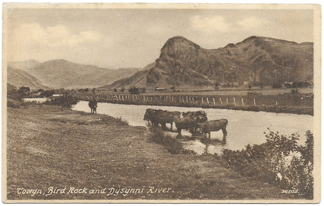 Amongst all the recent postcards, this is one of my favourites, mainly because it is so relentlessly prosaic. Straying out of Aberdovey, but not too far, it’s a peaceful view of cattle in the Dysynni valley with Bird Rock unmistakeable in the background, seen from the west near the coast. Numbered 36502, and dating to 1895 (courtesy of the Francis Frith Collection website for the date) it is characteristic of Francis Frith photographs, offering a slightly unusual take on the usual subject matter. Unlike other contemporary views of scenery which focus on the romantic this shot is particularly evocotive of the the landscape as I have seen it so often, with Bird Rock looking rather intimidating, and the lugubrious cattle waiting patiently for whatever weather is about to emerge from the clouds. Cattle stand in water to cool themselves down on hot days (in some states in America where summer temperatures are usually high, cooling ponds are often provided) so although the sky looks rather overcast, it was probably a hot, sunny day. There is a real sense of timelessness about this photograph.
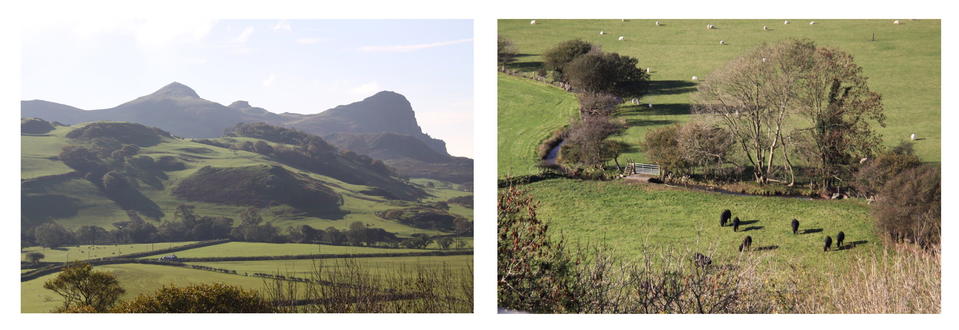 The card was completely unused. I like the “Post Card” font, which has panache. I instantly liked the little saying at the top of the reverse side, below, “T.N.T. – Today, Not Tomorrow!” At first it amused me because it could have been written for me, as procrastionation is probably my worst sin, and I could often do with a bit of explosive to move me in the right direction :-). But when I looked into it, it turns out to be a wartime slogan introduced by British Minister of Production, Captain Oliver Lyttleton, during September 1942, the thrust of which was that there was a new urgency to the production of war supplies. It gives one pause for thought. What is interesting here is that, as above, the photograph is listed in the Francis Frith archive as dating to 1895, but it is clear that the early photograph was re-used later for post-1902 postcard production (see below) and in at least one of its more modern iterations carried a 1942 slogan.
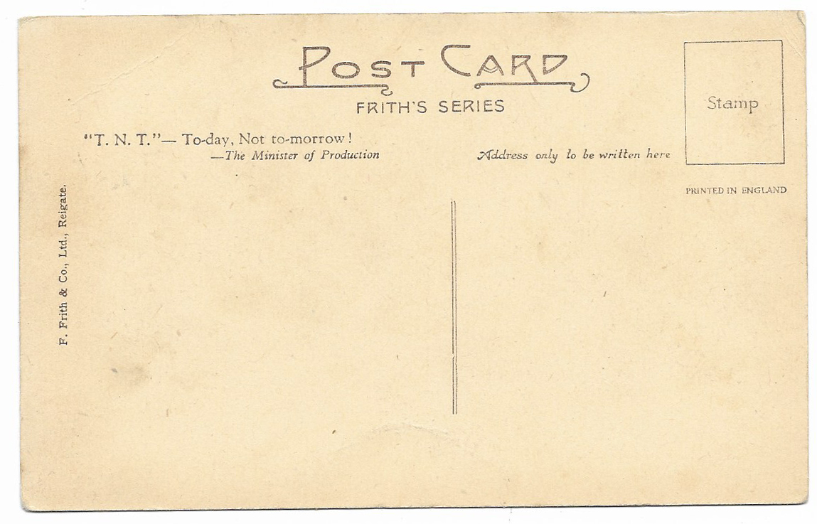 Francis Frith is probably the best name, amongst non-specialists of early postcard production. There is a lot about Frith and his photography business on the Francis Frith Collection website, which is a going concern and preserves an archive of his work. It is a really fascinating story. Frith was born into a Quaker family in 1822 in Derbyshire. He built up a thriving grocery business in Liverpool, which he sold in the 1850s, making him financially independent, in today’s terms a multi-millionaire. A founder member of the Liverpool Photographic Society, only 14 years after the invention of photography, be began to pursue his hobby on a full-time basis, travelling to the Middle East for fourteen years between 1856 and 1860. I was very familiar with his Egyptian photographs, having a particular interest in this field, but the Francis Frith Collection website gives a real insight into the scope of Frith’s intersets and abilities. Marketed by Negretti and Zambra of London, he became rich on the sale of his images as prints and steroscopic views. After he married and settled down in England, he opened his company F. Frith and Co to “create accurate and unromantic photographs of as many cities, towns and villages of the British Isles as possible and sell copies of the photographs to the public, who were travelling in ever greater numbers and looking for souvenirs of their travels.” He eventually retired and left the company to his sons, dying in 1898. His sons built on their father’s legacy, and when in 1902 the Post Office agreed the design for the postcard, with a picture on one side and a divided plain side on the other for message and addresss, the Frith brothers jumped on the bandwagon and became one of the market leaders in postcard production and distribution in the first half of the 20th Century, using the extensive archive of existing photographs.


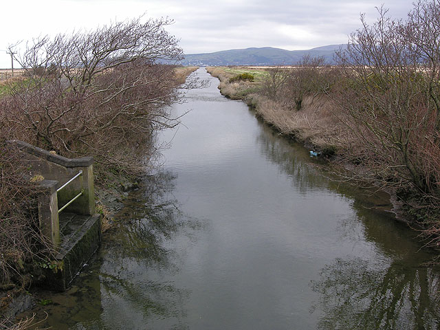
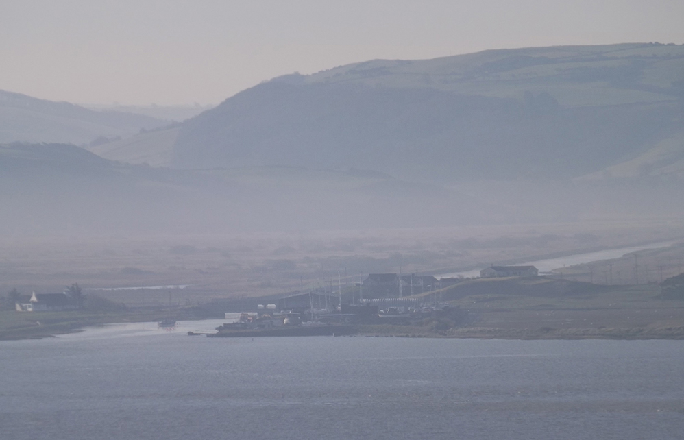
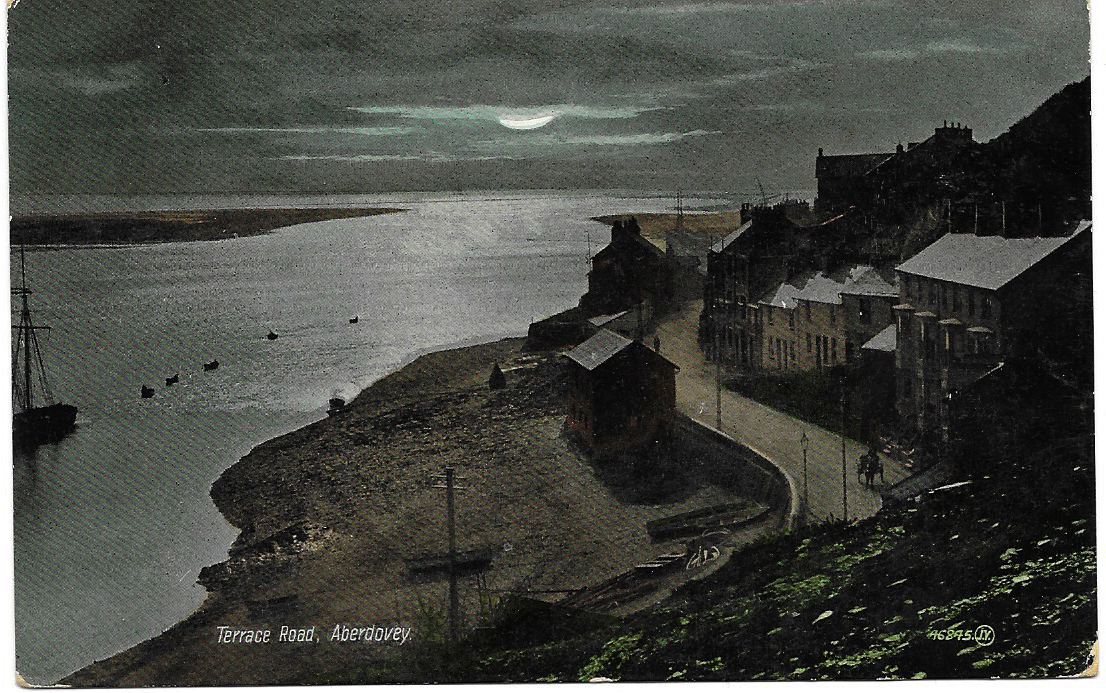

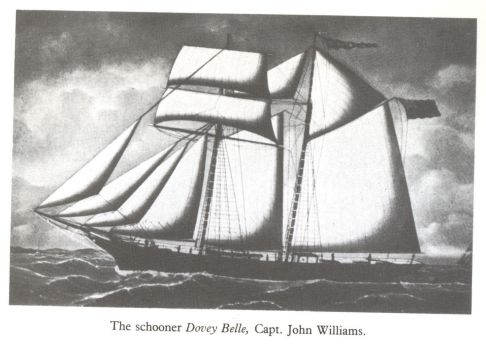
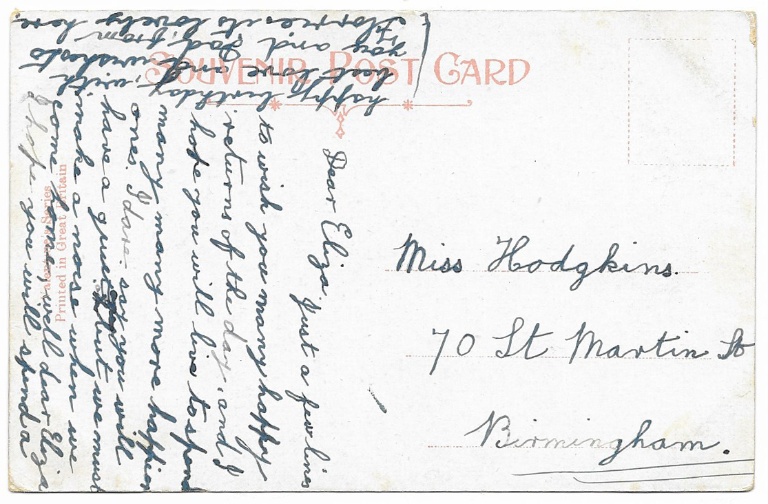

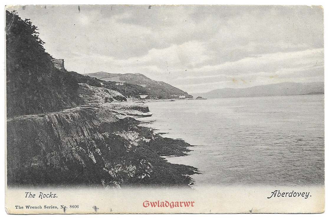
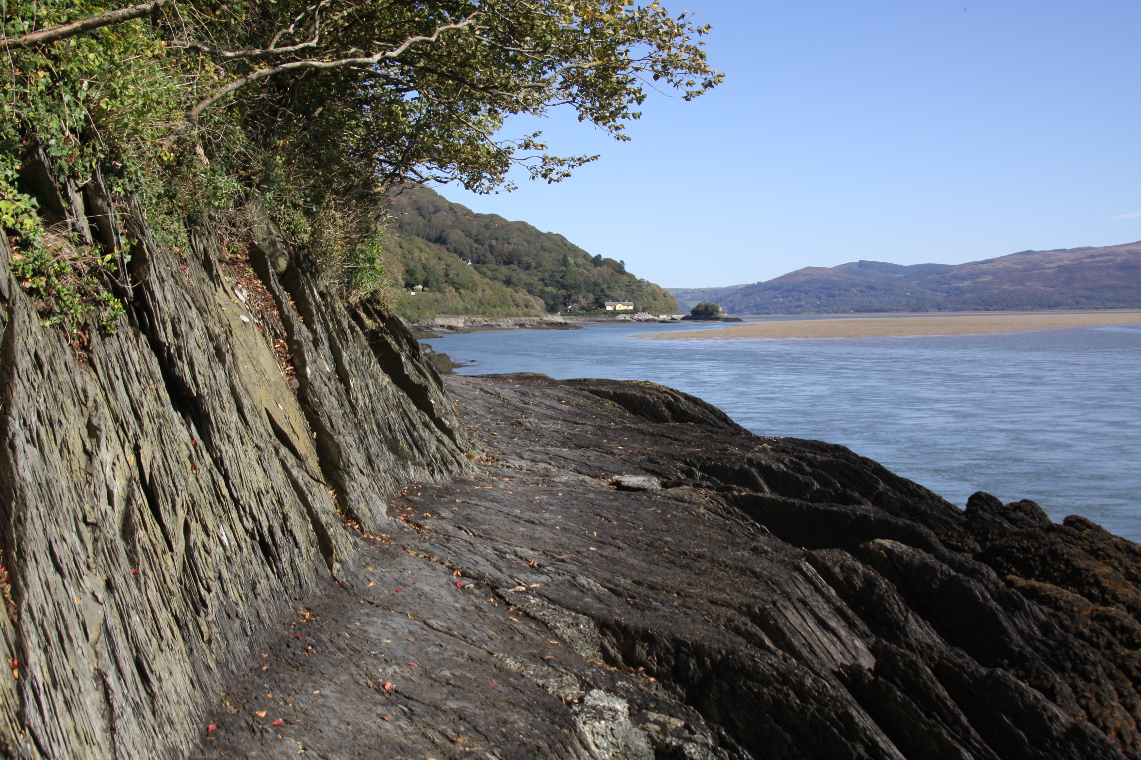
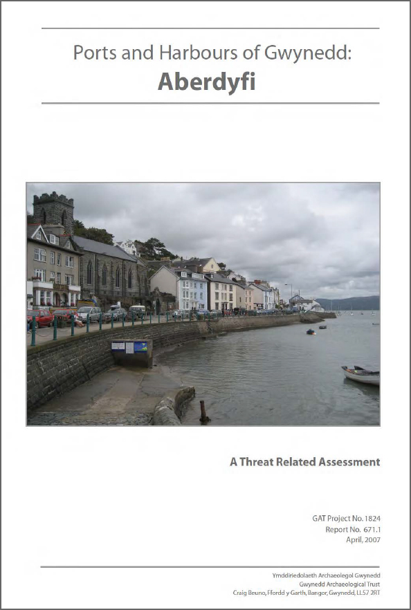
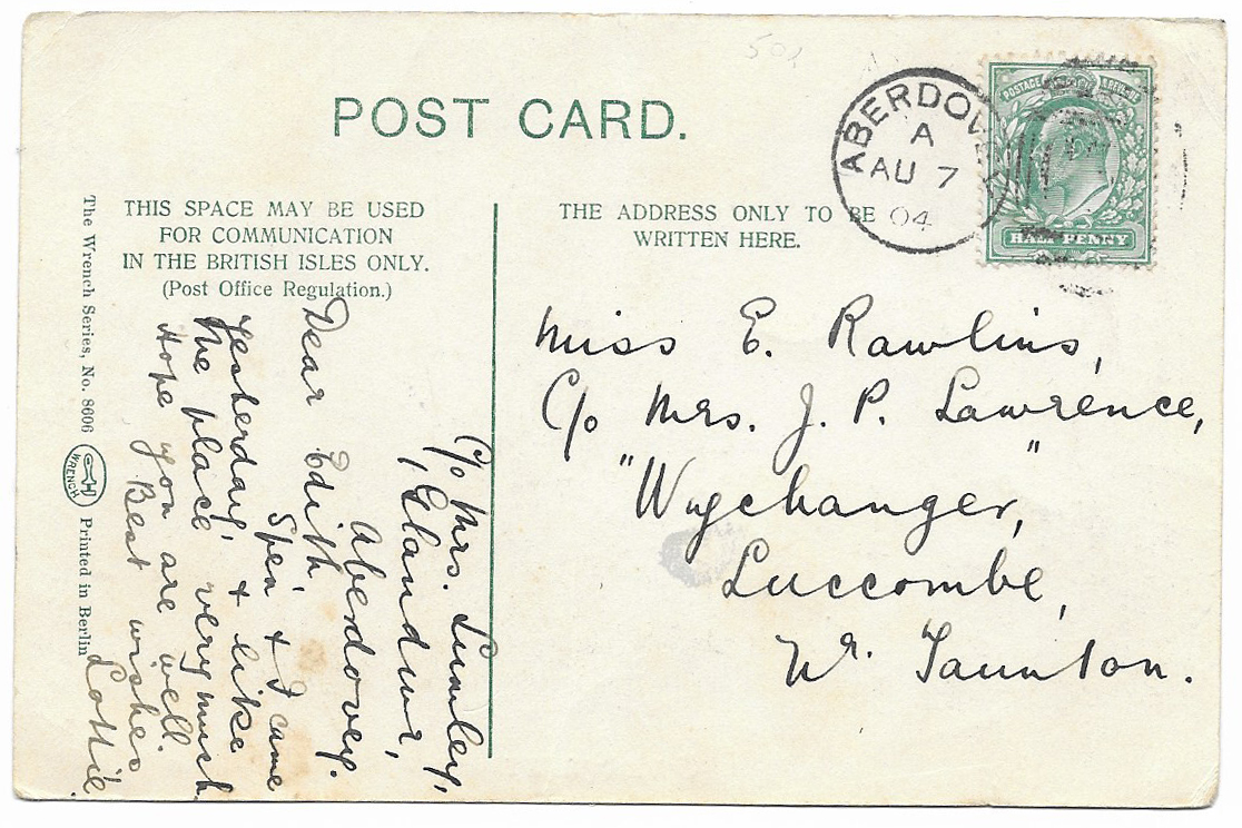

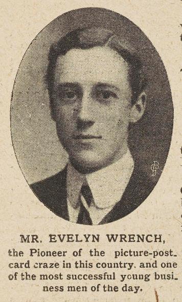
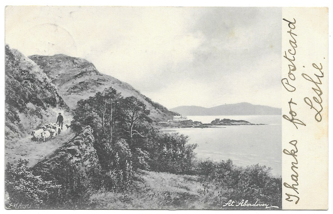
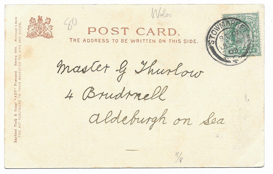
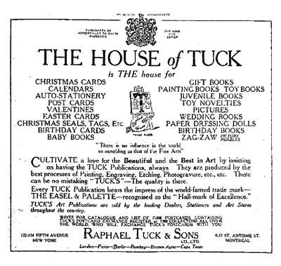
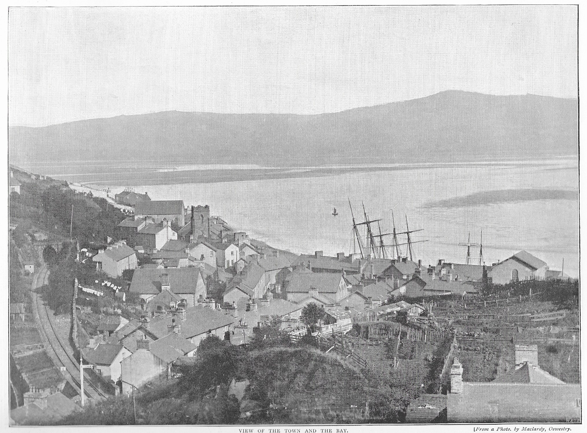
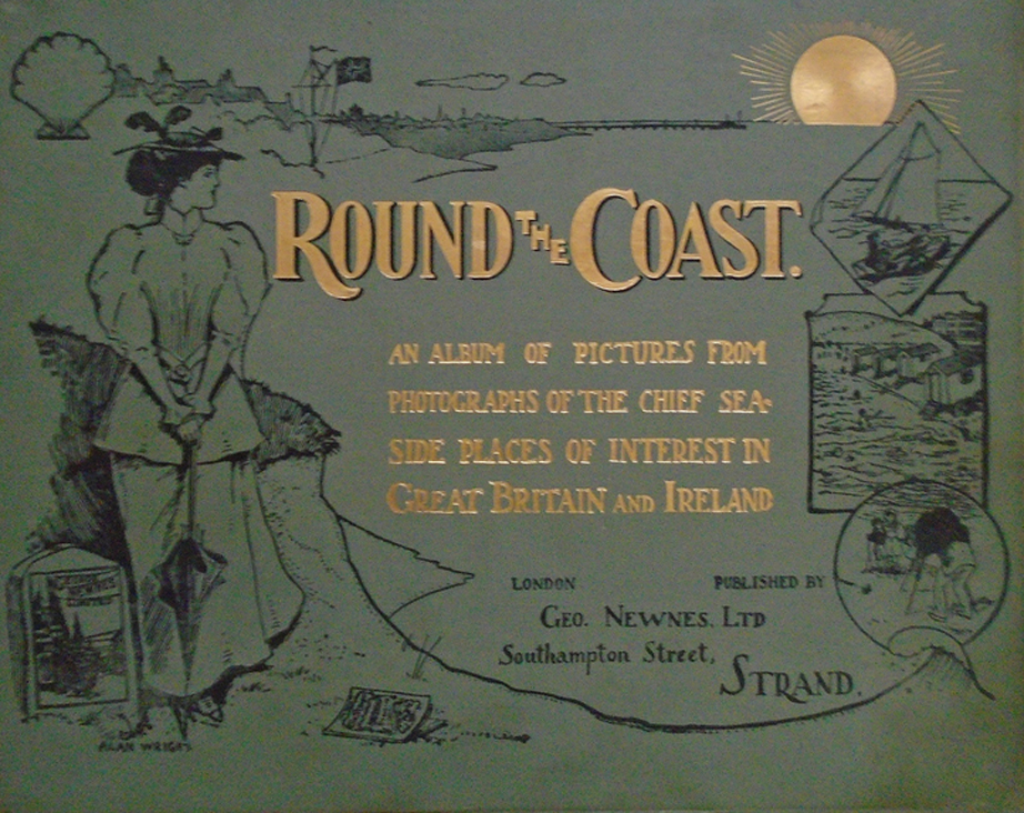
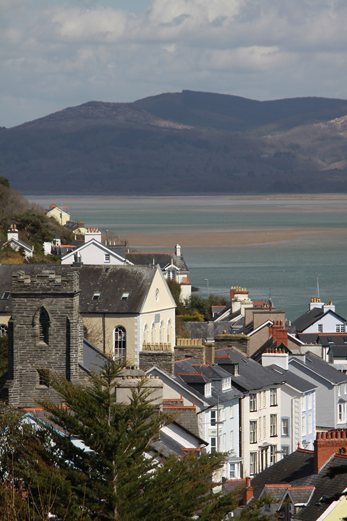
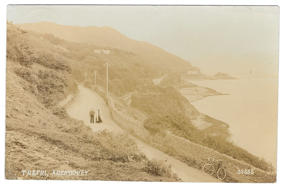
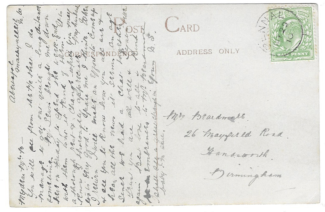
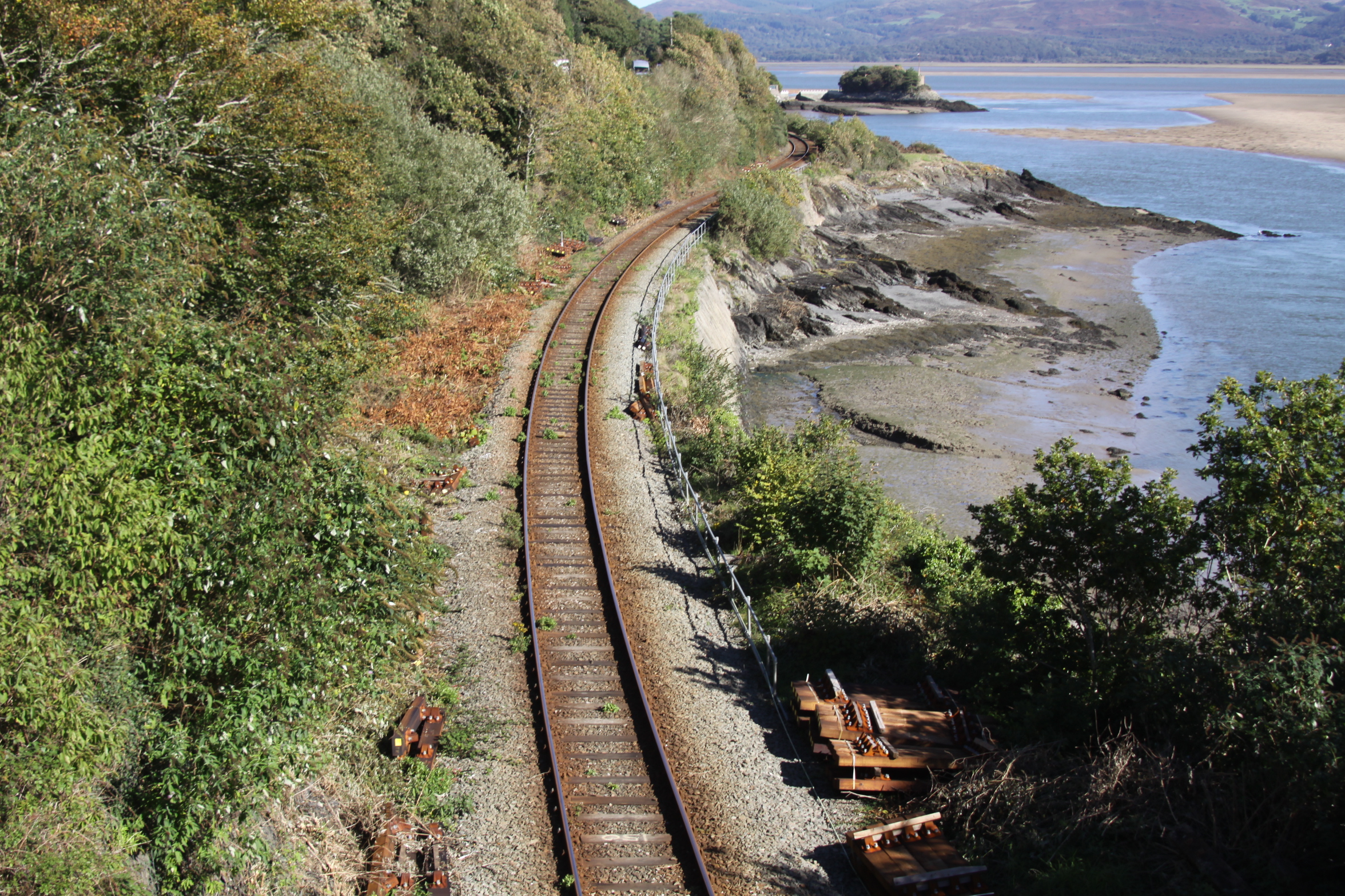


