What a lift to the spirits when the sun comes out! A few snapshots in celebration of a lovely walk on the beach, wrapped up with a really colourful winter sunset.


What a lift to the spirits when the sun comes out! A few snapshots in celebration of a lovely walk on the beach, wrapped up with a really colourful winter sunset.


 It was such a lovely day again that I decided to walk the short stretch along the road that runs along the side of the railway from Tywyn to the new Tonfanau Bridge over the river Dysynni. It forms part of the Welsh Coast Path, which follows long sections of the 882 mile Welsh coastline, with some unavoidable detours inland. Until recently one of these detours was where the Welsh Coastal Path met the river Dysynni at the point at which it opens into the sea. Here it was necessary to divert inland along the Dysynni as far as Bryncrug, returning on the other side of the river to rejoin the coast, an admittedly very attractive detour of some eight miles. In January 2013 this all changed when a new 50m bridge was installed to link the two parts of the Coast Path.
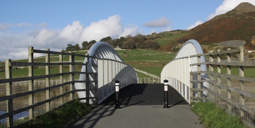
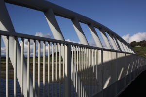 The bridge is of an unusual design, formed of twin crescent-shaped sides of white tubular steel. It is a type known as a Vierendeel bridge, named for its inventor, the Belgian civil engineer Arthur Vierendeel (1852-1940), defined by vertical trusses, rather than the usual diagonal ones. This creates rectangular rather than triangular spaces between the trusses. Most Vierendeel bridges are in Belgium. The bridge cost £850,000 and was funded by the Welsh European Funding Office, Traac, the Countryside Council for Wales and Gwynedd Council. It was installed on the 16th January 2013 by Jones Brothers of Ruthin. It is the largest span for a Vierendeel truss footbridge in the UK. It takes pedestrians, cyclists and horse riders. The Tonfanau Bridge takes its name from the nearby village of Tonfanau, which has an interesting history in its own right and will be discussed at a later date.

Section of the Ordnance Survey Explorer Map (OL23 Cadair Idris and Llyn Tegid) showing the Wales Coast Path, and the start and end point for the short walk between Tywyn and the Tonfanau footbridge over the Dynsynni. Click to enlarge.
The Wales Coast Path (Llwybr Arfordir Cymru – www.walescoastpath.gov.uk) opened in May 2012 and extends between Chester in the north to Chepstow in the south, following the line of the coast wherever possible. The route between Aberdovey and Tywyn goes along beach for four miles, but becomes more complicated when it reaches Tywyn. The map to the left shows the Welsh Coast Path as a line of green dotted diamond shapes. For those who want to walk this short section, I have marked my starting point in the car park on the sea front in Tywyn and the location of the bridge itself.
 In Tywyn you can either walk along the sea front on the promenade or on the walkway that runs the length of the promenade at beach level. The path then goes on to the extended promenade lying between residential housing and the sea. This gives you excellent views of the sea, but blocks views of the hills. Part way along is a turn off between the last of the houses and a mobile-home park. This is a small lane that crosses the railway. From there you either walk along the small road that leads to the footbridge or through the fields. Here, there’s nothing but the raised track of the railway to be seen to the west, although the sea can be clearly heard, but the views to the east are absolutely terrific.
We have been incredibly lucky with the weather recently. It has generally been cold, and there have been frosts in the village, but the sunshine so late in the year has been a splendid treat. There were lots of dog walkers out today, everyone making the most of the weather whilst it lasts.


Ordnance Survey map showing Abergynolwyn, shaded red at bottom right and Castell y Bere in the red square (OS Explorer OL23 Cadair Idris and Llyn Tegid)
Castell-y-Bere is at Grid Reference SH6676908547, overlooking the Dysynni valley near the village of Llanfihangel-y-Pennant. It is maintained by Cadw (Cadw number ME023 ). It is a splendid place to visit. Its remains are substantial, accessed via a short and easy walk, offering spectacularly scenic views over the Dysynni valley that it protected, and is far enough off the beaten track to be wonderfully peaceful. There are various routes to Castell-y-Bere, but if you are not fond of single track roads, the easiest, and almost certainly the quickest, is to go along the B4405 from Bryncrug to Abergynolwyn, turn left in the middle of the village and follow the brown signs to Castell-y-Bere for about 15 minutes. For those that don’t know the roads, they are very good quality with plenty of passing places, and the hedges are kept cut right back, but you do have to resign yourself to the fact that you are almost certainly have to do some backing to passing places before you get to your destination, particularly during the summer when the castle has a lot of visitors. It is very well worth it, however.
 There’s a parking area, and an information sign before you pass through a kissing gate and head along the path. The walk takes you through trees. The stone-cut path is well defined but quite uneven. Although it qualifies as an easy walk and there are no particularly steep bits, there are some fairly sharp drops to the side of the path, so you do have to be sure of your footing. This is even more the case with the castle itself. There are a number of flights of stairs within the castle, some of which terminate at the edge of a steep drop with no barriers. If you walk around using a bit of common sense (particularly if you have children in tow) it is perfect, and so much better than the usual ugly tubular metal barriers that disfigure most heritage sites today.

Castell y Bere aerial photograph with my annotations showing key components of the castle (Source of photograph: Coflein website)
Approaching its original entrance, the castle offers a gloomy and imposing welcome to the building that requires a climb up wooden steps, emulating the original sense of entering into an intimidating stony eyrie,dominated by walls and gate towers, with pits beneath the wooden drawbridges so that when the two drawbridges were raised and each portcullis was dropped there were formidable barriers to entry. The castle itself provides uninterrupted views over the entire landscape surrounding it, which was strategically invaluable in the 13th century when it was built. I was expecting a far more dilapidated structure, but what survives is sufficient to make the reconstruction shown on one of the signs traceable on the ground with very little effort, although it helps to have the aerial photograph to refer to. I have added labels to my photograph of the reconstruction and the Coflein aerial photograph of the castle as it is today, so that my photographs can be related to the original layout of the castle.
The castle was built in 1221 by Llywelyn ab Iorwerth (also known as Llywelyn Fawr, or the Great, c.1173-1240). Llywelyn, prince of Gwynedd, was a remarkable character, a landmark personality in Welsh history whose reign is characterized by military action to extend his power and attempts at diplomacy to retain it. It was one of several that he built, including the important castles at Dolwyddelan in southwest Conwy and Dolbadarn at the foot of Snowdon’s Llanberis Pass.

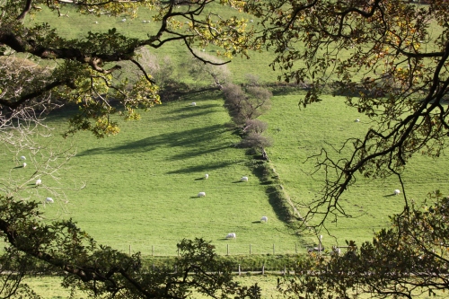
Cattle grazing at the foot of Castell-y-Bere in the Dysynni valley.
The land that Llywelyn chose for his castle was owned by Llywelyn’s illegitimate eldest son Gruffud ab Llywelyn and was taken from him by Llywelyn for the construction of the castle. The glacial Dysynni valley is wide and flat-based, providing unusually wide tracts of fertile pasture. Cattle was one of the principal sources of wealth for the Welsh princes in Gwynedd in the 13th Century, and by controlling the pastures surrounding Castell-y-Bere, Llywelyn was able to protect his herds and provide year-round pasture. Cattle are still herded in the valley, and there were plenty of Welsh black cattle in the fields below the castle when I visited.

The river Dysynni at the foot of Castell-y-Bere
The castle had political as well as economic value. From Llywelyn’s point of view, establishing a realm over the entire area of Merionnydd was part of a much more ambitious plan to extend his control over substantial of Wales that were not yet dominated by invaders from England. Castle building was a relatively new tradition for the Welsh who established undefended courts called llysoedd, which would not have stood up to much in the way of determined attack. At Dolwyddelan Castle, for example, the remains of the earlier llys survive. The Norman advances into Wales from the 11th Century put a different complexion on Welsh strategic thinking. The Norman lords who established their territory in the southeast of Wales, along what is now known as the Welsh Marches, demonstrated how vulnerable the Welsh were to potential hostilities from the east. Timber and earthwork motte and bailey castles were the first defensive structures, but stone castles soon followed.

A photograph of the Cadw sign showing a reconstruction of Castell-y-Bere by Chris Smith. I have added annotations to identify key features of the castle.

View from the middle tower towards the north tower
Llywelyn’s castle was built on a rock outcrop and incorporates much of the bedrock into its construction. As clearly shown in the aerial photograph from the Coflein website above, it was a contour fort, following the line of the rock. The castle’s current substantial form reflects various additions to Llywelyn’s original structure. Its original walls were not as substantial as Edward I’s later additions, and the surviving walls of the original structure demonstrate that this was a much less durable structure than those built by the English. English castles consisted mainly of straight walls connected by either square or round towers. In Wales contour forts were common, and apisidal D-shaped towers were characteristic. Castell-y-Bere has two D-shaped towers, one at each end of the castle, together with a round tower the middle rectangular tower. K. Steele of the RCAHMW describes how the southernmost of these D-shaped towers differs from typical design “being isolated from the main castle structure, overlooked by the rectangular keep, and accessible from the ground floor, thus rendering it defensively weak.” The castle was constructed of the ubiquitous local stone. When the castle was excavated in 1851 some high quality carved stonework was discovered, suggesting that Castell-y-Bere was one of the elaborately decorated of Llywelyn ab Iowerth’s castles.
The following section looks at the history of Gwynedd up until Castell-y-Bere was abandoned in 1295, for which the following family tree might be of assistance:

Llywelyn ab Iowerth family tree for the period during which Castell-y-Bere was occupied

Llywelyn the Great on his deathbed, with his sons Gruffydd and Dafydd in attendance. By Matthew Paris, in or before 1259. Source: Wikipedia
Castell-y-Bere remained in Llywelyn’s possession during his lifetime. Between 1218 and 1240, when Llywelyn ab Iowerth died, peaceful relations were maintained between Llywelyn and Henry III, but the situation deteriorated after his death. Llywelyn ab Iowerth died in April 1240 of natural causes, leaving two sons, his illegitimate eldest son Gruffud and his legitimate younger son Dafydd by his wife Joan. Llywelyn had disinherited Gruffud in 1220 to ensure that Dafydd ab Llywelyn would succeed him, an arrangement that was rubber-stamped by the Pope, thanks to the intercedence of Henry III. When Dafydd ab Llywelyn inherited his father’s seat, Henry re-organized. Dafydd’s disinherited half brother Gruffud was handed over to Henry for imprisonment in the Tower of London to prevent any attempt to oust Dafydd and destabilize Gwynedd, and Dafydd’s own rights were undermined. Gruffud died at the Tower in an escape attempt in 1244. Dafydd died of natural causes without an heir in 1246.

Stairs leading up to the rectangular middle tower
The power vacuum allowed Henry III to enter Gwynedd and establish Crown control over the most powerful of the strongholds in Wales, now under the leadership of Owain and Llywelyn ab Gruffudd, two of Gruffud’s sons. A third brother, Dafydd, was also a beneficiary. They inherited a Gwynedd under siege, and peace was purchased with the provision of knights and foot soldiers. Wales remained subjugated until the three brothers came into conflict with each other, Llywelyn ab Gruffudd emerging triumphant and proceeding to take over large tracts of Wales. From 1258 until 1262, whilst Henry was busy with a rebellion of the barons under Simon de Montfort, he consolidated his new territory, securing its borders. However, in 1262 he was on the march again, claiming new territories in the far south. He formed an allegiance with Simon de Montfort in 1265, formalized in the Treaty of Pipton, and although Simon de Montfort was defeated and killed in battle only weeks later, Henry III chose to honour the Pipton agreement in the Treaty of Montgomeryshire in 1267. The principality of Wales was formed, with Llywelyn ab Gruffudd officially recognized as Prince of Wales, with the right to homage of all the Welsh lords, for which privilege he paid 25,000 marks and became a vasal of the king.

Entrance into the building providing access to the north tower.
Llywelyn ab Gruffudd had made a lot of enemies, particularly in the Marches. In 1271 he attacked Caerphilly castle and extended his realm even further. Davies says that his authority “extended from Anglesey to Machen, from the outskirts of Chester to the outskirts of Kidwelly. He was lord of about three quarters of the surface area of Wales and of as somewhat lower proportion of its inhabitants. He had perhaps two hundred thousand subjects.” However, the powerful Marcher houses of Clare, Bohun and Mortimer came into direct conflict with Llywelyn, and in 1274 both his brother Dafydd and his chief vassal abandoned him, going to England. Henry III had died in 1272, but his heir Edward I was away on the Crusade and did not return to claim the crown until August 1274.

One of the rectangular structures in the courtyard
The relationship between Llywelyn and Edward I was strained from the very beginning, caused partly by Llywelyn’s marriage to Elinor, the daughter of Simon de Montfort and by Llywelyn’s refusal to travel to the English court to pay homage to the king. Edward retaliated by abducting Elinor and in 1276 Llywelyn was labelled a rebel. Permission was given to the Marcher Lords to reclaim territories that they had lost and the king himself prepared for war against the prince and took an army of 800 knights and 15,000 foot soldiers into Gwynedd. Llywelyn, cut off from food supplies in Anglesey, submitted in November 1277. The Treaty of Aberconwy in 1277 swept away Llywelyn principality in all but name. Much of eastern Wales was lost to Norman control and castles were established to maintain control in key areas of Gwynedd, giving Edward nearly complete control by 1280.
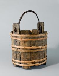
Oak bucket bound with hazel, with hazel pegs, found in the well. Source: National Museum of Wales. 53.123/4.
More uprisings followed, in particular the war of 1282-3 that spread after an attack by Llywelyn’s brother Dafydd ab Gruffudd on Hawarden and Rhuddlan Castles. Llywelyn ab Gruffud had little choice but to participate but all these attempts were ultimately futile. Llywelyn ab Gruffud was killed in battle on 11th December in 1282 and Dafydd assumed the title Prince of Wales but by early 1283, Edward I’s vast English army had the Welsh heartland hemmed in. Dafydd based himself at Dolwyddelan Castle in southwest Conwy whilst the English took Bangor, Caer-yn-Arfon and Harlech, building vast castles as they went. Castell-y-Bere was the last of the Welsh strongholds to withstand Edward’s armies, falling in April 1283. Dafydd was captured in June 1283. He was tortured and put to a grizzly death in Shrewsbury in October 1283, whilst Edward’s programme of castle building continued uninterrupted.

The rubble interior of the walls, in a section probably reinforced by Edward I.
Castell y Bere survived the 1283 battle and under Edward I a number of improvements were made. It received additional fortifications, in particular thick walls linking the south and middle towers. The large rectangular keep overlies a rock-cut ditch suggesting that it had the adjoining D-shaped tower are additions to the original castle may be from this time. Edward wanted to establish an English borough and a charter was granted, extending from Abermaw to the Dyfi, but the site never prospered. In 1284 the Statute of Wales, or the Statute of Rhuddlan, was initiated. The three counties of Anglesey, Caernarfon and Merioneth were created and placed under the management of English sheriffs, effectively splitting Gwynedd into manageable administrative chunks and ending the dreams of Llywelyn ab Iorwerth. A last ditch Welsh uprising during 1294-5 ended Castell-y-Bere. Madog ab Llywelyn attempted to take the castle from the English. He failed, but the castle was very badly damaged in the process and was abandoned. The 1850 excavations found extensive charcoal, suggesting that it may have been burned.
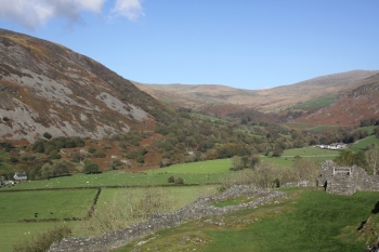
View along the castle towards the pastures in the Dysynni valley
The 1850 clearance of the site produced some other interesting discoveries. One of the excavators W.W.E Wynne describes opening the excavations in an article in Archaeologia Cambrensis “in the year 1850, we commenced our excavations, not with the expectation of discovering any object of superior interest, but for the purpose of tracing as accurately as possible the circuit of the walls and making a plan of the building.” It was during these excavations that the ornamental stonework and other masonry fragments were found. Other items discovered were pieces of chain-mail, corroded arrowheads, part of a crossbow, several knives, one retaining a wooden handle, part of a bone comb and large amounts of pottery, mainly glazed in green or olive. Animal bones bearing signs of butchery included roe deer and boar.

Plate from Wynne’s 1861 report of the 1850 excavations.
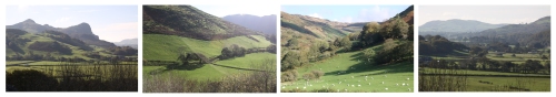
Views from Castell-y-Bere over the pastures that are used today for grazing cattle and sheep
References:

Stonework from Castell-y-Bere, held at Criccieth Castle Museum. Source: Hchc2009 under CC-BY-SA-3.0 licence
Avent, R. 2010. Dolwyddelan Castle, Dolbadarn Castle, Castell y Bere. Cadw
Davies, J. 2007. A History of Wales. Penguin
Glamorgan-Gwent Archaeological Trust http://www.gatehouse-gazetteer.info/Welshsites/510.html
Jenkins, G.H. 2007. A Concise History of Wales. Cambridge University Press
Steele, K. 2008. Castell-y-Bere. RCAHMW, 4 November 2008 http://www.coflein.gov.uk/en/site/93719/details/castell-y-bere.
Wynne, W.W.E., 1861. Castell y Bere, Merionethshire. Archaeologia Cambrensis Vol. 16 p. 105-10 https://archive.org/stream/archaeologiacam07moorgoog#page/n121/mode/1up
 My visit to Castell-y-Bere on Monday, via a very short detour to Tal-y-Llyn, was a perfect cocktail of lovely sun-kissed scenery, well maintained heritage and a clump of fascinating education all in one visit. What’s not to love? If you wake up to a glorious autumnal day like this one, why not consider sorting out all your bits and pieces in the morning and then hop into the car and go to Castell-y-Bere for an hour or two. It’s the perfect excuse for a tiny holiday-like experience.
I have written up the castle itself and its history on another post, here, but here are some photographs of the surrounding scenery. With the sun reflecting off fast-moving streams, filtering through the reds, oranges and yellows of autumn leaves and lighting up the stunningly bright greens of the grass, and the rust-coloured foliage on the hillsides it was just about the most idyllic day I have had at Aberdovey so far. I spent most of last week in London. It was super to visit my former home, but the contrast was unbelievable. The feeling today of being let loose on life was exceptional.


Desert boots turn out to be surprisingly well suited to Welsh footpaths. My other hiking boots have not yet emerged from the packing boxes, but these did fine.
 Sunshine, sand, sea and almost no-one on the beach but me. Idyllic. When I woke up this morning it was cold and grey, but by noon the day had clearly decided to fall in line with the weather forecast and blossomed into a glorious autumn afternoon. I had stuff I needed to do but I was done by 2pm and drove to the lay-by on the road to Tywyn, opposite the line of houses on the other side of the Trefeddian Hotel. A path crosses the golf course, wends its way through the dunes and drops you by the Second World War pillbox. From there Tywyn is clearly visible in the distance. The tide was out, just on the turn, so it took a couple of minutes to reach the water’s edge, although the roar from the waves had been clearly audible from the road.
 The beach was spectacular, the damp sand reflecting blue sky and white clouds, with deep dips holding pools of water like liquid silver and white-topped blue waves thundering as crests broke, chaotic shapes forming and reforming. The main strandline was up by the dunes, clumps of dark weed, but there were long strands of weed shimmering in the sunshine, some floating in pools some strewn along the sand. I took a few photos and a couple of videos as I walked towards Tywyn, got wet feet, and generally had a great time. It really was a spectacular afternoon. A lady on the checkout at the Co-op in Tywyn, who also moved here from London, told me that the novelty lasted six months with her, but I really don’t see it ever wearing off for me. Mind, I haven’t survived an Aberdovey winter yet.

Crossing the sand dunes. Close to the beach they are stablized by marram grass.

The first and last photos are burnet roses, small and delicate, that are usually found in sand dunes. The pink petals belong to a blackberry bramble and the blue berries are blackthorn, also common in sand dunes.

Lovely shapes and light on the wet sand

Ecofacts. The shells are a limpit with a beautiful yellow shell, an elegant variegated scallop, a saddle oyster and a purple-black common muscle. An articulated crab claw has become detached from its owner. This was the first cuttlefish bone that I have found on the Aberdovey beach, beautifully laminated. Within the calcium-rich shell there are chambers that that fill with gas or water allowing the cuttlefish to rise or sink.

Here are two of the videos. I am still trying to get the hang of this whole video thing. The autofocus on the little camera that I use for video was having trouble today, unsurprisingly, and it was having trouble with the shifting light too. And of course, it was absolutely not all the camera’s fault that these are anything but perfect. This was my first time trying to video the sea, and the learning curve shows rather acutely! Huge fun though, and I’ll get there eventually.

The lay-by to park for this stroll on the beach is at The Crossing, just where the A493 goes around a slow but definitive bend. It is opposite a very fine terrace of tall houses. The footpath is a track on the left of the lay-by and takes you over two stiles across the railway. You then cross the golf course to walk along the path through the dunes and down on to the beach by the Second World War pillbox, marked on the above map with a red rectangle.

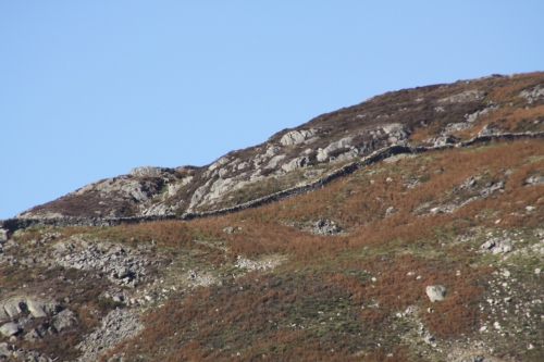
 If you are looking for a short walk with some lovely views over the river estuary and the hills beyond, this is a nice one. If you want to go all the way to Picnic Island, a walk of just 30 minutes or so, you will need to be prepared to pick your way along some jagged rocks, but if you only want to go as far as the beach beneath the footbridge over the railway line, it’s a simple walk along well worn paths. You can also turn it into a much longer 6 mile walk by crossing the footbridge and going up the hill and circling back into Aberdovey. I’ve added a PDF at the end of this post. Patches can be a bit muddy after rainfall and on the rock this can be slippery, so suitable footwear is recommended. Before you set out, check the tides. You will need to avoid high tide, because part of the walk is cut off by water. If you do find yourself returning along the path to meet with an unpassable section you will need to cross the bridge over the railway and return along the road, but this is a busy road with no footpath so is much best avoided.
 The walk is all about beautiful views over the estuaries and to the hills beyond. It starts in the Memorial Park at Penhelig. Either go under the railway bridge or cut off that rather dangerous corner on the road by taking the private road in front of the houses known as Penhelig Terrace. The Memorial Park is on the other side. It is a lovely little park with great views over Aberdovey’s sea front. It contains a memorial and a plaque in English and Welsh to mark the achievements of the 3 Troop 10, a group of German nationals who worked on behalf of the Allies during the Second World War, and who were stationed in Aberdovey for their training (which I have described on an earlier post). There is also a little shelter, slightly unkempt at the time of writing, to the memory of Mr Richard Roberts “in recognition of his munificent gift for improvements at Aberdovey 1930.”
 At the far end of the park let yourself through the gate and onto the Roman road. The so-called Roman road is neither Roman nor, in modern terms, a road. It is a path carved out of the local mudstone, a remarkable feat that even the Romans, accomplished civil engineers, would have found a difficult task without the help of explosives. And why would they have gone to the trouble? The nearest Roman military structure was Cefn Caer at Pennal, 11km to the east along the Dyfi. There is no obvious benefit for a permanent stone-built pathway to Aberdovey, even if there was any sign elsewhere between Aberdovey and Pennal of a long-term Roman presence, which there isn’t. My guess was that it was built in the 1860s, part of the works for the building of the railway, but again that fails to address the question of the purpose of such a track, given that there was a perfectly good coast road at that time. In his description of the 6-mile walk, below, the author David Roberts, an Aberdovey resident, states that the track was built in 1808 for horse and carriage, but he doesn’t say where these were headed and why such a road would be required. Even Hugh M. Lewis, who was born in 1910, and grew up and lived in Aberdovey was unable to shed any more light on the subject.
 Whenever it was built and whatever it was used for, it is invaluable today as a ready-made footpath for walkers. The path has two small bridges that cross little natural outlets for fresh water that pours down the hill into the estuary. In these places the fresh water-loving gut weed grows, a livid, bright green that contrasts dramatically with the black stone and the brown seaweeds. The estuary is incredibly peaceful on a sunny day as the tide retreats, the waters flat and sparkling, making a pleasant sound lapping gently at the rocks as they travel at a considerable pace to the west. The hills beyond, in Cerdigion, fresh and green, are the perfect backdrop.
 The ubiquitous mudstone, into which the path is carved, slopes gently down into the waters, and is covered with some of the seaweeds that I described on my strandline walk, fascinatingly three types forming three bands as they approach the water, with those most equipped to survive out of the water for longest at the top, and the least drought tolerant at the bottom. Sea oak is at the top, bladder wrack in the middle and egg wrack at the base. some of it remaining submerged even at low tide. Unlike my strandline walk, where all the seaweeds had been detached from their rock bases, it was possible to inspect the seaweeds in situ, so I could see the holdfast with which they attach themselves to rocks, a surprisingly tiny little mass of highly tenacious material.
On the rock face above the level of the path, two plants in particular make the best of the most implausible nooks and crannies to grow: red valerian and sea thrift. Both are drought resistant, saline tolerant, prefer sandy and low-fertility soils and need full sun, so are frequently found in south-facing coastal areas. When the sea thrift goes over, which most of them have by late September, the fallen petals leave attractive skeletal globes. Watch out for sea thrift and red valerian in cracks in vertical planes of the rock to the left as you walk towards Picnic Island. Where the rock splits it reveals trapped minerals that are often beautifully coloured providing a perfect canvas for the flowers.

 At all levels above the waterline are a variety of lichens dominated by yellow scales (shown to the right), which is prolific, followed by black shields and map lichen. Lichens are not single organisms but are symbiotic, depending for their survival on “photobionts” (algae and/or cyanobacteria), which provide them with the carbon that they need. The photobionts use the process of photosynthesis to manufacture their own food source, whereas the fungal component of the lichens need an external food source. This ecological strategy has obvious benefits for the fungus, which is essentially parasitic on the photobionts, but it is thought that the photobionts might benefit too, due to the provision by the fungus of a stable environment in which they can develop. There’s a lot more information on the British Lichen Society website.
The Roman road runs out and is replaced by a well maintained footpath that runs parallel to the railway line, taking a route several feet above the estuary, again with wonderful views across the estuary. At low tide the sands in the middle of the estuary are revealed, a shifting chiaroscuro of colours and deep shadows framed by the speeding waters of the retreating tide. There is rich vegetation along the footpath – blackberry and rose brambles, ferns, berberis, purple thistles, red valerian, buddleia, holly, wild oregano and much more. In autumn there are few flowers, mainly the last of the red valerian, but there is a profusion of red and orange berries.

 A fork in the path offers a choice. The left fork leads up to Picnic Island and the footbridge over the railway into a lay-by and, 100m down the road, the continuation of the walk for those who want to pursue the 6 mile option. Picnic Island is not an island, just a small promontory cut off from the hillside by the railway, but it has wooden seating and is a pleasant green area with excellent views south over the estuary. It’s original name is Bryn Lestair (obstruction hill).
The right fork leads down steps to a small pebble beach, and the continuation of the Roman road for a short span, before it runs out again. The beach was the site of a shipbuilding business, some of its walls still surviving, but the site was largely destroyed by the railway. From the beach, facing the sea look left and you will see that the Roman road resumes. Follow this for a short distance and then it’s a matter of picking your way down the rocks to the beach, and along the foot of the retaining wall behind which the railway runs. This is invariably wet, with hillside water pouring from under the wall. There were almost no shells on the beach sections, only very fragmented muscles and barnacles. The barnacles were on loose bits of slate, so they were probably detached from rocks elsewhere and brought in on the tide. This is probably because the waters are brackish, combining freshwater pouring out of the river Dovey and salt water coming in on the tide.
 On the other side of this small beach is another promontory with views over the estuary and east towards the Georgian Trefri Hall with its own island complete with crenellated folly. Before it was painted mustard yellow it was my favourite house in the area – that wonderful location, those stunning views, a private tidal beach and that super folly! In 2016 it came on the market and was featured in an article on the Wales Online website – for sale for a cool 1.7 million pounds. Rather more than I had in my piggy bank on the day.
The walk back into Aberdovey is simply a matter of retracing your footsteps.

If you are interested in the 6-mile walk that takes you up into the hill behind the estuary, here’s a PDF to download: 6 mile circular walk Picnic Island and hill. It is the BBC Weatherman Walking map and guide by local resident David Roberts (eight pages with photographs). I haven’t done it yet, but it looks splendid and it’s on my to-do list.

Glan-Dovey Terrace with Pen-y-Bryn behind and the white 19th Century shelter on top.
Overlooking Aberdovey’s sea front is a little white shelter on a small hillock, a popular destination with tourists and dog walkers known in the 19th Century as Pen-y-Bryn, which translates as Head of the Hill. The original name of the hill may have been Bryn Celwydd, Hill of Lies, which is recorded on a chart of the Dyfi Estuary dating to 1748. A number of guides to Aberdovey place Aberdyfi Castle on that spot. For example, in Aberdyfi: The past Recalled by Hugh M. Lewis has a page describing the castle, “possibly a motte and bailey castle or more probably a castle of wattle and daub which was defended by a stockade,” locating it at Pen-y-Bryn. However, although it is recorded that certain historical events clearly took place at a castle of this name, and it receives particular mention in the late 12th-early 13th Century Brut-y-Tywysogion (Chronicle of the Princes) compiled at Strata Florida abbey, the identification of the castle with the bandstand hill, and even with Aberdovey itself, is very doubtful.
To begin with, Pen-y-Bryn always seemed to me a most improbable as the site of a castle, even a small one, even allowing for substantial alteration of the profile of the hill over time. In a motte and bailey arrangement a fortification sits on a natural or artificial mound with an accompanying settlement in a walled/fenced area at its foot, sometimes surrounded by a moat or ditch. Pictures of ruins and artistic reconstructions based on excavations indicate that the motte might support a fortification that was little more than an elaborate shed, as this reconstruction from the Dorling Kindersley Find Out website suggests. That nothing substantial could have been built on the Pen-y-Bryn site does not rule it out of being Aberdyfi castle, but the events that are described below would indicate that a large structure would have been required to defend an important fortified settlement, particularly one selected for the vital political assembly that established the primacy of a Welsh prince as ruler of most of Wales.

Dorling Kindersley reconstruction of a motte and bailey castle showing the main features. Fortifications could be very small. Source: Dorling Kindersley Find Out website.
The Aberdyfi Castle was twice used as a base for important documented meetings of Welsh rulers, first in the 12th and then in the 13th Century, but the name is also connected with a much less secure event that allegedly took place in the 6th Century. A rather more plausible alternative to Pen-y-Bryn for the castle is the site of Dolmen Las on the south bank of the Dyfi at Glyndyfi in Ceredigion, suggested by a number of authors.
 What is clear is that wherever the castle was located, it was a Welsh one, rather than an English one captured by the Welsh. The Norman invaders were innovators of the use of castles in Wales, but it was not long before Welsh leaders, observing and suffering the effects of this new powerful strategic device, were able to learn from it and build their own versions. Rhys ap Gruffudd the powerful 12th century ruler of Deheubarth was amongst the first to take to castle building, and in his biography of Rhys, Turvey suggests that this castle was one of his.
Aberdyfi is first connected with Maelgwyn Fawr (Maelgwyn the Great, Maglocunus in Latin), descendant of Cunedda, and ruler of Gwynedd. This is mentioned by Davies who says that “according to tradition it was at Aberdyfi that the suzerainty of Maelgwyn Fawr had been recognized seven hundred years earlier.” This apparently endowed Aberdfyi with a certain status as a place associated with the triumph of a Welsh ruler in achieving a status approaching that of a king.

Effigy of Rhys ap Gruffudd from St David’s Cathedral. Source: Wikipedia
According to Turvey, Aberdyfi Castle itself seems to have been founded by Rhys ap Gruffydd (1132-1197) in 1156, the ruler of Deheubarth, the second most important region in Wales, in order to counter the expansionist policies of Owain Gwynedd (or Owain ap Gruffudd, 1100-1170), ruler of the most important region at the time, Gwynedd. Rhys and his brothers had invaded Ceredigion in 1153, having already consolidated their position in Dyfed and Ystrad Tywi, and by the time Henry II came to power, John Davies says that Owain Gwynedd’s realm “extended almost to the walls of Chester,” taking in much of the earldom of Chester and the kingdom of Powys. The northern frontier of Deheubarth and the southern border of Gwynedd met at the river Dovey, making the river strategically significant. Rhys was continually at war with the Norman Marcher lords to the east, and in 1158 Roger de Clare captured the castle in but was ousted by Rhys in the same year.

Llywelyn the Great with his two sons, by the Benedictine monk Matthew of Paris (1200-1259). Source: Wikipedia
In 1216 an important meeting took place at Aberdyfi Castle, 15 years after the death of Rhys. Its purpose was to formalize the position of Llywelyn ab Iorwerth (c.1173-1240), grandson of Owain Gwynedd who became known as Lywelyn Fawr (Llwelyn the Great), to receive the homage of other Welsh rulers and to divide Deheubarth among the descendants of Rhys ap Gruffudd. Llywelyn ab Iorwerth was born in Gwynedd, which throughout the early Middle Ages had shown the most promise for becoming the leading territory in Wales and a unifying force for the various regions that made up Wales. The assembly was intended to reinforce the position of Llywelyn as pre-eminent ruler in Wales. At the Aberdyfi castle gathering minor rulers of the Deheubarth territory confirmed their homage to Llywelyn, and in return Llywelyn divided Deheubarth amongst the descendants of its deceased ruler Rhys ap Gruffudd. Aberdyfi Castle was probably chosen for the meeting partly because of the Maelgwyn Fawr connection, lending historical gravitas and integrity to the event.

The location of Domen Las
So where was Aberdyfi Castle? Even though it has been claimed that there may have been a Welsh fortification on the bandstand site, it is clearly not a suitable venue for the types of assembly described above. Instead, a far more probable venue is Domen Las, which appears to be the remains of a motte at Ysgubor y Coed near Glandyfi (translating as bank of the river Dyfi) on the south side of the river Dyfi in Ceredigion, map reference SN68729687. This fits in with the identification of Rhys as its builder and its location in his Ceredigion territory in Deheubarth. The name Aberdyfi simply means “mouth of the Dyfi” and although Glandyfi is not at the mouth of the estuary, it is located at the point at which the river begins to open out into the estuary and may have been a crossing place. More significantly, Domen Las faced the mound of Tomen Las near Pennal in Gwynedd (SH697002), which may have been a motte established by one of the Gwynedd rulers, and possibly in use at the time that Aberdyfi Castle was built. In addition, from Owain Gwynedd’s point of view, there would have been an obvious strategic link between Gwynedd and Deheubarth. Dividing up Deheubarth from a point within Deheubarth but just over the border from Gwynedd and in sight of it would have been a powerful message to the descendants of Rhys. Finally, although the 6th Century Maelgwn association with Aberdyfi pre-dates Rhys’s castle by five centuries, it may have had something to do with the castle’s name.
Domen, meaning mound, and las meaning green in old Welsh (blue in modern Welsh) describes the site perfectly. It is an overgrown mound on the edge of the river Dyfi. John Wiles describes it as follows on the excellent Coflein (The online catalogue of archaeology, buildings, industrial and maritime heritage in Wales) website:
The medieval castle of Domen Las is represented by a castle mound or motte. This is notable for the way that it is fitted into the natural topography and for the remarkable configuration of its ditch.
The castle faces north-east across the upper Dyfi estuary towards Pennal, the court of the Princes of Gwynedd in Merioneth (see NPRN 302965), and was built in 1156 to counter those Princes’ ambitions in Ceredigion. It may then have been the sole castle in Geneu’r-glyn commote, as Castell Gwallter at Llandre is not heard of after 1153 (see NPRN 92234). Domen Las is probably the castle of Abereinion mentioned in 1169 and 1206.

Domen Las in the bird sanctuary Ynys Hir. The small wooden building is a bird hide. Source: Castles of Wales website. Photograph by John Northall, copyright John Northall
The castle mound is set near the northern tip of an isolated straggling rocky ridge rising from the marshes. It is a circular flat-topped mound roughly 34m in diameter and 5.0m high. It is ditched around except on the south-east, where the ground falls steeply into the marsh. On the west side a rocky ridge serves is co-opted as a counterscarp. On the north side the ditch has the appearance of a regular basin, closed on the east side by a wall of rock pierced by a narrow gap. This could be a pond or cistern, and is surely an original feature.
There are no traces of any further earthworks. The castle mound was probably crowned by a great timber-framed tower and it is likely that a princely hall and associated offices stood nearby. These could have occupied the irregular platform on the northern tip of the spur above the river, although there is a more a more amenable location on the south side of the motte, where a level area is sheltered by the rocky ridge. A little to the south a small bank cuts across the ridge. This was probably a hedge bank and may be comparatively recent.
The identification of Domen Las as Abereinion castle by Wiles and others is interesting and muddies the waters more than somewhat. The River Einion flows into the Dovey very near Domen Las but there is also a River Einion to the south, and in The Welsh Chronicle it is listed as having been built by Malgwn in 1205 and is sometimes identified with the mound at Cil y Graig in Cardigan as Abereinion Castle. It is entirely possible, of course, that both names were applied to the same castle. If that were the case, the Domen Las site is the most plausible location as it is both at the mouth of the river Dovey, where it spreads into the estuary, and at the mouth of the river Einion, where it joins the Dovey.

Location of Tomen Las (click to expand the image). Sources: Main map from Google Maps; Insert from the Coflein website.
Another candidate for Abyerdyfi Castle is Tomen Las near Pennal. This is actually within Gwynedd with clear views over the estuary to Ceredigion and to Domen Las. At the south of Gwynedd, near the borders with Deheubarth, this is yet another plausible site. The Coflein website suggests that it was a former court (llys) of the princes of Pennal and describes the surviving remains as a circular mound 26m in diameter that rises 3.0m from the traces of its ditch with a level summit 15-17m across. There are no traces of further earthworks.
The short answer to the question posed in the title of this post is that there is no definitive location for Aberdyfi Castle. I have searched for but failed to find any records that the Pen-y-Bryn or Domen Las sites have been excavated, but it would certainly be interesting if future research into the question were to extend beyond analysis of the late Medieaval texts and into the field. If I had to put money on it, I would go for the Domen Las site, mainly because of the political significance of the location just over the border of Gwynedd in Ceredigion, a good location from which to make a statement about the dominance of Llewelyn ab Iowerth over both Gwynedd and the Deheubarth territories to its south.
 Finally, returning to Pen-y-Bryn, a booklet by the Aberdyfi Chamber of Trade says that the castle on the hill was built by Rhys ap Gruffydd in 1151, when it was called Bryn Celwydd and was destroyed in 1157 by the Norman Earl Robert de Clare. The little shelter at its top was a gift from a local landowner in 1897. It can be approached from a footpath on the left as you head up Copper Hill Street, or from the seafront road just on the town side of the railway bridge, along a track that has recently been restored after several years of closure. It looks as though you are heading into someone’s garden, but the steps that lead up on the far right are part of the footpath. From the shelter there are beautiful views over the Dovey estuary and Cardigan Bay.
References
Aberdyfi Chamber of Commerce 2003. Aberdyfi Aberdovey Walks.
Davies, J. 2007 (revised edition of the 1990 and 1992 editions). A History of Wales. Penguin
Jenkins, G.H. 2007. A Concise History of Wales. Cambridge University Press
Lewis, H. M. 2001. Aberdyfi: The past Recalled. Dinas
Turvey, R. 1997. The Lord Rhys: Prince of Deheubarth. Gomer.
Wiles, J. 2008. Domen Las or perhaps Abereinion Castle. Coflein. http://www.coflein.gov.uk/en/site/303600/details/domen-las-or-perhaps-abereinion-castle

The strandline
When is a potato not a potato? When it’s a sea potato. When I moved here eight weeks ago I bought a book (a lot of the best bits in my life start with the phrase “I bought a book”) about beachcombing and the strandline (also referred to as the wrackline or driftline). The strandline is that trail of debris that marks where the tide last deposited its load. In London I lived a three minute walk from the Thames in a section of the river that had been used from the 17th Century until the mid 19th Century for shipbuilding. A favourite walk at low tide (there is a 7m difference between the Thames at low and high tide) it was a rich source of objects, telling a partial and fragmented story about how the foreshore had been used and what the river carried and dropped on its travels. But at Aberdovey, apart from collecting the occasional shell or decorative pebble, I had never paid much notice of what was at my feet at on the beach. I was too busy enjoying the dune vegetation, the rolling waves and the gorgeous views. At Aberdovey my invariable habit has always been to walk one way along the top of the sand dunes and then back along the water’s edge, fastidiously avoiding those dark, unappealing fly-covered lumps of festering decay. Today, however, they were my goal, and to my amazement they were a wonderful treasure trove.

Common otter shell (Lutraria lutraria), 12cm long, which burrows to depths of up to 30cm.
I had been feeling almost housebound due to the gales and the torrential rain brought by Storm Bronagh. I am glad that the weather front was provided with a name, as it gave me something specific to have a real grumble about. On Sunday, however, I woke up to glorious sunshine and immediately decided to abandon all the outdoor DIY and gardening that I ought to be getting on with and head for the beach. There was a lot of wind and big patches of fluffy white cloud, but mainly big blue skies and a beautiful autumn sun the colour of electrum. I threw my cameras, spare batteries and a lightweight waterproof into my ruck sack, mainly to block the wind, hauled on my fiendishly ugly hiking trainers and checked the tide tables – low tide at 3pm, hallelujah. I took the car in case the weather turned and I needed a rapid escape from rain, parked opposite the fish and chip shop and set out optimistically for my first lump of black gunge.
 The strandline is primarily made up of seaweed, which is at the heart of the local marine ecology. What washes up with the tide is what grows in the vicinity and tells you something about what’s going on out there, and it is home to a wide range of creatures. When it washes up on the seashore it also acts as a host to other forms of life, including insects and birds. Seaweed is an algae and an autotroph, meaning that it makes its own food from sunlight, carbon and water. Unlike plants, seaweed does not have roots, absorbing water through its leaves instead. Photosynthesis, the which captures energy from the sun, is achieved via pigments, chemical compounds. Green seaweeds contain mainly or entirely chlorophyll, whilst brown and red seaweeds contain other pigments as well. Although all seaweeds require water, most spend a significant amount of time out of the water during low tides. Seaweeds generally attach themselves to rocks or the seabed and stay attached via a “holdfast,” a clump at the base of the plant and can pulled free either due to storms or when they die. I could only identify around half of the seaweeds from my books because in the general chaos of the standline masses, it was very difficult to pick them out. There were miles of long, black spaghetti-like weeds that could have been either one of two species, but I couldn’t work out which from the photographs.

Crab
Embedded in the seaweed itself or simply sharing the strandline are all sorts of interesting ecofacts, as well as man-made objects. Shells dominate at Aberdovey, with cockle shells littered everywhere, and some clam shells, including a dense patch of razor shell clams, quite a few oyster shells, some mussell shells and bits of crab claw and carapace. Drift wood was conspicuous, as well as fresh wood and branches presumably thrown into the river and estuary by the storm. One of the seaweeds turned out not to be seaweed at all, but is in fact an invertebrate called Hornwrack. Another find that surprised me was the sea potato, of which I had never heard before. There were remarkably few man-made intrusions. There were some bits of nylon rope and a giant piece of “high pressure gas pipeline,” according to the label, but other than that there was none of the plastic that has plagued beaches around the country.

Sea potato (Echinocardium cordatum)
The sea potato (Echinocardium cordatum) was a curious thing. It was clearly an exoskeleton and at first I thought it was a sea urchin, but on closer inspection, it clearly wasn’t quite the same thing. I brought one home with me, and it was incredibly fragile, the shell immensely thin a piece breaking off almost immediately when I tried, very gently, to wash it. One of the several that I photographed appeared to have spines attached, and when I delved into my books it turns out that Echinocardium cordatum does indeed have spines, but unlike those on sea urchins, these lie flat, facing backwards on the surface of the shell (called a test) and look like coarse fur. Like other echinoderms (spiky skinned) the patterning on its surface is divisible by five (called pentameral symmetry). Also known as a heart urchin, it lives buried in the seabed, into which it burrows and use tube feet to pass food to their mouths. Apparently they are quite common.

Hornwrack s not a seaweed, but an invertebrate (an animal without a backbone) colony
Hornwrack (Flustra foliacea) is not a seaweed, although the word “wrack” in its name might imply that it is. It is actually an invertebrate (an animal without a backbone) colony belonging to the bryozoan group, commonly known as moss animals. It looks just like a seaweed. It is a common strandline find, each frond an exoskeleton containing tiny boxes which contain an individual animal called a zooid, making up a colony of inter-dependent creatures. Annual growth lines can sometimes be seen on the fronds, because it stops growing in winter. It lives offshore attached to shells and stones, filters food particles, and has a slight lemony scent when fresh and wet. Utterly fascinating.

Laver
Laver, as anyone who lives in Wales will know, is an edible seaweed that tastes delicious in all sorts of things. There are five related species, the principal one of which is Porphyra umbilicalis, a purple-coloured weed. A traditional Welsh recipe involves using oats to make laverbread (cooked laver) into cakes. Before you head out to collect it, do be aware that it requires cooking for eight hours before it is usable! Easier to buy it in tins from most of the food stores in Aberdovey, including the butcher (who, incidentally, makes the most terrific pork and laverbread sausages).
 The second most common type of seaweed on the beach was the wrack (Fucus), of which there are multiple varieties. Channelled wrack is shown near the top of the page, the picture here is bladder wrack.There was also serrated wrack and spiral wrack on the beach. When I was a child, the air bladders used to fascinate me, and they are used by the seaweed for helping it to stand vertically in the water to improve its chances of reaching sunlight for photosynthesis. Bladder wrack has small air bladders arranged in pairs. Egg wrack has single large ones arranged in a row along each frond. Channelled wrack has a curled frond that forms a channel to retain moisture. Serrated wrack has no air bladders at all.

Egg wrack and serrated wrack
 Seaweeds are generally classed by colour, and there are several green ones listed in books, but I only found one on the strandline, which was gutweed (Ulva intestinalis). It was spread across a piece of driftwood, absolutely lurid against the wood and against an otherwise muted backdrop of weed and sand. It likes estuaries and brackish water, but was a bit off the beaten track where I found it, which was beyond the estuary and on a part of the beach that overlooks open sea. It consists of thin hollow tubes which, when it is alive, are filled with oxygen. It is edible and said to be delicious. It is lying against a bed of either Mermaid Tresses or Thongweek, which was the most common of the seaweeds that had washed up on the strandline in clumps.
Sea oak (Halidrys siliquosa), also known as pod weed for obvious reasons, is another common seaside seaweed, which has mutiple branches and rather flattened swollen bladders at the tips of its fronds. The bladders have internal divisions that are clearly visible.

Sea oak
 Razor clams were dotted around the beach, but at one point on the beach it was a positive graveyard with dozens of them concentrated in a small area. As far as I could tell they were all of the same type, the straight edged bivalve (double shell) pod razor clam, Enis siliqua, with an outer coating called a periostracum. They live buried, aligned vertically, in the sand of the seabed and feed by extending a tube (siphon) above the sand into the sea to extract nutrients. When the tide is out they burrow into the saturated sand, and retreat further in response to vibration. As they borrow they eject water, which leaves a keyhole shape on the surface. I ate rather a lot of them when on holiday in the Algarve, Portugal, and they are delicious.
 The common or native oyster (Ostrea edulis) is scattered across the beach in the form of single shells. The photo here shows the typical concentric scaly ridges on the outside of the shell, which is thick. Oysters were a mainstay of the diet in the 18th and early 19th Centuries, cheap nutrition, but were over-harvested during the late 19th Century, when prices went through the roof, and are still seriously depleted and now considered to be a delicacy. The most common strandline finds have grey shells with blue bands, but grey and brown ones are also found, and at Aberdovey the majority I found on Sunday were brown.
 There were a couple of seagulls, but the only other feathered friend I shared the beach with was a beautiful pied wagtail (Motacilla alba yarrellii), his tail flicking up and down in the characteristic way that gave it its name. Like me, he was beachcombing, but for rather different ends, foraging for small molluscs, insects (particularly the flies that settle on the decaying seaweeds) and seeds. They don’t look like natural seashore foragers, but are sometimes called the water wagtail because of their affinity to streams and open water, and they are always on the beach in Aberdovey in the autumn and winter, hopping from one promising site to the next. He kept a wary eye on me and as I moved nearer he flew a little further on, always at the absolute limit of the range of my camera lens, meaning that the photo is very fuzzy.

References:
Plass, M. 2013. RSPB Handbook of the Seashore. Bloomsbury
Reader’s Digest 1981. Field Guide to the Birds of Britain. Reader’s Digest Association.
Sherry, P. and Cleave, A. 2012. Collins Complete guide to British Coastal Wildlife. Collins
Trewhella, S. and Hatcher, J. 2015. The Essential Guide to Beachcombing and the Strandline. Wild Nature Press
On my walk along the beach yesterday it was gloriously sunny, with cerulean blue skies and a sapphire sea, but it was very windy. As I turned to walk back into Aberdovey having visited the pillbox, the wind lifted dry sand off the surface of the beach, carrying it in airborne rivulets that combined and recombined, forming wonderful shifting patterns at immense speed down the beach, north to south. The mutating patterns of millions of pale granules caught in the autumn sun were simply stunning, less sand drift than mass migration. So far my attempts at video have been confined to birds on the garden feeders, and neither my video skills nor the video function on my little camera were really up to the job of capturing something so magnificent, but in these three very short videos I have given it my best shot. The roaring sound is the wind:
